Hannover
Airport details
| Country | Germany |
| State | Lower Saxony |
| Region | ED |
| Airspace | Bremen Ctr |
| Municipality | Langenhagen |
| Elevation | 183ft (56m) |
| Timezone | GMT +1 |
| Coordinates | 52.46345, 9.69139 |
| Magnetic var | |
| Type | land |
| Available since | X-Plane v10.40 |
| ICAO code | EDDV |
| IATA code | HAJ |
| FAA code | n/a |
Communication
| Hannover Hannover ATIS | 136.575 |
| Hannover Hannover Ground | 121.955 |
| Hannover Hannover Tower | 120.405 |
| Hannover Hannover Tower | 120.180 |
| Hannover Director | 119.605 |
| Hannover Bremen Radar | 131.330 |
Approach frequencies
| ILS-cat-III | RW09L | 108.3 | 18.00mi |
| ILS-cat-III | RW27R | 108.9 | 18.00mi |
| ILS-cat-I | RW09R | 108.7 | 18.00mi |
| ILS-cat-I | RW27L | 109.95 | 18.00mi |
| 3° GS | RW09L | 108.3 | 18.00mi |
| 3° GS | RW27R | 108.9 | 18.00mi |
| 3° GS | RW09R | 108.7 | 18.00mi |
| 3° GS | RW27L | 109.95 | 18.00mi |
Nearby Points of Interest:
Elisabeth Church from 1867 in Langenhagen
-Schulenburger Landstraße 167-225
-Corvinuskirche
-Kirche Osterwald
-Villa Maatsch
-Ernst von Malortie grave
-Alte Herrenhäuser Straße 8
-Hardenbergsches Haus (Hannover)
-Pagenhaus
-Alte Herrenhäuser Straße 7
-Villa Knoevenagel
-Stichweh-Wohnhaus
-Heisenstraße 24
-Walderseestraße 3
-Callinstraße 4
-Institut für Anorganische Chemie der Universität Hannover
-Georgenpalais
-Haus der Wirtschaftsförderung
-Ernst-August channel
-Theodor-Lessing-Haus
-Altgarbsen Church
-Jakobistraße 9
-Marstall
-Lister Turm (Hannover)
-Gartenhaus
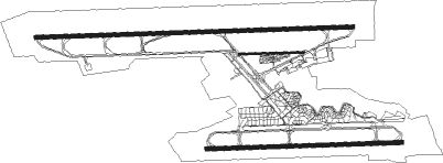
Runway info
Runway 09R / 27L  | ||
| length | 2334m (7657ft) | |
| bearing | 92° / 272° | |
| width | 45m (148ft) | |
| surface | concrete | |
| Runway 09C / 27C | ||
| length | 777m (2549ft) | |
| bearing | 92° / 272° | |
| width | 23m (75ft) | |
| surface | asphalt | |
| displ threshold | 58m (190ft) / 171m (561ft) | |
| Runway 09L / 27R | ||
| length | 3791m (12438ft) | |
| bearing | 92° / 272° | |
| width | 47m (154ft) | |
| surface | concrete | |
| displ threshold | 300m (984ft) / 300m (984ft) | |
Nearby beacons
| code | identifier | dist | bearing | frequency |
|---|---|---|---|---|
| HAD | DME | 0.3 | 38° | 113.95 |
| HBD | DME | 1.2 | 256° | 116.90 |
| HA | HANNOVER NDB | 4.1 | 90° | 320 |
| HW | HANNOVER NDB | 5.3 | 272° | 358 |
| WUN | WUNSTORF TACAN | 9.6 | 268° | 114.85 |
| CEL | CELLE NDB | 14.4 | 70° | 311 |
| DLE | LEINE VOR/DME | 14.6 | 138° | 115.20 |
| SAS | SARSTEDT VOR/DME | 14.6 | 138° | 114.45 |
| NIE | NIENBURG VOR | 15.2 | 297° | 116.50 |
| BYC | BUECKEBURG NDB | 24.3 | 254° | 368 |
| FSB | FASSBERG NDB | 32.6 | 48° | 284 |
| BRU | BRAUNSCHWEIG-WOLFSBURG NDB | 34.5 | 99° | 427 |
| HIG | BREMEN NDB | 45.2 | 307° | 318 |
| BND | DME | 48 | 303° | 113.65 |
| BMN | BREMEN VOR/DME | 48.6 | 302° | 117.45 |
| WSN | WESER NDB | 60.7 | 317° | 378 |
| WRB | WARBURG VOR/DME | 61.3 | 211° | 113.70 |
Departure and arrival routes
| Transition altitude | 5000ft |
| SID end points | distance | outbound heading | |
|---|---|---|---|
| RW09L | |||
| CEL6Y | 14mi | 70° | |
| MULD5Y | 31mi | 93° | |
| POVE2Y | 46mi | 106° | |
| WERA3Y | 60mi | 178° | |
| WRB3Y | 61mi | 211° | |
| VAXE1Y | 22mi | 264° | |
| NIE1Y | 15mi | 297° | |
| RW09R | |||
| CEL9G | 14mi | 70° | |
| MULD6G | 31mi | 93° | |
| POVE2H | 46mi | 106° | |
| WERA3G | 60mi | 178° | |
| WRB1G | 61mi | 211° | |
| VAXE1G | 22mi | 264° | |
| NIE7G | 15mi | 297° | |
| RW27L | |||
| CEL8F | 14mi | 70° | |
| MULD8F | 31mi | 93° | |
| POVE3F | 46mi | 106° | |
| WERA3F | 60mi | 178° | |
| WRB8F | 61mi | 211° | |
| VAXE1F | 22mi | 264° | |
| NIE7F | 15mi | 297° | |
| RW27R | |||
| CEL6S | 14mi | 70° | |
| MULD6S | 31mi | 93° | |
| POVE3S | 46mi | 106° | |
| WERA3S | 60mi | 178° | |
| WRB3S | 61mi | 211° | |
| VAXE1S | 22mi | 264° | |
| NIE9S | 15mi | 297° | |
| STAR starting points | distance | inbound heading | |
|---|---|---|---|
| RW09 (ALL) | |||
| ELNA2R | 75.6 | 0° | |
| WRB5R | 61.3 | 31° | |
| HLZ6R | 40.8 | 275° | |
| GITE4R | 41.3 | 299° | |
| WERA2R | 59.6 | 358° | |
| RW09L | |||
| TOLT3A | 47.0 | 13° | |
| WRB3A | 61.3 | 31° | |
| ROBE09 | 25.6 | 84° | |
| KUGA3A | 39.7 | 88° | |
| NIE09, CEL09 | 25.6 | 98° | |
| ESTA3A | 63.9 | 173° | |
| OBAT3A | 30.1 | 252° | |
| HLZ1A | 40.8 | 275° | |
| RW09R | |||
| TOLT3E | 47.0 | 13° | |
| WRB3E | 61.3 | 31° | |
| ROBE09 | 25.6 | 84° | |
| KUGA3E | 39.7 | 88° | |
| CEL09, NIE09 | 25.6 | 98° | |
| ESTA3E | 63.9 | 173° | |
| OBAT3E | 30.1 | 252° | |
| HLZ1E | 40.8 | 275° | |
| RW27 (ALL) | |||
| ELNA5P | 75.6 | 0° | |
| WRB8P | 61.3 | 31° | |
| HLZ6P | 40.8 | 275° | |
| GITE5P | 41.3 | 299° | |
| WERA2P | 59.6 | 358° | |
| RW27L | |||
| VISK3D | 32.9 | 96° | |
| OBAT3D | 30.1 | 252° | |
| CEL27, NIE27 | 25.7 | 265° | |
| HLZ3D | 40.8 | 275° | |
| DLE27 | 25.8 | 279° | |
| UPDA3D | 37.5 | 315° | |
| RW27R | |||
| VISK3L | 32.9 | 96° | |
| OBAT3L | 30.1 | 252° | |
| NIE27, CEL27 | 25.7 | 265° | |
| HLZ3L | 40.8 | 275° | |
| DLE27 | 25.8 | 279° | |
| UPDA3L | 37.5 | 315° | |
Instrument approach procedures
| runway | airway (heading) | route (dist, bearing) |
|---|---|---|
| RW09L | CEL (250°) | CEL NIE (24mi, 273°) 4000ft DV630 (5mi, 217°) 3000ft DV632 (4mi, 184°) DESIM (4mi, 91°) 3000ft |
| RW09L | NIE (117°) | NIE DV630 (5mi, 217°) 3000ft DV632 (4mi, 184°) DESIM (4mi, 91°) 3000ft |
| RW09L | ROBEG (61°) | ROBEG DV631 (6mi, 15°) 4000ft DV632 (8mi, 4°) DESIM (4mi, 91°) 3000ft |
| RNAV | DESIM 3000ft EDDV (10mi, 92°) 217ft DV635 (2mi, 87°) NIE (16mi, 294°) 4000ft | |
| RW09R | CEL (250°) | CEL NIE (24mi, 273°) 4000ft DV640 (5mi, 204°) 3000ft DV642 (5mi, 184°) PIXEL (4mi, 91°) 3000ft |
| RW09R | NIE (117°) | NIE DV640 (5mi, 204°) 3000ft DV642 (5mi, 184°) PIXEL (4mi, 91°) 3000ft |
| RW09R | ROBEG (61°) | ROBEG DV641 (6mi, 27°) 4000ft DV642 (8mi, 4°) PIXEL (4mi, 91°) 3000ft |
| RNAV | PIXEL 3000ft EDDV (9mi, 90°) 222ft DV153 (7mi, 94°) SAS (12mi, 176°) ROBEG (23mi, 268°) 4000ft | |
| RW27L | CEL (250°) | CEL DV600 (5mi, 157°) 4000ft DV602 (4mi, 185°) 3000ft ODINI (4mi, 272°) 3000ft |
| RW27L | NIE (117°) | NIE CEL (24mi, 93°) 4000ft DV600 (5mi, 157°) 4000ft DV602 (4mi, 185°) ODINI (4mi, 272°) 3000ft |
| RW27L | SAS (318°) | SAS DV601 (9mi, 55°) 3000ft DV602 (5mi, 5°) ODINI (4mi, 272°) 3000ft |
| RNAV | ODINI 3000ft EDDV (9mi, 274°) 229ft DV607 (2mi, 263°) DV608 (5mi, 220°) SAS (14mi, 113°) 4000ft | |
| RW27R | CEL (250°) | CEL DV610 (4mi, 161°) 4000ft DV612 (4mi, 185°) 3000ft XAVER (4mi, 272°) 3000ft |
| RW27R | NIE (117°) | NIE CEL (24mi, 93°) 4000ft DV610 (4mi, 161°) 4000ft DV612 (4mi, 185°) 3000ft XAVER (4mi, 272°) 3000ft |
| RW27R | SAS (318°) | SAS DV611 (10mi, 48°) 3000ft DV612 (4mi, 5°) XAVER (4mi, 272°) 3000ft |
| RNAV | XAVER 3000ft DV614 (8mi, 272°) 420ft EDDV (turn) (3188mi, 190°) 600ft DV617 (3197mi, 10°) 3000ft CEL (15mi, 93°) 4000ft |
Holding patterns
| STAR name | hold at | type | turn | heading* | altitude | leg | speed limit |
|---|---|---|---|---|---|---|---|
| CEL09 | CEL | FIX | right | 77 (257)° | > 4000ft | 1.0min timed | ICAO rules |
| CEL27 | CEL | FIX | right | 77 (257)° | > 4000ft | 1.0min timed | ICAO rules |
| DLE27 | DLE | NDB | left | 268 (88)° | > 4000ft | 1.0min timed | ICAO rules |
| ELNA2R | ROBEG | VHF | right | 187 (7)° | > 4000ft | 1.0min timed | ICAO rules |
| ELNA5P | SAS | NDB | left | 268 (88)° | > 4000ft | 1.0min timed | ICAO rules |
| GITE4R | ROBEG | VHF | right | 187 (7)° | > 4000ft | 1.0min timed | ICAO rules |
| GITE5P | SAS | NDB | left | 268 (88)° | > 4000ft | 1.0min timed | ICAO rules |
| HLZ6P | CEL | FIX | right | 77 (257)° | > 4000ft | 1.0min timed | ICAO rules |
| HLZ6R | CEL | FIX | right | 77 (257)° | > 4000ft | 1.0min timed | ICAO rules |
| HLZ6R | NIE | NDB | right | 1 (181)° | > 4000ft | 1.0min timed | ICAO rules |
| NIE09 | NIE | NDB | right | 1 (181)° | > 4000ft | 1.0min timed | ICAO rules |
| NIE27 | NIE | NDB | right | 1 (181)° | > 4000ft | 1.0min timed | ICAO rules |
| ROBE09 | ROBEG | VHF | right | 187 (7)° | > 4000ft | 1.0min timed | ICAO rules |
| WERA2P | SAS | NDB | left | 268 (88)° | > 4000ft | 1.0min timed | ICAO rules |
| WERA2R | ROBEG | VHF | right | 187 (7)° | > 4000ft | 1.0min timed | ICAO rules |
| WRB5R | ROBEG | VHF | right | 187 (7)° | > 4000ft | 1.0min timed | ICAO rules |
| WRB8P | SAS | NDB | left | 268 (88)° | > 4000ft | 1.0min timed | ICAO rules |
| *) magnetic outbound (inbound) holding course | |||||||
Disclaimer
The information on this website is not for real aviation. Use this data with the X-Plane flight simulator only! Data taken with kind consent from X-Plane 12 source code and data files. Content is subject to change without notice.