Marl - Marl- Loemuehle
Airport details
| Country | Germany |
| State | North Rhine-Westphalia |
| Region | ED |
| Airspace | Langen Ctr |
| Municipality | Recklinghausen |
| Elevation | 238ft (73m) |
| Timezone | GMT +1 |
| Coordinates | 51.64700, 7.16367 |
| Magnetic var | |
| Type | land |
| Available since | X-Plane v10.40 |
| ICAO code | EDLM |
| IATA code | n/a |
| FAA code | n/a |
Communication
| Marl- Loemuehle Marl Info | 122.000 |
Nearby Points of Interest:
Amtsgericht Recklinghausen
-Rathaus Marl
-Zeche Auguste Victoria
-Schlosskapelle Herten
-St. Johannes
-Lippramsdorf railway station
-Pilgrimage area of Annaberg (Haltern am See)
-Haus Lüttinghof
-Gelsenkirchen-Siedlung Spinnstuhl
-Haus Leythe
-Bergmannsglück mine
-Haltern
-Propsteikirche St. Urbanus
-Crooked dog
-Luisenstraße 28
-St. Mariä Heimsuchung
-Viktor-Reuter-Straße 18
-Siedlung Fürst Leopold
-Bebelstraße 12-16, Neustraße 19-21
-Kaiserbrunnen
-Dorstener Straße 279
-Rathaus
-Rathaus Herne
-Amtsgericht Herne
-Postamt (Wanne)
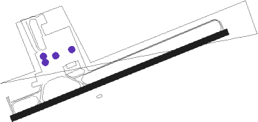
Runway info
| Runway 07 / 25 | ||
| length | 829m (2720ft) | |
| bearing | 79° / 259° | |
| width | 20m (66ft) | |
| surface | asphalt | |
| displ threshold | 128m (420ft) / 20m (66ft) | |
Nearby beacons
| code | identifier | dist | bearing | frequency |
|---|---|---|---|---|
| BOT | BOTTROP NDB | 6.4 | 246° | 406 |
| DOR | WICKEDE (DORTMUND) VOR/DME | 18.9 | 105° | 108.65 |
| DWI | DORTMUND-WICKEDE NDB | 19 | 104° | 357 |
| BAM | BARMEN VOR/DME | 19.1 | 178° | 114 |
| LI | DUESSELDORF NDB | 20.6 | 222° | 417 |
| HMM | HAMM VOR/DME | 23.8 | 69° | 115.65 |
| DUS | DUESSELDORF VOR/DME | 26.6 | 228° | 115.15 |
| DY | DUESSELDORF NDB | 31.2 | 231° | 284 |
| RKN | DME | 32.7 | 321° | 116.80 |
| LMA | LIMA NDB | 33.1 | 250° | 311 |
| MHD | DME | 35.2 | 238° | 112.50 |
| MHV | MOENCHENGLADBACH VOR | 35.2 | 239° | 109.80 |
| MOD | DME | 35.2 | 47° | 114.05 |
| WYP | WIPPER VOR | 36.2 | 169° | 109.60 |
| LAA | NIEDERRHEIN NDB | 37 | 267° | 352 |
| MYN | MUENSTER/OSNABRUECK NDB | 38.7 | 51° | 371 |
| GMH | GERMINGHAUSEN VOR/DME | 39.5 | 123° | 115.40 |
| LJ | COLOGNE-BONN NDB | 43.4 | 188° | 365 |
| LW | COLOGNE-BONN NDB | 45 | 173° | 300 |
| KBO | COLOGNE-BONN VOR/DME | 47.1 | 181° | 112.15 |
| LV | COLOGNE-BONN NDB | 50.6 | 175° | 327 |
| WNN | DME | 52.1 | 211° | 109.85 |
| NVO | NOERVENICH VORTAC | 53.3 | 213° | 116.20 |
| COL | COLA VOR/DME | 54.3 | 154° | 108.80 |
| SLD | DME | 66.1 | 136° | 108.05 |
| SIL | SIEGERLAND NDB | 68.7 | 135° | 489 |
Disclaimer
The information on this website is not for real aviation. Use this data with the X-Plane flight simulator only! Data taken with kind consent from X-Plane 12 source code and data files. Content is subject to change without notice.