Airports for X-Plane offers a convenient way to explore airports and their related communication information for the X-Plane flight simulator. It only uses data from the X-Plane flight simulator itself, and is therefore more reliable than the data that comes from real aviation websites. You can search for airports by using the ICAO code, or browse for airports per country and state. The information displayed is categorized by airport details, runway information, airport communication, approach frequencies (ILS and Glidepath details), details of nearby beacons, SIDs, STARs and approach procedures.

airfield luggage non-towered airport military station port public transport taxi passengers stopover airline flight rail nearby metro buildings control tower downtown air safety runway

Vilshofen

Airport details

CountryGermany
StateBavaria
RegionED
AirspaceMunich Ctr
MunicipalityVilshofen an der Donau
Elevation990ft (302m)
TimezoneGMT +1
Coordinates48.63708, 13.19150
Magnetic var
Typeland
Available sinceX-Plane v10.40
ICAO codeEDMV
IATA coden/a
FAA coden/a

Communication

Vilshofen Vilshofen Info119.175
Nearby Points of Interest:
St. Petrus und Paulus (Aicha vorm Wald)
-
Schloss Walchsing
-
Wallfahrtskirche Handlab
-
Aldersbach Abbey
-
Cultural heritage D-2-7344-0198 in Osterhofen
-
Osterhofen Abbey
-
Saint Martin's church
-
Kloster Fürstenzell
-
Wallfahrtskirche zum Kreuzberg
-
St. Valentin (Reutern, Bad Griesbach im Rottal)
-
Wallfahrtskirche Maria Schutz Kronberg
-
Schloss Ottmaring
-
Saint John the Baptist Church
-
Schloss Eggendobl
-
Stadtpfarrkirche Heilige Familie in Bad Griesbach (Rottal)
-
Schloss Griesbach
-
Katholische Pfarrkirche Sankt Laurentius
-
St. Johannes d.T. (Weng, Bad Griesbach im Rottal)
-
Franziskanerkloster Passau
-
Sankt Johann Baptist
-
Friedhof
-
Alt-Daun-Hof
-
Lamberg-Kapelle
-
Trennbach Chapel
-
Sixtuskapelle

Runway info

Runway 12 / 30
 length1255m (4117ft)
 bearing112° / 292°
 width20m (66ft)
 surfaceasphalt
 displ threshold260m (853ft) / 122m (400ft)

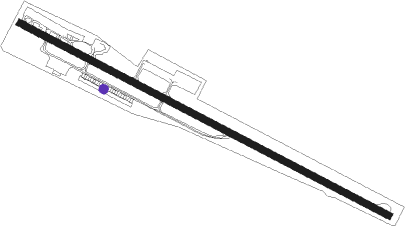
Airport layout - parking location Southeast


Parking locations

Nearby beacons

codeidentifierdistbearingfrequency
RDGRODING VOR/DME35.7301°114.70
FREDME39.2102°113.50
SBGSALZBURG VOR/DME39.9205°113.80
SBGSALZBURG NDB41.9204°382
LNZLINZ VOR/DME43.7114°116.60
SISALZBURG NDB49.8194°410
GSBDME50185°109.45

Disclaimer

The information on this website is not for real aviation. Use this data with the X-Plane flight simulator only! Data taken with kind consent from X-Plane 12 source code and data files. Content is subject to change without notice.