Bruck In Der Oberpfalz - Nittenau - Bruck
Airport details
| Country | Germany |
| State | Bavaria |
| Region | ED |
| Airspace | Munich Ctr |
| Municipality | Nittenau |
| Elevation | 1161ft (354m) |
| Timezone | GMT +1 |
| Coordinates | 49.22211, 12.29679 |
| Magnetic var | |
| Type | land |
| Available since | X-Plane v10.40 |
| ICAO code | EDNM |
| IATA code | n/a |
| FAA code | n/a |
Communication
| Nittenau - Bruck Bruck Info | 128.750 |
Nearby Points of Interest:
Burggut Nittenau
-Burgstall Bodenwöhr
-Burg Altenschwand
-Schloss Hirschling
-Burgruine Ramspau
-Burg Adlmannstein
-Ehemaliger Pfarrhof
-Mater Dolorosa
-Maxhütte
-Burg Regenpeilstein
-Unteres Schloss
-Schloss Schönberg (Wenzenbach)
-Burgruine Wetterfeld
-Felsenkeller in Schwandorf
-Burg Schwandorf
-Burgstall Oberlichtenwald
-Burgruine Kürnberg
-Rathaus, ehemaliges Pflegamt
-Altes Schloss Ettmannsdorf
-St. Bartholomäus (Altfalter)
-Burgstall Altenthannstein
-Schloss Thanstein
-St. Dionysius und Ägidius
-Ehemaliges Rathaus
-Burgstall Auburg
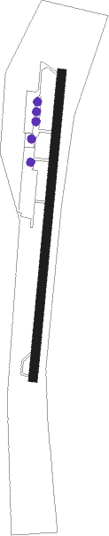
Runway info
| Runway 01 / 19 | ||
| length | 550m (1804ft) | |
| bearing | 15° / 195° | |
| width | 15m (49ft) | |
| surface | asphalt | |
| displ threshold | 100m (328ft) / 70m (230ft) | |
Nearby beacons
| code | identifier | dist | bearing | frequency |
|---|---|---|---|---|
| RDG | RODING VOR/DME | 14.1 | 128° | 114.70 |
| HFX | HOHENFELS NDB | 17.1 | 270° | 286 |
| GRF | GRAFENWOHR TACAN | 31.4 | 323° | 111.80 |
| GRW | GRAFENWOHR NDB | 31.5 | 323° | 405 |
| IGL | INGOLSTADT NDB | 38.8 | 233° | 345 |
| IGL | INGOLSTADT TACAN | 41.6 | 235° | 111.40 |
| MIQ | MIKE NDB | 47.9 | 227° | 426 |
| OKG | CHEB VOR/DME | 50.8 | 7° | 115.70 |
| BAY | BAYREUTH VOR | 52.5 | 319° | 110.60 |
| MNW | MUNICH NDB | 53.1 | 204° | 338 |
| MSW | MUNICH NDB | 54.4 | 204° | 400 |
| DMN | DME | 55 | 210° | 116 |
| DMS | DME | 56.7 | 210° | 115 |
| MNE | MUNICH NDB | 57.5 | 216° | 369 |
| MSE | MUNICH NDB | 59.1 | 216° | 358 |
| L | VRATA (KARLOVY VARY) NDB | 63.6 | 34° | 365 |
| MAH | MAISACH VOR/DME | 69.5 | 226° | 115.20 |
Disclaimer
The information on this website is not for real aviation. Use this data with the X-Plane flight simulator only! Data taken with kind consent from X-Plane 12 source code and data files. Content is subject to change without notice.