Bayreuth
Airport details
| Country | Germany |
| State | Bavaria |
| Region | ED |
| Airspace | Munich Ctr |
| Municipality | Bindlach |
| Elevation | 1601ft (488m) |
| Timezone | GMT +1 |
| Coordinates | 49.98443, 11.63857 |
| Magnetic var | |
| Type | land |
| Available since | X-Plane v10.40 |
| ICAO code | EDQD |
| IATA code | BYU |
| FAA code | n/a |
Communication
| Bayreuth Bayreuth Info | 127.525 |
Nearby Points of Interest:
St. Walburga
-Schloss Nemmersdorf
-Justizvollzugsanstalt St. Georgen-Bayreuth
-Friedhof St. Georgen
-Besucherbergwerke Goldkronach
-Burgstall Lichteburg
-Regierung von Oberfranken
-Cultural heritage D-4-62-000-142 in Bayreuth
-Ellrodtscher Gartenportikus
-Baudenkmal
-Gericht
-Justizpalast Bayreuth
-Befestigung auf der Zottaschen
-Marienkirche (Himmelkron)
-Burgruine Wurzstein
-Town Hall Eckersdorf
-Rathaus
-Motte Gefrees-Bühl
-Pfarrkirche
-Pfarrhaus
-Motte Haidenschloss
-Motte Witzleshofen
-Mariensäule
-Cultural heritage D-4-77-163-30 in Wirsberg
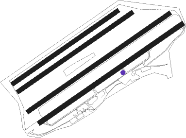
Runway info
Runway 06 / 24  | ||
| length | 1092m (3583ft) | |
| bearing | 69° / 249° | |
| width | 30m (98ft) | |
| surface | asphalt | |
| displ threshold | 0m (0ft) / 60m (197ft) | |
| blast zone | 108m (354ft) / 0m (0ft) | |
| Runway 05R / 23L | ||
| length | 1082m (3550ft) | |
| bearing | 69° / 249° | |
| width | 28m (92ft) | |
| surface | grass | |
| Runway 05C / 23C | ||
| length | 868m (2848ft) | |
| bearing | 69° / 249° | |
| width | 28m (92ft) | |
| surface | grass | |
| Runway 05L / 23R | ||
| length | 799m (2621ft) | |
| bearing | 69° / 249° | |
| width | 28m (92ft) | |
| surface | grass | |
Nearby beacons
| code | identifier | dist | bearing | frequency |
|---|---|---|---|---|
| BAY | BAYREUTH VOR | 0 | 291° | 110.60 |
| GRW | GRAFENWOHR NDB | 20.9 | 134° | 405 |
| GRF | GRAFENWOHR TACAN | 21 | 134° | 111.80 |
| ERL | ERLANGEN VOR/DME | 27.3 | 236° | 114.90 |
| OKG | CHEB VOR/DME | 29.9 | 84° | 115.70 |
| RTB | ROETHENBACH NDB | 33.6 | 218° | 415 |
| NGD | DME | 36.2 | 229° | 113.10 |
| NUB | NUERNBERG VOR/DME | 37.2 | 231° | 115.75 |
| HFX | HOHENFELS NDB | 46.8 | 164° | 286 |
| ERF | ERFURT VOR/DME | 60 | 337° | 113.85 |
| EFD | DME | 65.3 | 326° | 112.05 |
| RDG | RODING VOR/DME | 66.4 | 137° | 114.70 |
| AGD | DME | 68.6 | 41° | 115.30 |
Departure and arrival routes
| Transition altitude | 5000ft |
| SID end points | distance | outbound heading | |
|---|---|---|---|
| RW06 | |||
| ABER3R | 18mi | 79° | |
| PIVI2R | 21mi | 215° | |
| ANEL3R | 21mi | 242° | |
| LONL3R | 17mi | 282° | |
| RW24 | |||
| ABER2G | 18mi | 79° | |
| PIVI1G | 21mi | 215° | |
| ANEL2G | 21mi | 242° | |
| LONL2G | 17mi | 282° | |
| STAR starting points | distance | inbound heading | |
|---|---|---|---|
| ALL | |||
| ANEL5Z | 20.6 | 62° | |
| LONL5Z | 16.8 | 102° | |
Instrument approach procedures
| runway | airway (heading) | route (dist, bearing) |
|---|---|---|
| RW06 | ANELA (62°) | ANELA D040H (8mi, 55°) 4800ft VADKO (2mi, 55°) 3600ft |
| RW06 | KULOK (175°) | KULOK QD001 (4mi, 239°) 5000ft QD002 (9mi, 249°) 5000ft VADKO (4mi, 138°) 3600ft |
| RNAV | VADKO 3600ft BETUT (4mi, 69°) 3600ft EDQD (6mi, 69°) 1637ft QD003 (turn) QD004 (3mi, 310°) VADKO (11mi, 238°) 5000ft |
Holding patterns
| STAR name | hold at | type | turn | heading* | altitude | leg | speed limit |
|---|---|---|---|---|---|---|---|
| ANEL5Z | VADKO | VHF | left | 237 (57)° | > 5000ft | 1.0min timed | 170 |
| KULO5Z | VADKO | VHF | left | 237 (57)° | > 5000ft | 1.0min timed | 170 |
| LONL5Z | VADKO | VHF | left | 237 (57)° | > 5000ft | 1.0min timed | 170 |
| *) magnetic outbound (inbound) holding course | |||||||
Disclaimer
The information on this website is not for real aviation. Use this data with the X-Plane flight simulator only! Data taken with kind consent from X-Plane 12 source code and data files. Content is subject to change without notice.