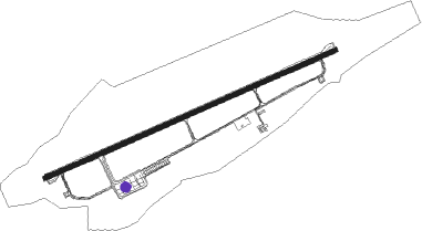
Keila - Ämari Military Aerodrome
Airport details
| Country | Estonia |
| State | Harju County |
| Region | EE |
| Airspace | Tallinn Ctr |
| Municipality | Lääne-Harju vald |
| Elevation | 65ft (20m) |
| Timezone | GMT +2 |
| Coordinates | 59.26222, 24.21861 |
| Magnetic var | |
| Type | land |
| Available since | X-Plane v10.32 |
| ICAO code | EEEI |
| IATA code | n/a |
| FAA code | n/a |
Communication
| Ämari Military Aerodrome ATIS | 123.875 |
| Ämari Military Aerodrome Ämari Tower EMERGENCY | 121.500 |
| Ämari Military Aerodrome Ämari Tower EMERGENCY | 243.000 |
| Ämari Military Aerodrome Ämari Tower | 120.900 |
| Ämari Military Aerodrome Ämari Tower | 257.800 |
Approach frequencies
| ILS-cat-I | RW06 | 108.7 | 18.00mi |
| ILS-cat-I | RW24 | 108.7 | 18.00mi |
| 3° GS | RW06 | 108.7 | 18.00mi |
| 3° GS | RW24 | 108.7 | 18.00mi |
Nearby beacons
| code | identifier | dist | bearing | frequency |
|---|---|---|---|---|
| G | AMARI NDB | 0.8 | 80° | 432 |
| AMI | AMARI VORTAC | 0.9 | 80° | 115.30 |
| GO | AMARI NDB | 5.4 | 80° | 514 |
| TLL | TALLINN VOR/DME | 20.9 | 76° | 112.20 |
| KAD | (HELSINKI) DME | 59.2 | 44° | 117.50 |
Disclaimer
The information on this website is not for real aviation. Use this data with the X-Plane flight simulator only! Data taken with kind consent from X-Plane 12 source code and data files. Content is subject to change without notice.
