Tallinn - Lennart Meri Tallinn
Airport details
| Country | Estonia |
| State | Harju County |
| Region | EE |
| Airspace | Tallinn Ctr |
| Municipality | Tallinn |
| Elevation | 136ft (41m) |
| Timezone | GMT +2 |
| Coordinates | 59.41333, 24.83250 |
| Magnetic var | |
| Type | land |
| Available since | X-Plane v10.40 |
| ICAO code | EETN |
| IATA code | TLL |
| FAA code | n/a |
Communication
| Lennart Meri Tallinn Tallinn Info | 124.880 |
| Lennart Meri Tallinn De-Icing | 121.780 |
| Lennart Meri Tallinn Tallinn Handling | 131.905 |
| Lennart Meri Tallinn Tallinn Tower | 135.905 |
| Lennart Meri Tallinn Tallinn Radar | 125.405 |
| Lennart Meri Tallinn Tallinn Radar | 127.905 |
Approach frequencies
| ILS-cat-I | RW08 | 108.3 | 18.00mi |
| ILS-cat-I | RW26 | 109.3 | 18.00mi |
| 3° GS | RW08 | 108.3 | 18.00mi |
| 3° GS | RW26 | 109.3 | 18.00mi |
Nearby Points of Interest:
Mõigu cemetery
-Linda kivi
-The Danse Macabre
-Belvedere Apollo
-Presidential Palace
-Oru rändrahn
-Noortepargi kivi
-Tallinn Song Festival stage
-Kadriorg Park
-Monument to the leaders of the War of Independence
-Vana-Kaarli kalmistu kabel
-Maarjamäe Palace
-A.M. Luther Community House
-Lutheri villa
-Boys with a Fish
-Tallinn Volontary Fire Brigade Station
-Rotermann Salt Storage
-Gingko tree at Süda street
-Vene seltskondliku kogu hoone
-Tallinna Piiritusevabriku administratiivhoone
-Saarinen House
-Gloria Palace
-Pirita Cemetery
-Elamu Raekoja plats 17
-Raekoja plats 16
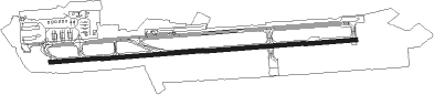
Runway info
| Runway 08 / 26 | ||
| length | 3483m (11427ft) | |
| bearing | 90° / 270° | |
| width | 45m (148ft) | |
| surface | asphalt | |
| displ threshold | 240m (787ft) / 0m (0ft) | |
Nearby beacons
| code | identifier | dist | bearing | frequency |
|---|---|---|---|---|
| TLL | TALLINN VOR/DME | 0.2 | 109° | 112.20 |
| GO | AMARI NDB | 15.4 | 255° | 514 |
| AMI | AMARI VORTAC | 19.9 | 256° | 115.30 |
| G | AMARI NDB | 20 | 256° | 432 |
| KAD | (HELSINKI) DME | 44.6 | 19° | 117.50 |
| VI | DME | 50.9 | 136° | 114.90 |
| HEL | HELSINKI VOR/DME | 55.6 | 7° | 114.20 |
| PVO | DME | 57.6 | 41° | 112.80 |
Departure and arrival routes
| Transition altitude | 5000ft |
| SID end points | distance | outbound heading | |
|---|---|---|---|
| RW08 | |||
| INTO1S | 27mi | 41° | |
| MOHN1S | 37mi | 57° | |
| BIRS1S | 41mi | 104° | |
| GONO1S | 36mi | 122° | |
| NITS1S | 37mi | 167° | |
| ORTA1S | 37mi | 222° | |
| LONS1S | 37mi | 252° | |
| OSMU1S | 43mi | 263° | |
| PETO1S | 52mi | 273° | |
| RW26 | |||
| INTO1T | 27mi | 41° | |
| MOHN1T | 37mi | 57° | |
| BIRS1T | 41mi | 104° | |
| GONO1T | 36mi | 122° | |
| NITS1T | 37mi | 167° | |
| ORTA1T | 37mi | 222° | |
| LONS1T | 37mi | 252° | |
| OSMU1T | 43mi | 263° | |
| PETO1T | 52mi | 273° | |
| STAR starting points | distance | inbound heading | |
|---|---|---|---|
| RW08 | |||
| KEME1K | 42.1 | 20° | |
| SULU1K | 35.4 | 60° | |
| OSMU1K | 42.7 | 83° | |
| DOBA1K | 25.9 | 135° | |
| RENK1K | 28.4 | 188° | |
| DOPI1K | 37.1 | 269° | |
| GONO1K | 36.3 | 302° | |
| RW26 | |||
| KEME1L | 42.1 | 20° | |
| SULU1L | 35.4 | 60° | |
| OSMU1L | 42.7 | 83° | |
| DOBA1L | 25.9 | 135° | |
| RENK1L | 28.4 | 188° | |
| DOPI1L | 37.1 | 269° | |
| GONO1L | 36.3 | 302° | |
Instrument approach procedures
| runway | airway (heading) | route (dist, bearing) |
|---|---|---|
| RW08-Z | VEMOX (90°) | VEMOX 2200ft |
| RNAV | VEMOX 2200ft TN978 (3mi, 90°) 2200ft EETN (7mi, 90°) 184ft TN551 (12mi, 90°) 2200ft | |
| RW26-Z | MOKEX (270°) | MOKEX 2200ft |
| RNAV | MOKEX 2200ft TN627 (3mi, 270°) 2200ft EETN (7mi, 270°) 189ft TN901 (12mi, 270°) 2200ft |
Holding patterns
| STAR name | hold at | type | turn | heading* | altitude | leg | speed limit |
|---|---|---|---|---|---|---|---|
| DOPI1K | DOPIK | VHF | left | 78 (258)° | 10000ft - 14000ft | 1.0min timed | 280 |
| DOPI1L | DOPIK | VHF | left | 78 (258)° | 10000ft - 14000ft | 1.0min timed | 280 |
| GONO1K | GONOS | VHF | right | 132 (312)° | 10000ft - 14000ft | 1.0min timed | 280 |
| GONO1L | GONOS | VHF | right | 132 (312)° | 10000ft - 14000ft | 1.0min timed | 280 |
| KEME1K | KEMET | VHF | right | 182 (2)° | 10000ft - 14000ft | 1.0min timed | 280 |
| KEME1L | KEMET | VHF | right | 182 (2)° | 10000ft - 14000ft | 1.0min timed | 280 |
| OSMU1K | OSMUR | VHF | left | 249 (69)° | 10000ft - 14000ft | 1.0min timed | 280 |
| OSMU1L | OSMUR | VHF | left | 249 (69)° | 10000ft - 14000ft | 1.0min timed | 280 |
| SULU1K | SULUN | VHF | right | 213 (33)° | 10000ft - 14000ft | 1.0min timed | 280 |
| SULU1L | SULUN | VHF | right | 213 (33)° | 10000ft - 14000ft | 1.0min timed | 280 |
| *) magnetic outbound (inbound) holding course | |||||||
Disclaimer
The information on this website is not for real aviation. Use this data with the X-Plane flight simulator only! Data taken with kind consent from X-Plane 12 source code and data files. Content is subject to change without notice.