Hyvinkää - Hyvinkaa
Airport details
| Country | Finland |
| State | Southern Finland |
| Region | EF |
| Airspace | Helsinki Ctr |
| Municipality | Hyvinkää |
| Elevation | 430ft (131m) |
| Timezone | GMT +2 |
| Coordinates | 60.65308, 24.88193 |
| Magnetic var | |
| Type | land |
| Available since | X-Plane v10.40 |
| ICAO code | EFHV |
| IATA code | HYV |
| FAA code | n/a |
Communication
| Hyvinkaa TRAFFIC | 122.500 |
Nearby Points of Interest:
Wanha villatehdas
-Erkylä Manor
-Kytäjä church
-Riihimäki Prison
-Rajamäki railway station
-Mommila Manor
-Unikonlinna
-Laurinlähde
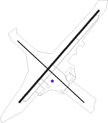
Runway info
Runway 04 / 22  | ||
| length | 1261m (4137ft) | |
| bearing | 64° / 244° | |
| width | 18m (59ft) | |
| surface | asphalt | |
| Runway 12 / 30 | ||
| length | 944m (3097ft) | |
| bearing | 118° / 298° | |
| width | 8m (26ft) | |
| surface | asphalt | |
| displ threshold | 0m (0ft) / 155m (509ft) | |
Nearby beacons
| code | identifier | dist | bearing | frequency |
|---|---|---|---|---|
| ANT | DME | 14.5 | 49° | 113.70 |
| HEL | HELSINKI VOR/DME | 19 | 167° | 114.20 |
| VTI | DME | 22.1 | 253° | 117 |
| ORM | (HELSINKI) DME | 28 | 78° | 117.30 |
| PVO | DME | 30 | 117° | 112.80 |
| KAD | (HELSINKI) DME | 30.9 | 159° | 117.50 |
Disclaimer
The information on this website is not for real aviation. Use this data with the X-Plane flight simulator only! Data taken with kind consent from X-Plane 12 source code and data files. Content is subject to change without notice.