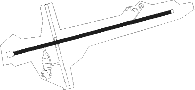
Kajaani
Airport details
| Country | Finland |
| State | Oulu |
| Region | EF |
| Airspace | Helsinki Ctr |
| Municipality | Kajaani |
| Elevation | 479ft (146m) |
| Timezone | GMT +2 |
| Coordinates | 64.28416, 27.68750 |
| Magnetic var | |
| Type | land |
| Available since | X-Plane v10.40 |
| ICAO code | EFKI |
| IATA code | KAJ |
| FAA code | n/a |
Communication
| Kajaani AFIS | 119.700 |
| Kajaani AFIS | 118.100 |
Approach frequencies
| ILS-cat-I | RW07 | 109.9 | 18.00mi |
| 3° GS | RW07 | 109.9 | 18.00mi |
Nearby Points of Interest:
Paltaniemi Church
-Kivesjärvi railway station
Nearby beacons
| code | identifier | dist | bearing | frequency |
|---|---|---|---|---|
| KNI | DME | 0.8 | 267° | 114.90 |
Departure and arrival routes
| Transition altitude | 5000ft |
| SID end points | distance | outbound heading | |
|---|---|---|---|
| RW07 | |||
| EVRI2C | 21mi | 61° | |
| ETRO2C | 20mi | 161° | |
| ODRU1C | 24mi | 255° | |
| UBIG2C | 24mi | 277° | |
| RW25 | |||
| EVRI3D | 21mi | 61° | |
| ETRO2D | 20mi | 161° | |
| ODRU1D | 24mi | 255° | |
| UBIG2D | 24mi | 277° | |
| STAR starting points | distance | inbound heading | |
|---|---|---|---|
| RW07 | |||
| ODRU1A | 24.1 | 75° | |
| UBIG2A | 23.7 | 97° | |
| EVRI2A | 21.1 | 241° | |
| ETRO3A | 20.2 | 341° | |
| RW25 | |||
| ODRU1B | 24.1 | 75° | |
| UBIG2B | 23.7 | 97° | |
| EVRI2B | 21.1 | 241° | |
| ETRO3B | 20.2 | 341° | |
Instrument approach procedures
| runway | airway (heading) | route (dist, bearing) |
|---|---|---|
| RW07 | ETEVI (73°) | ETEVI 3500ft LADID (5mi, 336°) 3100ft |
| RW07 | LADID (85°) | LADID 3100ft |
| RW07 | ROGLU (96°) | ROGLU 3100ft LADID (5mi, 156°) 3100ft |
| RNAV | LADID 3100ft ULKEP (5mi, 85°) 2100ft EFKI (6mi, 86°) 486ft INGIT (11mi, 85°) 3100ft | |
| RW25 | EMBAN (276°) | EMBAN 3500ft INGIT (5mi, 338°) 3100ft |
| RW25 | INGIT (265°) | INGIT 3100ft |
| RW25 | KUNES (253°) | KUNES 3100ft INGIT (5mi, 158°) 3100ft |
| RNAV | INGIT 3100ft ABMUS (5mi, 266°) 2100ft EFKI (6mi, 265°) 534ft LADID (11mi, 265°) 3100ft |
Holding patterns
| STAR name | hold at | type | turn | heading* | altitude | leg | speed limit |
|---|---|---|---|---|---|---|---|
| ETRO3A | LADID | VHF | left | 248 (68)° | > 3100ft | 1.0min timed | 230 |
| ETRO3B | INGIT | VHF | right | 68 (248)° | > 3100ft | 1.0min timed | 230 |
| EVRI2A | LADID | VHF | left | 248 (68)° | > 3100ft | 1.0min timed | 230 |
| EVRI2B | INGIT | VHF | right | 68 (248)° | > 3100ft | 1.0min timed | 230 |
| ODRU1A | LADID | VHF | left | 248 (68)° | > 3100ft | 1.0min timed | 230 |
| ODRU1B | INGIT | VHF | right | 68 (248)° | > 3100ft | 1.0min timed | 230 |
| UBIG2A | LADID | VHF | left | 248 (68)° | > 3100ft | 1.0min timed | 230 |
| UBIG2B | INGIT | VHF | right | 68 (248)° | > 3100ft | 1.0min timed | 230 |
| *) magnetic outbound (inbound) holding course | |||||||
Disclaimer
The information on this website is not for real aviation. Use this data with the X-Plane flight simulator only! Data taken with kind consent from X-Plane 12 source code and data files. Content is subject to change without notice.
