Newtownards
Airport details
| Country | United Kingdom |
| State | Northern Ireland |
| Region | EG |
| Airspace | Scottish Ctr |
| Municipality | Bangor |
| Elevation | 5ft (2m) |
| Timezone | GMT +0 |
| Coordinates | 54.58111, -5.69194 |
| Magnetic var | |
| Type | land |
| Available since | X-Plane v10.40 |
| ICAO code | EGAD |
| IATA code | n/a |
| FAA code | n/a |
Communication
| Newtownards Newtownards Radio | 128.300 |
Nearby Points of Interest:
Strangford Lough
-Carrickfergus Borough Council Town Hall Joymount Carrickfergus Co. Antrim Bt38 7dl
-Mew Island Lighthouse
-Down Arts Centre
-Town Hall Upper Cross Street Larne Co Antrim Bt40 1sz
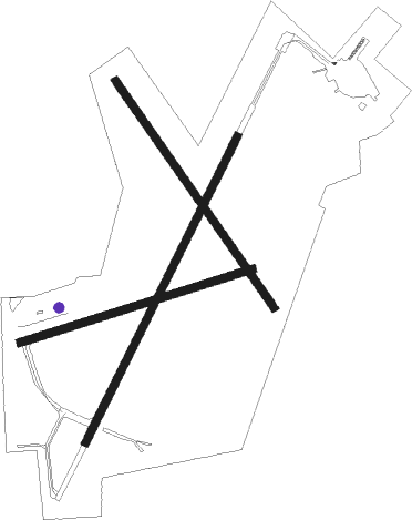
Runway info
Runway 03 / 21  | ||
| length | 789m (2589ft) | |
| bearing | 46° / 226° | |
| width | 18m (59ft) | |
| surface | asphalt | |
| displ threshold | 0m (0ft) / 74m (243ft) | |
| Runway 15 / 33 | ||
| length | 639m (2096ft) | |
| bearing | 135° / 315° | |
| width | 18m (59ft) | |
| surface | asphalt | |
| displ threshold | 86m (282ft) / 75m (246ft) | |
| Runway 08 / 26 | ||
| length | 561m (1841ft) | |
| bearing | 82° / 262° | |
| width | 18m (59ft) | |
| surface | asphalt | |
| displ threshold | 126m (413ft) / 0m (0ft) | |
Nearby beacons
| code | identifier | dist | bearing | frequency |
|---|---|---|---|---|
| HB | BELFAST CITY NDB | 6.7 | 283° | 420 |
| OY | BELFAST/ALDERGROVE NDB | 15.2 | 286° | 332 |
| BEL | BELFAST VOR/DME | 19.3 | 278° | 117.20 |
| IOM | ISLE OF MAN VOR/DME | 44.8 | 119° | 112.20 |
| MAC | MACHRIHANISH VOR/DME | 51 | 3° | 116 |
| CBL | CAMPBELTOWN NDB | 51.3 | 0° | 380 |
| TRN | TURNBERRY VOR/DME | 53.9 | 51° | 117.50 |
| GMN | GORMANSTON NDB | 59.1 | 210° | 334 |
| GMN | DME | 59.2 | 210° | 112.90 |
Disclaimer
The information on this website is not for real aviation. Use this data with the X-Plane flight simulator only! Data taken with kind consent from X-Plane 12 source code and data files. Content is subject to change without notice.