Yeovil - Rnas Yeovilton
Airport details
| Country | United Kingdom |
| State | England |
| Region | EG |
| Airspace | London Ctr |
| Municipality | South Somerset |
| Elevation | 75ft (23m) |
| Timezone | GMT +0 |
| Coordinates | 51.01472, -2.63230 |
| Magnetic var | |
| Type | land |
| Available since | X-Plane v10.40 |
| ICAO code | EGDY |
| IATA code | YEO |
| FAA code | YEO |
Communication
| RNAS Yeovilton Tower | 122.100 |
| RNAS Yeovilton RADAR | 127.350 |
Approach frequencies
| ILS-cat-I | RW26 | 111.3 | 18.00mi |
| 3° GS | RW26 | 111.3 | 18.00mi |
Nearby Points of Interest:
Church of St Bartholomew, Yeovilton
-Church of St Andrew, Northover
-Hazlegrove House
-The Abbey, Charlton Adam
-Charlton House
-Sparkford Wood
-Tintinhull Garden
-Tintinhull Court
-Abbey Farm House, Yeovil
-Abbey Barn, Yeovil
-North Cadbury Court
-Christ Church
-Brympton d'Evercy
-Abbey Farmhouse, Montacute
-Great Breach and Copley Woods
-Woolston Manor Farmhouse, And Front Boundary Wall With Railings
-Stoke sub Hamdon Priory
-Naish Priory
-Hymerford House
-The Gatehouse, Baltonsborough
-Sherborne House, Dorset
-Wet Moor
-Treasurer's House
-The Church Room
-Cary Castle
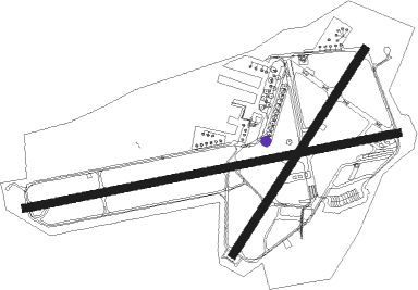
Runway info
Runway 08 / 26  | ||
| length | 2287m (7503ft) | |
| bearing | 86° / 266° | |
| width | 46m (151ft) | |
| surface | asphalt | |
| blast zone | 0m (0ft) / 21m (69ft) | |
| Runway 04 / 22 | ||
| length | 1466m (4810ft) | |
| bearing | 50° / 230° | |
| width | 46m (151ft) | |
| surface | concrete | |
Nearby beacons
| code | identifier | dist | bearing | frequency |
|---|---|---|---|---|
| VLN | YEOVILTON TACAN | 0.6 | 214° | 111 |
| YVL | YEOVIL NDB | 4.5 | 204° | 343 |
| BRI | BRISTOL NDB | 22.2 | 347° | 414 |
| EX | EXETER NDB | 29.6 | 248° | 337 |
| OF | FILTON NDB | 30.4 | 5° | 325 |
| BIA | BOURNEMOUTH NDB | 33.1 | 107° | 339 |
| BDN | BOSCOMBE DOWN TACAN | 34.1 | 81° | 108.20 |
| CDF | CARDIFF NDB | 34.9 | 298° | 388 |
| BCN | BRECON VOR/DME | 48.8 | 318° | 117.45 |
| BHD | BERRY HEAD VOR/DME | 49.4 | 234° | 112.05 |
| FFA | FAIRFORD TACAN | 50.8 | 51° | 113.40 |
| GST | GLOUCESTERSHIRE NDB | 55.4 | 28° | 331 |
Disclaimer
The information on this website is not for real aviation. Use this data with the X-Plane flight simulator only! Data taken with kind consent from X-Plane 12 source code and data files. Content is subject to change without notice.