Bodmin
Airport details
| Country | United Kingdom |
| State | England |
| Region | EG |
| Airspace | London Ctr |
| Municipality | Cornwall |
| Elevation | 625ft (190m) |
| Timezone | GMT +0 |
| Coordinates | 50.49972, -4.66583 |
| Magnetic var | |
| Type | land |
| Available since | X-Plane v10.40 |
| ICAO code | EGLA |
| IATA code | n/a |
| FAA code | n/a |
Communication
| Bodmin Bodmin radio | 122.700 |
Nearby Points of Interest:
Jubilee Rock
-Carminow Cross
-Shire Hall
-Cornwall Area of Outstanding Natural Beauty
-Bodmin Moor
-Largin Castle
-Costislost
-Tregarden
-Holy Trinity Church
-the jamaica inn
-Three Holes Cross
-Battle of Braddock Down
-Wadebridge railway station
-The Pipewell
-Fern Cottage
-Rosenannon Downs
-Phoenix United Mine
-Altarnun Methodist Chapel
-St Austell Clay Pits
-Par signal box
-Place House
-Polruan Blockhouse
-Polruan to Polperro
-Terras Pill Bridge
-Trewan Hall
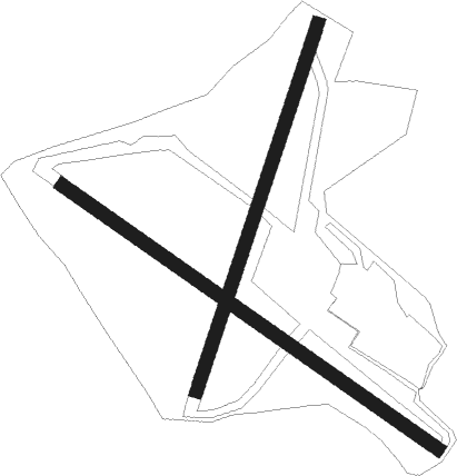
Runway info
Runway 13 / 31  | ||
| length | 612m (2008ft) | |
| bearing | 118° / 298° | |
| width | 18m (59ft) | |
| surface | grass | |
| displ threshold | 0m (0ft) / 70m (230ft) | |
| blast zone | 24m (79ft) / 0m (0ft) | |
| Runway 03 / 21 | ||
| length | 518m (1699ft) | |
| bearing | 33° / 213° | |
| width | 18m (59ft) | |
| surface | grass | |
| displ threshold | 0m (0ft) / 33m (108ft) | |
| blast zone | 27m (89ft) / 0m (0ft) | |
Nearby beacons
| code | identifier | dist | bearing | frequency |
|---|---|---|---|---|
| NQY | NEWQUAY NDB | 13.1 | 260° | 347 |
| CUL | CULDROSE NDB | 33.5 | 234° | 370 |
| LND | LANDS END VOR/DME | 43.1 | 249° | 114.20 |
Disclaimer
The information on this website is not for real aviation. Use this data with the X-Plane flight simulator only! Data taken with kind consent from X-Plane 12 source code and data files. Content is subject to change without notice.