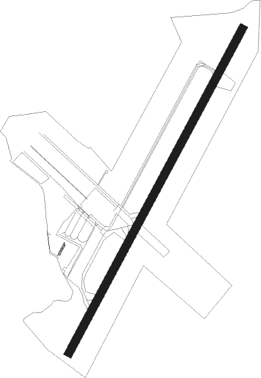
Lydd - Ashford - Lydd
Airport details
| Country | United Kingdom |
| State | England |
| Region | EG |
| Airspace | London Ctr |
| Municipality | Folkestone and Hythe District |
| Elevation | 13ft (4m) |
| Timezone | GMT +0 |
| Coordinates | 50.95611, 0.93917 |
| Magnetic var | |
| Type | land |
| Available since | X-Plane v10.40 |
| ICAO code | EGMD |
| IATA code | LYX |
| FAA code | n/a |
Communication
| Lydd Lydd Information | 129.230 |
| Lydd Lydd Tower | 119.380 |
| Lydd Lydd Approach | 120.705 |
Approach frequencies
| ILS-cat-I | RW21 | 108.15 | 18.00mi |
| 3.5° GS | RW21 | 108.15 | 18.00mi |
Nearby Points of Interest:
Dungeness, Romney Marsh and Rye Bay
-Houghton Green Cliff
-Rye Harbour Nature Reserve
-Leacon Hall
-Rye Particular Baptist Chapel
-Gibbet Mill
-Centuries, Hythe
-The Town Hall
-Lower Mill
-Hatch Park
-Spade House
-Folkestone War Memorial
-The Guildhall
-Folkestone Lighthouse
-SM U-8
-Great Maytham Hall
-Rolvenden War Memorial
-Shrub's Wood Long Barrow
-Rolvenden Windmill
-Wye College
-Windycroft
-Davison's Mill, Stelling Minnis
-Royal Military Canal
-East Hill Cliff Railway
-St Mary's Church, Capel-le-Ferne
Nearby beacons
| code | identifier | dist | bearing | frequency |
|---|---|---|---|---|
| LZD | LYDD NDB | 0.1 | 3° | 397 |
| LYD | LYDD VOR/DME | 3.4 | 306° | 114.05 |
| HLS | DME | 16.1 | 304° | 115.95 |
| LSH | HEADCORN (LASHENDEN) NDB | 16.1 | 304° | 340 |
| DVR | DOVER VOR/DME | 20.1 | 64° | 114.95 |
| DET | DETLING VOR/DME | 24.5 | 315° | 117.30 |
| ING | SAINT INGLEVERT NDB | 30.7 | 95° | 387 |
| MAY | MAYFIELD VOR/DME | 31.3 | 274° | 117.90 |
| SFD | SEAFORD VOR/DME | 33.1 | 257° | 117 |
| SND | SOUTHEND NDB | 38.2 | 339° | 362 |
| BIG | BIGGIN VOR/DME | 40.8 | 293° | 115.10 |
| BNE | BOULOGNE SUR MER VOR | 41.7 | 109° | 113.80 |
| LCY | LONDON CITY NDB | 46.4 | 302° | 322 |
| SRH | DME-ILS | 47.2 | 264° | 109.95 |
| SHM | SHOREHAM NDB | 47.3 | 264° | 332 |
| LAM | LAMBOURNE VOR/DME | 50.9 | 311° | 115.60 |
| EPM | EPSOM NDB | 54 | 285° | 316 |
| CLN | CLACTON VOR/DME | 54.1 | 13° | 114.55 |
| OCK | OCKHAM VOR/DME | 56.2 | 284° | 115.30 |
| MID | MIDHURST VOR/DME | 59.4 | 274° | 114 |
| ABB | ABBEVILLE VOR/DME | 60.4 | 132° | 108.45 |
| BPK | BROOKMANS PARK VOR/DME | 61.7 | 307° | 117.50 |
| LON | LONDON VOR/DME | 61.7 | 291° | 113.60 |
| GWC | GOODWOOD VOR/DME | 64.5 | 267° | 114.75 |
| CHT | CHILTERN NDB | 67.8 | 295° | 277 |
| BUR | BURNHAM NDB | 69.5 | 289° | 421 |
| BLC | DME | 70.7 | 282° | 116.20 |
| BLK | BLACKBUSHE NDB | 70.7 | 282° | 328 |
| LUT | LUTON NDB | 71.8 | 308° | 345 |
| BNN | BOVINGDON VOR/DME | 72.5 | 297° | 113.75 |
| ODH | ODIHAM TACAN | 73.1 | 278° | 109.60 |
| WOD | WOODLEY NDB | 74.6 | 285° | 352 |
Instrument approach procedures
| runway | airway (heading) | route (dist, bearing) |
|---|---|---|
| RW03 | GOKAT (50°) | GOKAT 2500ft |
| RW03 | PEVOL (18°) | PEVOL 2500ft GOKAT (5mi, 296°) 2500ft |
| RW03 | RIBGO (73°) | RIBGO 2500ft GOKAT (5mi, 116°) 2500ft |
| RNAV | GOKAT 2500ft MD03F (5mi, 51°) 1600ft MA03 (4mi, 51°) 306ft DINBI (6mi, 286°) GOKAT (10mi, 180°) 2500ft GOKAT (turn) 2500ft | |
| RW21-Y | GITKI (231°) | GITKI 3200ft TUMVA (4mi, 282°) 3200ft MD21F (5mi, 208°) 2700ft |
| RW21-Y | SORDI (183°) | SORDI 3200ft TUMVA (4mi, 102°) 3200ft MD21F (5mi, 208°) 2700ft |
| RW21-Y | TUMVA (210°) | TUMVA 3200ft MD21F (5mi, 208°) 2700ft |
| RNAV | MD21F 2700ft MA21 (6mi, 208°) 428ft BEMLA (9mi, 309°) ROMTI (5mi, 118°) 3200ft ROMTI (turn) 3200ft | |
| RW21-Z | BEGTI (235°) | BEGTI 3200ft NURSI (5mi, 282°) 3200ft GATSU (5mi, 208°) 2800ft |
| RW21-Z | LONRU (179°) | LONRU 3200ft NURSI (5mi, 102°) 3200ft GATSU (5mi, 208°) 2800ft |
| RW21-Z | NURSI (211°) | NURSI 3200ft GATSU (5mi, 208°) 2800ft |
| RNAV | GATSU 2800ft MA21C (6mi, 208°) 597ft BEMLA (8mi, 306°) ROMTI (5mi, 118°) 3200ft ROMTI (turn) 3200ft |
Disclaimer
The information on this website is not for real aviation. Use this data with the X-Plane flight simulator only! Data taken with kind consent from X-Plane 12 source code and data files. Content is subject to change without notice.
