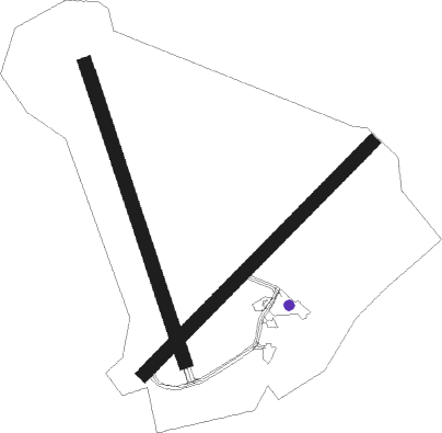
Barrow-in-furness - Barrow Walney Island
Airport details
| Country | United Kingdom |
| State | England |
| Region | EG |
| Airspace | London Ctr |
| Municipality | Barrow-in-Furness |
| Elevation | 42ft (13m) |
| Timezone | GMT +0 |
| Coordinates | 54.12861, -3.26750 |
| Magnetic var | |
| Type | land |
| Available since | X-Plane v10.40 |
| ICAO code | EGNL |
| IATA code | BWF |
| FAA code | n/a |
Communication
| Barrow Walney Island Tower | 123.200 |
| Barrow Walney Island Departure (Manchester Center) | 118.775 |
Approach frequencies
| ILS-cat-I | RW35 | 110.15 | 18.00mi |
| 3.5° GS | RW35 | 110.15 | 18.00mi |
Nearby beacons
| code | identifier | dist | bearing | frequency |
|---|---|---|---|---|
| WL | BARROW (WALNEY ISLAND) NDB | 0.1 | 111° | 385 |
| BPL | BLACKPOOL NDB | 22.9 | 146° | 318 |
| WTN | WARTON TACAN | 26.8 | 135° | 113.20 |
| WTN | WARTON NDB | 26.9 | 132° | 337 |
| DCS | CROSS DME | 35.7 | 353° | 115.20 |
| DUF | DUN FELL DME | 43.8 | 56° | 115.25 |
| WAL | WALLASEY VOR/DME | 44.4 | 170° | 114.10 |
| LPL | LIVERPOOL NDB | 51.1 | 145° | 349 |
| HAW | HAWARDEN NDB | 57.9 | 163° | 340 |
| WHI | WHITEGATE NDB | 61.1 | 146° | 368 |
Instrument approach procedures
| runway | airway (heading) | route (dist, bearing) |
|---|---|---|
| RW17 | BEGPU (185°) | BEGPU 4000ft NL17I (3mi, 262°) 3000ft |
| RW17 | USADI (125°) | USADI 3000ft NL01A (3mi, 49°) 3000ft NL17I (2mi, 82°) 3000ft |
| RNAV | NL17I 3000ft NL17F (3mi, 157°) 2500ft EGNL (7mi, 157°) 72ft NLM01 (4mi, 157°) NLM02 (4mi, 262°) NLM05 (4mi, 317°) 3000ft NLM05 (turn) | |
| RW35 | IBREM (10°) | IBREM 2200ft NL35I (3mi, 82°) 1900ft |
| RW35 | UVNUB (337°) | UVNUB 1900ft NL35I (3mi, 337°) 1900ft |
| RW35 | VAGVI (311°) | VAGVI 2300ft NL35I (3mi, 262°) 1900ft |
| RNAV | NL35I 1900ft NL35F (3mi, 337°) 1900ft EGNL (5mi, 337°) 77ft NLM03 (4mi, 337°) NLM04 (3mi, 262°) NLM05 (4mi, 202°) 3000ft NLM05 (turn) |
Disclaimer
The information on this website is not for real aviation. Use this data with the X-Plane flight simulator only! Data taken with kind consent from X-Plane 12 source code and data files. Content is subject to change without notice.

