Deventer - Teuge
Airport details
| Country | Netherlands |
| State | Gelderland |
| Region | EH |
| Airspace | Amsterdam Ctr |
| Municipality | Teuge |
| Elevation | 17ft (5m) |
| Timezone | GMT +1 |
| Coordinates | 52.24472, 6.04667 |
| Magnetic var | |
| Type | land |
| Available since | X-Plane v10.40 |
| ICAO code | EHTE |
| IATA code | n/a |
| FAA code | n/a |
Communication
| Teuge Teuge Radio | 121.005 |
Nearby Points of Interest:
Martinuskerk, Twello
-Het Wezeveld
-De Rechthoek
-De Flierkamp
-Koudhoornse sluis
-Apeldoornsche Bosch
-Kerk Terwolde
-Marialust
-Prinsenpark, Apeldoorn
-Het Schol
-Vaassense sluis
-Station Vaassen
-Seyss-Inquart's bunker, Apeldoorn
-Hervormdekapel Deventer
-Royal Stables, Het Loo Palace
-Mariakerk
-Stappenconvent Deventer
-Latin School
-City Hall, Deventer
-Vindplaats Vloeislakken Orderbos
-De Drie Haringen
-Waag, Deventer
-Penninckshuis (Deventer)
-Nederlands Hervormde Kerk
-Brink 12, Deventer
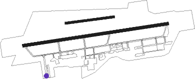
Runway info
Runway 08 / 26  | ||
| length | 1196m (3924ft) | |
| bearing | 87° / 267° | |
| width | 27m (89ft) | |
| surface | asphalt | |
| Runway 08L / 26R | ||
| length | 394m (1293ft) | |
| bearing | 88° / 268° | |
| width | 18m (60ft) | |
| surface | grass | |
Nearby beacons
| code | identifier | dist | bearing | frequency |
|---|---|---|---|---|
| DLN | DEELEN TACAN | 12.9 | 223° | 112.20 |
| FRO | DME | 23.3 | 291° | 111.40 |
| RKN | DME | 27.2 | 99° | 116.80 |
| PAM | PAMPUS VOR/DME | 35.4 | 275° | 117.80 |
| VKL | VOLKEL TACAN | 37.5 | 210° | 108.30 |
| NID | DME | 38.8 | 172° | 115.50 |
| LAA | NIEDERRHEIN NDB | 38.9 | 169° | 352 |
| BOT | BOTTROP NDB | 53.6 | 124° | 406 |
| EHV | EINDHOVEN TACAN | 53.9 | 220° | 117.20 |
| LMA | LIMA NDB | 54 | 158° | 311 |
| EEL | EELDE (GRONINGEN) VOR/DME | 59.6 | 34° | 112.40 |
| LWD | LEEUWARDEN TACAN | 59.7 | 343° | 114.70 |
| LI | DUESSELDORF NDB | 62.3 | 137° | 417 |
| DUS | DUESSELDORF VOR/DME | 63.4 | 144° | 115.15 |
Instrument approach procedures
| runway | airway (heading) | route (dist, bearing) |
|---|---|---|
| RW26 | DEVUT (268°) | DEVUT 3000ft TE400 (4mi, 267°) 3000ft |
| RNAV | TE400 3000ft EHTE (8mi, 268°) 55ft TE401 (1mi, 264°) DEVUT (13mi, 87°) 3000ft |
Disclaimer
The information on this website is not for real aviation. Use this data with the X-Plane flight simulator only! Data taken with kind consent from X-Plane 12 source code and data files. Content is subject to change without notice.