Baldonnel - Casement Ab
Airport details
| Country | Ireland |
| State | County Dublin |
| Region | EI |
| Airspace | Shannon Ctr |
| Municipality | South Dublin |
| Elevation | 316ft (96m) |
| Timezone | GMT +0 |
| Coordinates | 53.30601, -6.44111 |
| Magnetic var | |
| Type | land |
| Available since | X-Plane v10.40 |
| ICAO code | EIME |
| IATA code | n/a |
| FAA code | n/a |
Communication
| Casement AB Baldonnel Information | 122.805 |
| Casement AB Baldonnel Ground | 121.755 |
| Casement AB Baldonnel Tower | 123.500 |
| Casement AB Baldonnel Approach | 122.000 |
Approach frequencies
| ILS-cat-I | RW10 | 109.35 | 18.00mi |
| 3° GS | RW10 | 109.35 | 18.00mi |
Nearby Points of Interest:
St. Mary's Abbey, Dublin
-St. Mark's Cross
-Kilruddery House
-Hill of Tara
-Balrath Cross
-Dwyer–McAllister Cottage
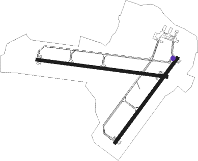
Runway info
Runway 10 / 28  | ||
| length | 1823m (5981ft) | |
| bearing | 97° / 277° | |
| width | 46m (151ft) | |
| surface | asphalt | |
| displ threshold | 0m (0ft) / 183m (600ft) | |
| Runway 04 / 22 | ||
| length | 1460m (4790ft) | |
| bearing | 55° / 235° | |
| width | 46m (151ft) | |
| surface | asphalt | |
Nearby beacons
| code | identifier | dist | bearing | frequency |
|---|---|---|---|---|
| BAL | BALDONNEL VOR/DME | 0.4 | 227° | 115.80 |
| OE | DUBLIN NDB | 7.4 | 6° | 316 |
| DAP | COLLINSTOWN VOR/DME | 8.6 | 50° | 111.20 |
| KLY | KILLINEY NDB | 12.2 | 96° | 378 |
| DUB | DUBLIN VOR/DME | 12.5 | 35° | 114.90 |
| OP | DUBLIN NDB | 12.6 | 70° | 397 |
| GMN | DME | 21.7 | 31° | 112.90 |
| GMN | GORMANSTON NDB | 21.9 | 32° | 334 |
| GTG | DME | 29.2 | 147° | 114.15 |
| MCM | DME | 39.8 | 323° | 114.40 |
Departure and arrival routes
| Transition altitude | 5000ft |
| STAR starting points | distance | inbound heading | |
|---|---|---|---|
| RW22 | |||
| OLAP1K | 41.7 | 119° | |
| BAML1K | 50.7 | 166° | |
| NIMA1K | 46.7 | 227° | |
| BOYN1K | 43.5 | 244° | |
| BAGS1K | 40.4 | 248° | |
| RW28 | |||
| BUNE1S | 41.5 | 15° | |
| SUTE1S | 33.8 | 45° | |
| OSGA1S | 33.5 | 73° | |
| LIPG1S | 36.8 | 284° | |
| VATR1S | 56.5 | 309° | |
Holding patterns
| STAR name | hold at | type | turn | heading* | altitude | leg | speed limit |
|---|---|---|---|---|---|---|---|
| BAGS1K | KERAV | VHF | right | 28 (208)° | 5000ft - 14000ft | 1.0min timed | 230 |
| BAML1K | KERAV | VHF | right | 28 (208)° | 5000ft - 14000ft | 1.0min timed | 230 |
| BOYN1K | KERAV | VHF | right | 28 (208)° | 5000ft - 14000ft | 1.0min timed | 230 |
| BUNE1S | SORIN | VHF | left | 165 (345)° | 5000ft - 14000ft | 1.0min timed | 230 |
| LIPG1S | SORIN | VHF | left | 165 (345)° | 5000ft - 14000ft | 1.0min timed | 230 |
| NIMA1K | KERAV | VHF | right | 28 (208)° | 5000ft - 14000ft | 1.0min timed | 230 |
| OLAP1K | KERAV | VHF | right | 28 (208)° | 5000ft - 14000ft | 1.0min timed | 230 |
| OSGA1S | SORIN | VHF | left | 165 (345)° | 5000ft - 14000ft | 1.0min timed | 230 |
| SUTE1S | SORIN | VHF | left | 165 (345)° | 5000ft - 14000ft | 1.0min timed | 230 |
| VATR1S | SORIN | VHF | left | 165 (345)° | 5000ft - 14000ft | 1.0min timed | 230 |
| *) magnetic outbound (inbound) holding course | |||||||
Disclaimer
The information on this website is not for real aviation. Use this data with the X-Plane flight simulator only! Data taken with kind consent from X-Plane 12 source code and data files. Content is subject to change without notice.