Herning
Airport details
| Country | Denmark |
| State | Central Denmark Region |
| Region | EK |
| Airspace | Copenhagen Ctr |
| Municipality | Herning Municipality |
| Elevation | 166ft (51m) |
| Timezone | GMT +1 |
| Coordinates | 56.18475, 9.04445 |
| Magnetic var | |
| Type | land |
| Available since | X-Plane v10.40 |
| ICAO code | EKHG |
| IATA code | n/a |
| FAA code | n/a |
Communication
| Herning Herning Radio | 121.000 |
| Herning Karup Approach | 120.425 |
Nearby Points of Interest:
Højris
-Tvis Abbey
-Hald Manor
-Silkeborg Hovedgård
-Palstrup
-Remisen
-Domprovstegården
-Svaneapoteket
-Den lille gård på Torvet
-Stillings Gård
-Friedenreichs Gård
-Generalkommandoen
-Skolestræde 2
-Latinskolen
-Skolestræde 1
-Salomon Gerbers Gård
-Bispegården
-Gamle Vagt
-Sankt Mogensgade 7
-Morvilles Gård
-Villadsens Gård
-Sankt Mogensgade 11
-Exercerhuset
-Asmild Runestone
-Det Zahrtmannske Hus
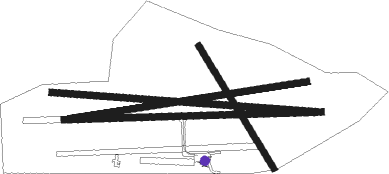
Runway info
Runway 09 / 27  | ||
| length | 1200m (3937ft) | |
| bearing | 92° / 272° | |
| width | 30m (98ft) | |
| surface | asphalt | |
| Runway 09S / 27 | ||
| length | 1294m (4245ft) | |
| bearing | 95° / 275° | |
| width | 30m (98ft) | |
| surface | grass | |
| Runway 15 / 33 | ||
| length | 668m (2192ft) | |
| bearing | 138° / 318° | |
| width | 30m (98ft) | |
| surface | grass | |
| displ threshold | 120m (394ft) / 130m (427ft) | |
Nearby beacons
| code | identifier | dist | bearing | frequency |
|---|---|---|---|---|
| KAR | KARUP TACAN | 6.8 | 342° | 110 |
| VJ | STAUNING NDB | 23.8 | 252° | 328 |
| LME | DME | 25.8 | 254° | 115.35 |
| AU | STAUNING NDB | 26.9 | 255° | 346 |
| RAM | DME | 33.5 | 289° | 111.85 |
| EJ | ESBJERG NDB | 40.3 | 208° | 400 |
| ESE | DME | 43 | 216° | 116.60 |
| KD | KOLDING NDB | 45.5 | 159° | 357 |
| HP | ESBJERG NDB | 45.7 | 223° | 376 |
| VAM | DME | 45.9 | 159° | 110.05 |
| SKR | VOJENS/SKRYDSTRUP VORTAC | 57.6 | 170° | 110.40 |
| VO | VOJENS/SKRYDSTRUP NDB | 58.1 | 167° | 321 |
| AAL | AALBORG VORTAC | 63.5 | 46° | 116.70 |
Disclaimer
The information on this website is not for real aviation. Use this data with the X-Plane flight simulator only! Data taken with kind consent from X-Plane 12 source code and data files. Content is subject to change without notice.