Aars - Vesthimmerland
Airport details
| Country | Denmark |
| State | North Denmark Region |
| Region | EK |
| Airspace | Copenhagen Ctr |
| Municipality | Vesthimmerland Municipality |
| Elevation | 119ft (36m) |
| Timezone | GMT +1 |
| Coordinates | 56.84750, 9.46000 |
| Magnetic var | |
| Type | land |
| Available since | X-Plane v10.40 |
| ICAO code | EKVH |
| IATA code | n/a |
| FAA code | n/a |
Communication
| Vesthimmerland Vesthimmerland Radio | 122.225 |
| Vesthimmerland AALBORG Approach | 123.975 |
Nearby Points of Interest:
Flejsborg-stenen
-Giver runestone
-Skivum Runic Stone
-Farsø-stenen
-Lerkenfeld
-Suldrup-stenen
-Lundbæk
-Aggersborggård
-Ravnkilde-stenen 1
-Rold Skov
-langdysse ved Skræm
-Ferslev-stenen 1
-H.I. Bies Bryggeri
-Hobro-stenen 2
-Ørslev Kloster
-Lynderupgård
-Gunderup-stenen 2
-Gunderup Runestone 1
-Lyngby-stenen
-Lundby Bakker Hellekiste
-Aalborg Post og Telegraf
-Jens Bang's House
-Jørgen Olufsen's House
-Tårupgård
-Vester Tørslev stone
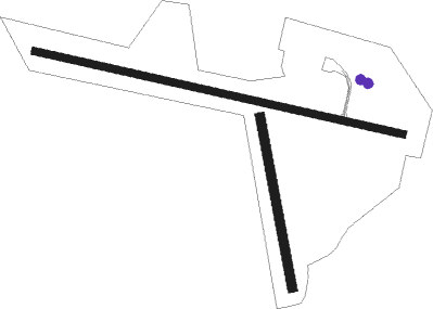
Runway info
Runway 11 / 29  | ||
| length | 1199m (3934ft) | |
| bearing | 100° / 280° | |
| width | 23m (75ft) | |
| surface | asphalt | |
| displ threshold | 150m (492ft) / 150m (492ft) | |
| Runway 17 / 35 | ||
| length | 551m (1808ft) | |
| bearing | 169° / 349° | |
| width | 30m (98ft) | |
| surface | grass | |
Nearby beacons
| code | identifier | dist | bearing | frequency |
|---|---|---|---|---|
| AAL | AALBORG VORTAC | 23.3 | 64° | 116.70 |
| KAR | KARUP TACAN | 36.2 | 219° | 110 |
| SD | SINDAL NDB | 45.2 | 47° | 339 |
Disclaimer
The information on this website is not for real aviation. Use this data with the X-Plane flight simulator only! Data taken with kind consent from X-Plane 12 source code and data files. Content is subject to change without notice.