Hattfjelldal
Airport details
| Country | Norway |
| State | Nordland |
| Region | EN |
| Airspace | Polaris Ctr |
| Municipality | Hattfjelldal |
| Elevation | 687ft (209m) |
| Timezone | GMT +1 |
| Coordinates | 65.59472, 13.98917 |
| Magnetic var | |
| Type | land |
| Available since | X-Plane v10.40 |
| ICAO code | ENHT |
| IATA code | n/a |
| FAA code | n/a |
Communication
Nearby Points of Interest:
Susendal Church
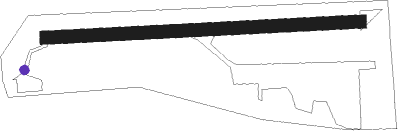
Runway info
| Runway 09 / 27 | ||
| length | 721m (2365ft) | |
| bearing | 91° / 271° | |
| width | 30m (98ft) | |
| surface | concrete | |
| displ threshold | 30m (98ft) / 60m (197ft) | |
Nearby beacons
| code | identifier | dist | bearing | frequency |
|---|---|---|---|---|
| LR | LAKSFORS NDB | 17.2 | 272° | 335 |
| MS | MOSJOEN NDB | 22.7 | 288° | 324 |
| MOS | MOSJOEN TACAN | 23.8 | 293° | 113.90 |
| VFL | VARDEFJELL VOR/DME | 23.9 | 293° | 113.30 |
| STM | STROMMEN NDB | 42.1 | 342° | 345 |
| GR | GRUBEN (MO I RANA) NDB | 44 | 17° | 368 |
Disclaimer
The information on this website is not for real aviation. Use this data with the X-Plane flight simulator only! Data taken with kind consent from X-Plane 12 source code and data files. Content is subject to change without notice.