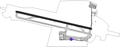
Poznań - Poznan Lawica
Airport details
| Country | Poland |
| State | Greater Poland Voivodeship |
| Region | EP |
| Airspace | Warsaw Ctr |
| Municipality | Poznań |
| Elevation | 308ft (94m) |
| Timezone | GMT +1 |
| Coordinates | 52.42034, 16.84357 |
| Magnetic var | |
| Type | land |
| Available since | X-Plane v10.40 |
| ICAO code | EPPO |
| IATA code | POZ |
| FAA code | n/a |
Communication
| Poznan Lawica RADIO | 119.975 |
Approach frequencies
| ILS-cat-I | RW28 | 110.3 | 18.00mi |
| 3° GS | RW28 | 110.3 | 18.00mi |
Runway info
| Runway 10 / 28 | ||
| length | 2507m (8225ft) | |
| bearing | 101° / 281° | |
| width | 50m (164ft) | |
| surface | asphalt | |
Nearby beacons
| code | identifier | dist | bearing | frequency |
|---|---|---|---|---|
| LAW | LAWICA (POZNAN) VOR/DME | 0.5 | 279° | 115.80 |
| TKS | KRZESINY (POZNAN) TACAN | 6.9 | 125° | 111.50 |
| NK | KRZESINY (POZNAN) NDB | 8.1 | 123° | 489 |
| CMP | CZEMPIN VOR/DME | 17.8 | 203° | 114.50 |
| NA | MIROSLAWIEC NDB | 63.6 | 323° | 297 |
| TMI | MIROSLAWIEC TACAN | 65.2 | 322° | 115.35 |
Departure and arrival routes
| Transition altitude | 6500ft |
| SID end points | distance | outbound heading | |
|---|---|---|---|
| RW10 | |||
| DEKU1H | 42mi | 15° | |
| OBOK1H | 44mi | 98° | |
| XIDN1H | 44mi | 168° | |
| ERNO1H | 38mi | 244° | |
| ELSU1H | 53mi | 275° | |
| XERB1H | 56mi | 298° | |
| RW28 | |||
| DEKU1B | 42mi | 15° | |
| OBOK1B | 44mi | 98° | |
| XIDN1B | 44mi | 168° | |
| ERNO1B | 38mi | 244° | |
| ELSU1B | 53mi | 275° | |
| XERB1B | 56mi | 298° | |
| STAR starting points | distance | inbound heading | |
|---|---|---|---|
| RW10 | |||
| AKAP1T | 33.0 | 37° | |
| KELO1T | 36.9 | 79° | |
| DENK1T | 43.8 | 111° | |
| DEKU1T | 42.3 | 195° | |
| MASI1T | 44.6 | 292° | |
| NILP1T | 30.6 | 325° | |
| RW28 | |||
| CMP1D | 17.8 | 23° | |
| AKAP1M | 33.0 | 37° | |
| KELO1M | 36.9 | 79° | |
| DENK1M | 43.8 | 111° | |
| DEKU1M | 42.3 | 195° | |
| MASI1M | 44.6 | 292° | |
| NILP1M | 30.6 | 325° | |
Instrument approach procedures
| runway | airway (heading) | route (dist, bearing) |
|---|---|---|
| RW10 | OBELI (100°) | OBELI 3000ft PO602 (3mi, 101°) PO601 (2mi, 101°) 2000ft |
| RNAV | PO601 2000ft EPPO (7mi, 100°) 358ft PO611 (15mi, 101°) PO612 (7mi, 208°) PO632 (11mi, 265°) 4000ft | |
| RW28 | NUNBI (282°) | NUNBI 3000ft PO702 (1mi, 281°) PO701 (2mi, 281°) 2800ft |
| RNAV | PO701 2800ft PO699 (5mi, 281°) 1080ft EPPO (2mi, 283°) 338ft PO711 (12mi, 280°) PO712 (7mi, 208°) PO707 (7mi, 139°) 4000ft |
Holding patterns
| STAR name | hold at | type | turn | heading* | altitude | leg | speed limit |
|---|---|---|---|---|---|---|---|
| AKAP1M | AKAPI | VHF | right | 187 (7)° | > 10000ft | 1.0min timed | 230 |
| AKAP1T | AKAPI | VHF | right | 187 (7)° | > 10000ft | 1.0min timed | 230 |
| DEKU1M | PO742 | VHF | right | 5 (185)° | > 10000ft | 1.0min timed | 230 |
| DEKU1T | BAISA | VHF | right | 284 (104)° | > 10000ft | 1.0min timed | 230 |
| DENK1M | PO742 | VHF | right | 5 (185)° | > 10000ft | 1.0min timed | 230 |
| DENK1M | PO743 | VHF | right | 272 (92)° | > 10000ft | 1.0min timed | 230 |
| DENK1T | BAISA | VHF | right | 284 (104)° | > 10000ft | 1.0min timed | 230 |
| KELO1M | KELOD | VHF | right | 277 (97)° | 35000ft - 46000ft | 1.5min timed | ICAO rules |
| KELO1T | KELOD | VHF | right | 277 (97)° | 35000ft - 46000ft | 1.5min timed | ICAO rules |
| MASI1M | PO732 | VHF | right | 103 (283)° | > 10000ft | 1.0min timed | 230 |
| MASI1T | PO633 | VHF | right | 103 (283)° | > 10000ft | 1.0min timed | 230 |
| NILP1M | NILPU | VHF | right | 139 (319)° | > 10000ft | 1.0min timed | 230 |
| NILP1T | NILPU | VHF | right | 139 (319)° | > 10000ft | 1.0min timed | 230 |
| *) magnetic outbound (inbound) holding course | |||||||
Disclaimer
The information on this website is not for real aviation. Use this data with the X-Plane flight simulator only! Data taken with kind consent from X-Plane 12 source code and data files. Content is subject to change without notice.
