Airports for X-Plane offers a convenient way to explore airports and their related communication information for the X-Plane flight simulator. It only uses data from the X-Plane flight simulator itself, and is therefore more reliable than the data that comes from real aviation websites. You can search for airports by using the ICAO code, or browse for airports per country and state. The information displayed is categorized by airport details, runway information, airport communication, approach frequencies (ILS and Glidepath details), details of nearby beacons, SIDs, STARs and approach procedures.

airplane capital road pilot frankfurt airport grass jet hospital control tower customs taxi stolport asphalt airport apron airliner arrival heliport terminal bus passenger

Rudniki - Czestochowa Rudniki

Airport details

CountryPoland
StateSilesian Voivodeship
RegionEP
AirspaceWarsaw Ctr
Municipalitygmina Rędziny
Elevation817ft (249m)
TimezoneGMT +1
Coordinates50.88633, 19.20247
Magnetic var
Typeland
Available sinceX-Plane v10.40
ICAO codeEPRU
IATA coden/a
FAA coden/a

Communication

CZESTOCHOWA RUDNIKI Rudniki Radio122.800
Nearby Points of Interest:
Werszczyński manor in Kościelec
-
Parish cemetery in Rędziny
-
Saint Leonard church in Mykanów
-
Palace in Borowno
-
Palace in Nieznanice
-
Monastery of Canons Regular in Wancerzów
-
Kościół św. Barbary w Starej Częstochowie
-
Hoffman's Villa in Częstochowa
-
8 Strażacka Street in Częstochowa
-
Former brewery in Częstochowa
-
34 Saint Mary Avenue in Częstochowa
-
24 Saint Mary Avenue in Częstochowa
-
Biegański House
-
47 Saint Mary Avenue in Częstochowa
-
22 Kopernika Street in Częstochowa
-
Protestant cemetery in Częstochowa
-
Saint Anthony of Padua church in Częstochowa
-
Hantke Villa in Częstochowa
-
Manor in Rzeki Wielkie
-
Church of St. John the Baptist in Olsztyn
-
Manor in Bukowno
-
Our Lady of Sorrows church in Gidle
-
Manor house in Czepurka
-
Saint John the Baptist church in Nowa Brzeźnica
-
Saint John the Baptist church in Choroń

Runway info

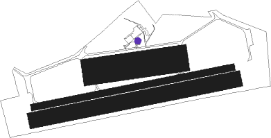
Runway 08 / 26  
 length1802m (5912ft)
 bearing86° / 266°
 width60m (197ft)
 surfaceconcrete
 blast zone0m (0ft) / 190m (623ft)
Runway 08L / 26R  
 length720m (2362ft)
 bearing88° / 268°
 width240m (787ft)
 surfacegrass
Runway 08R / 26L  
 length1802m (5912ft)
 bearing86° / 266°
 width140m (459ft)
 surfacegrass

Airport layout - parking location GA1


Parking locations

Nearby beacons

codeidentifierdistbearingfrequency
KAXKATOWICE VOR/DME24.9196°114.80
WIEDME26.7270°109.65
TASLASK TACAN39.8358°108.55
KAKKRAKOW VOR/DME53.5144°112.80
TTMTOMASZOW MAZOWIECKI TACAN53.852°110.70
NPTOMASZOW MAZOWIECKI NDB5453°437
NPRTOMASZOW MAZOWIECKI NDB54.455°488
PSZDME55.3201°116.90
LOZWIACZYN DOLNY VOR/DME55.725°112.40

Disclaimer

The information on this website is not for real aviation. Use this data with the X-Plane flight simulator only! Data taken with kind consent from X-Plane 12 source code and data files. Content is subject to change without notice.