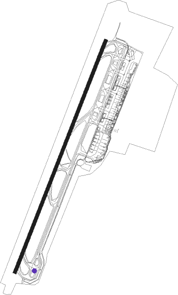
Gothenburg - Göteborg Landvetter
Airport details
| Country | Sweden |
| State | Västra Götalands län |
| Region | ES |
| Airspace | Sweden Ctr |
| Municipality | Härryda kommun |
| Elevation | 501ft (153m) |
| Timezone | GMT +1 |
| Coordinates | 57.66000, 12.29111 |
| Magnetic var | |
| Type | land |
| Available since | X-Plane v10.40 |
| ICAO code | ESGG |
| IATA code | GOT |
| FAA code | n/a |
Communication
| Göteborg Landvetter ATIS | 114.600 |
| Göteborg Landvetter ATIS | 118.375 |
| Göteborg Landvetter Ground | 121.900 |
| Göteborg Landvetter Apron Pushback | 121.600 |
| Göteborg Landvetter LANDVETTER Tower | 118.600 |
| Göteborg Landvetter GOTEBORG Approach | 124.675 |
Approach frequencies
| ILS-cat-III | RW21 | 108.5 | 18.00mi |
| ILS-cat-III | RW03 | 110.3 | 18.00mi |
| 3° GS | RW21 | 108.5 | 18.00mi |
| 3° GS | RW03 | 110.3 | 18.00mi |
Nearby Points of Interest:
Härryda socken
-Landvetters socken
-Aspenkyrkan
-Hindås kyrka
-Råda socken
-Björketorps socken
-Lerum parish
-Lindome socken
-Stenkullens kyrka
-Hillefors grynkvarn
-Kållereds socken
-Stensjökyrkan
-Fågelbergskyrkan
-Mölndals Kvarnby
-Bollebygd socken
-Bollebygdsklockan
-Sätila socken
-Konung Rings gravsten
-Mölndals stad
-Älvsåkers socken
-Fässbergs socken
-Skallsjö socken
-Bergsjöns kyrka
-Villa Soltorpet
-Härlanda fängelse
Nearby beacons
| code | identifier | dist | bearing | frequency |
|---|---|---|---|---|
| LAV | LANDVETTER (GOTEBORG) VOR/DME | 0.2 | 198° | 114.60 |
| NL | LANDVETTER (GOTEBORG) NDB | 4.5 | 37° | 369 |
| SL | LANDVETTER (GOTEBORG) NDB | 4.5 | 227° | 342 |
| HGG | DME | 4.8 | 165° | 113.95 |
| PGG | DME | 5.3 | 307° | 113.35 |
| BAK | DME | 11.9 | 252° | 112.70 |
| SDH | DME | 18.6 | 80° | 115.65 |
| PG | TROLLHATTAN-VANERSBORG NDB | 36.4 | 12° | 325 |
| FM | TROLLHATTAN-VANERSBORG NDB | 42 | 360° | 399 |
| SG | SATENAS NDB | 45.2 | 30° | 409 |
| LG | SATENAS NDB | 49.5 | 28° | 309 |
| LT | HALMSTAD NDB | 54.8 | 147° | 336 |
Departure and arrival routes
| Transition altitude | 5000ft |
| SID end points | distance | outbound heading | |
|---|---|---|---|
| RW03 | |||
| NEGI3M | 37mi | 29° | |
| LABA3M | 44mi | 63° | |
| LUKA3M | 28mi | 86° | |
| TOPL3M, SOJW1P | 32mi | 175° | |
| VADI3M | 38mi | 231° | |
| TAKO3R, DETN3M | 40mi | 267° | |
| SABA3M, TISA3R | 37mi | 309° | |
| RW21 | |||
| SULI3J, NEGI2G | 37mi | 29° | |
| LABA4J | 44mi | 63° | |
| MISV3P | 16mi | 68° | |
| LUKA4J | 28mi | 86° | |
| TOPL3J | 32mi | 175° | |
| VADI3J | 38mi | 231° | |
| DETN3J | 40mi | 267° | |
| PEVA2G | 16mi | 284° | |
| SABA3J | 37mi | 309° | |
| STAR starting points | distance | inbound heading | |
|---|---|---|---|
| RW03 | |||
| RISM3K, RISM4L | 38.4 | 27° | |
| LOBI4K, LOBI5L | 32.8 | 67° | |
| MAKU5L, MAKU4K | 31.6 | 75° | |
| KELI3L, KELI3K | 35.8 | 158° | |
| NEGI3K, NEGI3L | 37.0 | 209° | |
| MOXA3K, MOXA3L | 61.5 | 230° | |
| ARQU1L, ARQU1Q | 39.6 | 312° | |
| RW21 | |||
| RISM3T, RISM3S | 38.4 | 27° | |
| LOBI4T, LOBI4S | 32.8 | 67° | |
| MAKU4S, MAKU4T | 31.6 | 75° | |
| KELI3T, KELI3S | 35.8 | 158° | |
| NEGI3T, NEGI3S | 37.0 | 209° | |
| MOXA4S, MOXA3T | 61.5 | 230° | |
| ARQU1X, ARQU1S | 39.6 | 312° | |
Instrument approach procedures
| runway | airway (heading) | route (dist, bearing) |
|---|---|---|
| RW03-Y | OXJAG (8°) | OXJAG GG724 (3mi, 320°) GG723 (2mi, 320°) 2750ft |
| RNAV | GG723 2750ft GG722 (2mi, 1°) ESGG (5mi, 47°) 532ft (3513mi, 192°) 3000ft (turn) 3000ft | |
| RW21-Y | WAZZO (277°) | WAZZO GG494 (4mi, 325°) GG496 (4mi, 299°) GG493 (4mi, 282°) 2820ft |
| RNAV | GG493 2820ft GG498 (4mi, 258°) ESGG (4mi, 214°) 556ft (3513mi, 192°) 3000ft (turn) 3000ft |
Holding patterns
| STAR name | hold at | type | turn | heading* | altitude | leg | speed limit |
|---|---|---|---|---|---|---|---|
| KELI3K | TOMVI | VHF | right | 244 (64)° | > 4000ft | 1.0min timed | 230 |
| KELI3T | MAXIV | VHF | right | 344 (164)° | > 4000ft | 1.0min timed | 230 |
| LOBI4K | TOMVI | VHF | right | 244 (64)° | > 4000ft | 1.0min timed | 230 |
| LOBI4T | MAXIV | VHF | right | 344 (164)° | > 4000ft | 1.0min timed | 230 |
| MAKU4K | TOMVI | VHF | right | 244 (64)° | > 4000ft | 1.0min timed | 230 |
| MAKU4T | MAXIV | VHF | right | 344 (164)° | > 4000ft | 1.0min timed | 230 |
| MOXA3K | TOMVI | VHF | right | 244 (64)° | > 4000ft | 1.0min timed | 230 |
| MOXA3T | MAXIV | VHF | right | 344 (164)° | > 4000ft | 1.0min timed | 230 |
| NEGI3K | TOMVI | VHF | right | 244 (64)° | > 4000ft | 1.0min timed | 230 |
| NEGI3T | MAXIV | VHF | right | 344 (164)° | > 4000ft | 1.0min timed | 230 |
| RISM3K | TOMVI | VHF | right | 244 (64)° | > 4000ft | 1.0min timed | 230 |
| RISM3T | MAXIV | VHF | right | 344 (164)° | > 4000ft | 1.0min timed | 230 |
| *) magnetic outbound (inbound) holding course | |||||||
Disclaimer
The information on this website is not for real aviation. Use this data with the X-Plane flight simulator only! Data taken with kind consent from X-Plane 12 source code and data files. Content is subject to change without notice.