Malmö - Malmo Sturup
Airport details
| Country | Sweden |
| State | Skåne län |
| Region | ES |
| Airspace | Sweden Ctr |
| Municipality | Svedala kommun |
| Elevation | 233ft (71m) |
| Timezone | GMT +1 |
| Coordinates | 55.54833, 13.35333 |
| Magnetic var | |
| Type | land |
| Available since | X-Plane v10.40 |
| ICAO code | ESMS |
| IATA code | MMX |
| FAA code | n/a |
Communication
| Malmo Sturup ATIS | 129.275 |
| Malmo Sturup Tower | 118.800 |
| Malmo Sturup Tower | 121.700 |
| Malmo Sturup MALMO CON | 135.125 |
| Malmo Sturup MALMO CON | 135.900 |
| Malmo Sturup Departure | 133.000 |
Approach frequencies
| ILS-cat-II | RW17 | 111.9 | 18.00mi |
| ILS-cat-II | RW35 | 108.1 | 18.00mi |
| 3° GS | RW17 | 111.9 | 18.00mi |
| 3° GS | RW35 | 108.1 | 18.00mi |
Nearby Points of Interest:
Börringe socken
-Lyngby socken
-Hybystenen 1
-Borren
-Genarps socken
-Hyby socken
-Gödelövs socken
-Esarps socken
-Svedala socken
-Bonderup socken
-Gärdslövs socken
-Bara socken
-Grönby socken
-Kyrkheddinge socken
-Skabersjö socken
-Skabersjöskolan
-Nevishögs socken
-Anderslövs socken
-Veberöds socken
-Svenstorps socken
-Dalby socken
-Mölleberga socken
-Skurups socken
-Dalby kungsgård
-Slimminge socken
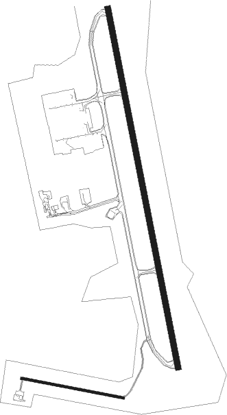
Runway info
Runway 17 / 35  | ||
| length | 2797m (9177ft) | |
| bearing | 168° / 348° | |
| width | 45m (148ft) | |
| surface | asphalt | |
| blast zone | 30m (98ft) / 30m (98ft) | |
| Runway 11 / 29 | ||
| length | 795m (2608ft) | |
| bearing | 99° / 279° | |
| width | 18m (59ft) | |
| surface | asphalt | |
Nearby beacons
| code | identifier | dist | bearing | frequency |
|---|---|---|---|---|
| SUP | STURUP (MALMO) VOR/DME | 1.2 | 118° | 113 |
| KAS | KASTRUP (COPENHAGEN) VOR/DME | 25.2 | 273° | 112.50 |
| KD | KRISTIANSTAD NDB | 31.2 | 66° | 375 |
| LJU | LJUNGBYHED VOR/DME | 32.5 | 344° | 113.40 |
| OEM | KRISTIANSTAD NDB | 36.6 | 59° | 363 |
| SVD | DME | 45.6 | 309° | 116.20 |
| AH | ANGELHOLM NDB | 45.7 | 328° | 417 |
| CDA | CODAN VOR/DME | 46.7 | 241° | 114.90 |
| LB | ANGELHOLM NDB | 51.8 | 324° | 370 |
Departure and arrival routes
| Transition altitude | 5000ft |
| SID end points | distance | outbound heading | |
|---|---|---|---|
| RW17 | |||
| NEXI1K | 49mi | 26° | |
| EKRA1K | 25mi | 69° | |
| TELM1K | 39mi | 123° | |
| SALO1K | 38mi | 177° | |
| DISG1K | 32mi | 237° | |
| ERNO1G, ERNO1K | 46mi | 309° | |
| BABS1K, BABS1G | 24mi | 338° | |
| RW35 | |||
| NEXI1L | 49mi | 26° | |
| EKRA1L | 25mi | 69° | |
| TELM1L | 39mi | 123° | |
| SALO1H, SALO1L | 38mi | 177° | |
| DISG1L, DISG1H | 32mi | 237° | |
| ERNO1L | 46mi | 309° | |
| BABS1L | 24mi | 338° | |
| STAR starting points | distance | inbound heading | |
|---|---|---|---|
| RW17 | |||
| DETU2S | 33.8 | 34° | |
| ERNO1S | 45.5 | 129° | |
| RASM1S | 74.2 | 201° | |
| EKRA1S | 24.7 | 249° | |
| ROE1S | 56.1 | 289° | |
| BAKL1S | 38.5 | 342° | |
| RW35 | |||
| DETU1T | 33.8 | 34° | |
| ERNO1T | 23.5 | 158° | |
| RASM1T | 62.0 | 192° | |
| EKRA1T | 24.7 | 249° | |
| ROE1T | 56.1 | 289° | |
| BAKL1T | 38.5 | 342° | |
Instrument approach procedures
| runway | airway (heading) | route (dist, bearing) |
|---|---|---|
| RW17-Y | XETRI (221°) | XETRI 5000ft MS520 (11mi, 228°) |
| RNAV | MS520 MS521 (3mi, 228°) 1800ft MS522 (2mi, 202°) ESMS (3mi, 192°) 266ft ESMS (turn) 2500ft (3400mi, 194°) | |
| RW35-Y | SITMU (230°) | SITMU 5000ft MS530 (13mi, 195°) |
| RNAV | MS530 MS550 (4mi, 179°) 4000ft MS551 (6mi, 268°) ESMS (4mi, 333°) 288ft ESMS (turn) 2500ft (3400mi, 194°) |
Holding patterns
| STAR name | hold at | type | turn | heading* | altitude | leg | speed limit |
|---|---|---|---|---|---|---|---|
| BAKL1S | TIDVU | VHF | right | 113 (293)° | > 5000ft | 1.5min timed | 230 |
| ERNO1S | NORVI | VHF | left | 348 (168)° | > 3000ft | 1.0min timed | 230 |
| RASM1S | NORVI | VHF | left | 348 (168)° | > 3000ft | 1.0min timed | 230 |
| *) magnetic outbound (inbound) holding course | |||||||
Disclaimer
The information on this website is not for real aviation. Use this data with the X-Plane flight simulator only! Data taken with kind consent from X-Plane 12 source code and data files. Content is subject to change without notice.