Grahamstown
Airport details
| Country | South Africa |
| State | Eastern Cape |
| Region | FA |
| Airspace | Cape Town Ctr |
| Municipality | Makana Local Municipality |
| Elevation | 2133ft (650m) |
| Timezone | GMT +2 |
| Coordinates | -33.28333, 26.50000 |
| Magnetic var | |
| Type | land |
| Available since | X-Plane v10.40 |
| ICAO code | FAGT |
| IATA code | n/a |
| FAA code | n/a |
Communication
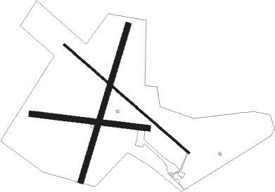
Runway info
Runway 16 / 34  | ||
| length | 1205m (3953ft) | |
| bearing | 130° / 310° | |
| width | 15m (49ft) | |
| surface | asphalt | |
| blast zone | 129m (423ft) / 155m (509ft) | |
| Runway 04 / 22 | ||
| length | 1189m (3901ft) | |
| bearing | 25° / 205° | |
| width | 40m (131ft) | |
| surface | grass | |
| blast zone | 0m (0ft) / 29m (95ft) | |
| Runway 12 / 30 | ||
| length | 854m (2802ft) | |
| bearing | 100° / 280° | |
| width | 40m (131ft) | |
| surface | grass | |
| blast zone | 47m (154ft) / 86m (282ft) | |
Nearby beacons
| code | identifier | dist | bearing | frequency |
|---|---|---|---|---|
| PEV | PORT ELIZABETH VOR/DME | 61.7 | 232° | 112.90 |
Disclaimer
The information on this website is not for real aviation. Use this data with the X-Plane flight simulator only! Data taken with kind consent from X-Plane 12 source code and data files. Content is subject to change without notice.