Pretoria - Swartkop
Airport details
| Country | South Africa |
| State | Gauteng |
| Region | FA |
| Airspace | Johannesburg Ctr |
| Municipality | Pretoria |
| Elevation | 4778ft (1456m) |
| Timezone | GMT +2 |
| Coordinates | -25.80930, 28.16362 |
| Magnetic var | |
| Type | land |
| Available since | X-Plane v10.40 |
| ICAO code | FASK |
| IATA code | n/a |
| FAA code | n/a |
Communication
| Swartkop Ground Control | 121.750 |
| Swartkop Tower | 123.200 |
| Swartkop Tower | 124.100 |
| Swartkop WATERKLOOF Approach | 124.500 |
| Swartkop WATERKLOOF Approach | 134.400 |
Nearby Points of Interest:
Weskoppies Psychiatric Hospital
-Palace of Justice (South Africa)
-Ou Raadsaal
-Van Wouw Museum
-Old Merensky Library
-Union Buildings
-Pretoria National Botanical Garden
-Gondolin Cave
-Swartkrans
-Gladysvale Cave
-Plovers Lake
-Drimolen
-Johannesburg City Library
-Chancellor House
-Coopers Cave
-Witwatersrand Gold Rush
-Paardekraal Monument
-James Mpanza House
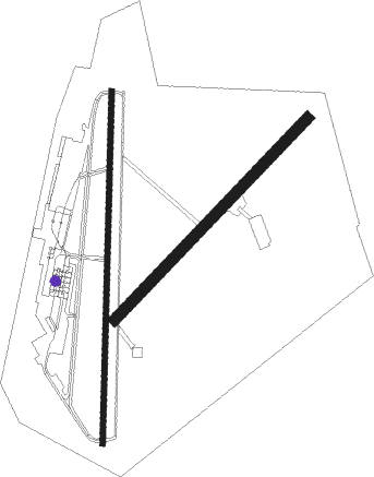
Runway info
Runway 02 / 20  | ||
| length | 1994m (6542ft) | |
| bearing | 7° / 187° | |
| width | 30m (98ft) | |
| surface | asphalt | |
| Runway 06 / 24 | ||
| length | 1580m (5184ft) | |
| bearing | 51° / 231° | |
| width | 61m (200ft) | |
| surface | dirt | |
| displ threshold | 91m (299ft) / 91m (299ft) | |
Nearby beacons
| code | identifier | dist | bearing | frequency |
|---|---|---|---|---|
| WKV | WATERKLOOF VOR/DME | 3.3 | 113° | 116.90 |
| DPV | WONDERBOOM VOR/DME | 9.7 | 20° | 112.20 |
| WR | WONDERBOOM (PRETORIA) NDB | 10.2 | 27° | 230 |
| GC | GRAND CENTRAL NDB | 11 | 187° | 372 |
| WB | WONDERBOOM (PRETORIA) NDB | 11.7 | 42° | 257 |
| LIV | LANSERIA VOR/DME | 15.9 | 241° | 117.40 |
| JSV | JOHANNESBURG VOR/DME | 21.2 | 169° | 115.20 |
| LA | LANSERIA NDB | 21.2 | 238° | 270 |
| MEV | BRONKHORSTSPRUIT VOR/DME | 21.5 | 87° | 114.30 |
| CZV | ZONDERWATER VOR/DME | 22.1 | 73° | 114.30 |
| RAV | RAND (JOHANNESBURG) VOR/DME | 26.1 | 181° | 117.70 |
| RD | RAND (JOHANNESBURG) NDB | 30.5 | 188° | 307 |
| RA | RAND NDB | 37.3 | 171° | 337 |
| VV | VEREENIGING NDB | 46.8 | 195° | 460 |
| RG | RUSTENBURG NDB | 48.5 | 280° | 452 |
| GAV | GRASMERE VOR | 49.8 | 215° | 115.50 |
| HGV | HEIDELBERG VOR | 53.6 | 172° | 116.70 |
| STV | STANDERTON VOR | 65.4 | 142° | 116 |
Disclaimer
The information on this website is not for real aviation. Use this data with the X-Plane flight simulator only! Data taken with kind consent from X-Plane 12 source code and data files. Content is subject to change without notice.