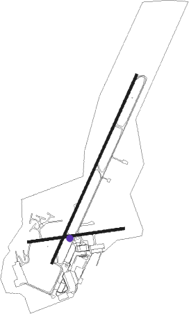
Maputo - Maputo Intl
Airport details
| Country | Mozambique |
| State | Maputo (city) |
| Region | FQ |
| Airspace | Beira Ctr |
| Municipality | Maputo |
| Elevation | 145ft (44m) |
| Timezone | GMT +2 |
| Coordinates | -25.92602, 32.56372 |
| Magnetic var | |
| Type | land |
| Available since | X-Plane v10.40 |
| ICAO code | FQMA |
| IATA code | MPM |
| FAA code | n/a |
Communication
| Maputo Intl Maputo Ground Control | 121.700 |
| Maputo Intl Maputo Ground Control | 121.900 |
| Maputo Intl Maputo Tower | 118.100 |
| Maputo Intl Maputo Approach | 121.300 |
Approach frequencies
| ILS-cat-II | RW23 | 110.3 | 18.00mi |
| 3° GS | RW23 | 110.3 | 18.00mi |
Nearby beacons
| code | identifier | dist | bearing | frequency |
|---|---|---|---|---|
| VMA | MAPUTO VOR/DME | 4 | 35° | 112.70 |
| VSK | SIKHUPHE VOR/DME | 53.1 | 242° | 117.10 |
Departure and arrival routes
| Transition altitude | 3000ft |
| SID end points | distance | outbound heading | |
|---|---|---|---|
| RW05 | |||
| UVAP1A | 86mi | 35° | |
| UVGN1B | 86mi | 54° | |
| UVER1A | 86mi | 66° | |
| UMTI1B | 56mi | 188° | |
| TONK1C | 27mi | 247° | |
| ORNA1C | 32mi | 271° | |
| UVDS1B | 85mi | 350° | |
| RW23 | |||
| UVDS1A | 86mi | 8° | |
| UVGN1A | 86mi | 35° | |
| UVTO1A | 86mi | 66° | |
| UMTI1A | 56mi | 188° | |
| TONK1A | 27mi | 247° | |
| ORNA1A | 32mi | 271° | |
| STAR starting points | distance | inbound heading | |
|---|---|---|---|
| RW05 | |||
| EPRE1A | 56.4 | 8° | |
| TONK1A | 27.4 | 67° | |
| ATUS1A | 85.3 | 170° | |
| EGPO1A | 85.9 | 188° | |
| AXIV1A | 85.1 | 201° | |
| ANTE1A | 86.3 | 210° | |
| IMTA1A | 86.3 | 215° | |
| APLA1A | 85.9 | 234° | |
| USUM1A | 85.5 | 246° | |
| NIKA1A | 84.8 | 257° | |
| RW23 | |||
| EPRE1B | 56.4 | 8° | |
| TONK1B | 27.4 | 67° | |
| ORNA1B | 32.2 | 91° | |
| ATUS1B | 85.3 | 170° | |
| EGPO1B | 85.9 | 188° | |
| AXIV1B | 85.1 | 201° | |
| ANTE1B | 86.3 | 210° | |
| IMTA1B | 86.3 | 215° | |
| APLA1B | 85.9 | 234° | |
| USUM1B | 85.5 | 246° | |
| NIKA1B | 84.8 | 257° | |
Instrument approach procedures
| runway | airway (heading) | route (dist, bearing) |
|---|---|---|
| RW05 | XAGRI (359°) | XAGRI 3300ft XOTOT (6mi, 297°) 1900ft |
| RW05 | XOTID (31°) | XOTID 3300ft XOTOT (6mi, 32°) 1900ft |
| RNAV | XOTOT 1900ft XOTIX (6mi, 31°) 1900ft FQMA (5mi, 28°) 170ft XAGVA (19mi, 32°) 3000ft | |
| RW23 | XAGVA (212°) | XAGVA 3400ft XAGOR (6mi, 211°) 1900ft |
| RW23 | XAKAL (186°) | XAKAL 3400ft XAGOR (6mi, 117°) 1900ft |
| RW23 | XAKAS (237°) | XAKAS 3400ft XAGOR (6mi, 297°) 1900ft |
| RNAV | XAGOR 1900ft XAGOT (6mi, 211°) 1900ft FQMA (7mi, 214°) 197ft XOTID (17mi, 211°) 3000ft |
Disclaimer
The information on this website is not for real aviation. Use this data with the X-Plane flight simulator only! Data taken with kind consent from X-Plane 12 source code and data files. Content is subject to change without notice.

