Kampala - Entebbe Intl
Airport details
| Country | Uganda |
| State | Wakiso |
| Region | HU |
| Airspace | Entebbe Ctr |
| Municipality | Entebbe City |
| Elevation | 3782ft (1153m) |
| Timezone | GMT +3 |
| Coordinates | 0.04081, 32.44054 |
| Magnetic var | |
| Type | land |
| Available since | X-Plane v10.40 |
| ICAO code | HUEN |
| IATA code | EBB |
| FAA code | n/a |
Communication
| Entebbe Intl Atis | 120.200 |
| Entebbe Intl Tower | 118.100 |
| Entebbe Intl Approach 1 | 126.600 |
| Entebbe Intl Approach 2 | 119.100 |
Approach frequencies
| ILS-cat-I | RW17 | 110.7 | 18.00mi |
| 3° GS | RW17 | 110.7 | 18.00mi |
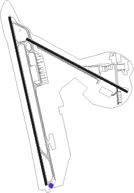
Runway info
Runway 12 / 30  | ||
| length | 2425m (7956ft) | |
| bearing | 122° / 302° | |
| width | 45m (148ft) | |
| surface | asphalt | |
| Runway 17 / 35 | ||
| length | 3678m (12067ft) | |
| bearing | 172° / 352° | |
| width | 45m (148ft) | |
| surface | asphalt | |
Nearby beacons
| code | identifier | dist | bearing | frequency |
|---|---|---|---|---|
| NN | ENTEBBE VOR/DME | 0.7 | 348° | 117.50 |
| EM | ENTEBBE NDB | 5.9 | 351° | 355 |
| PB | PORTBELL NDB | 20 | 40° | 270 |
Departure and arrival routes
| Transition altitude | 7000ft |
| Transition level | 8000ft |
| SID end points | distance | outbound heading | |
|---|---|---|---|
| RW17 | |||
| IMVI1B | 66mi | 45° | |
| PASA1B | 64mi | 107° | |
| OKSU1B | 65mi | 126° | |
| BETA1B | 64mi | 136° | |
| APNA1B | 63mi | 174° | |
| MAND1B | 64mi | 229° | |
| SEZI1B | 65mi | 305° | |
| UVBA1B | 66mi | 349° | |
| RW35 | |||
| IMVI1D | 66mi | 45° | |
| PASA1D | 64mi | 107° | |
| OKSU1D | 65mi | 126° | |
| BETA1D | 64mi | 136° | |
| APNA1D | 63mi | 174° | |
| MAND1D | 64mi | 229° | |
| SEZI1D | 65mi | 305° | |
| UVBA1D | 66mi | 349° | |
| STAR starting points | distance | inbound heading | |
|---|---|---|---|
| RW17 | |||
| MAND1A | 64.4 | 49° | |
| SEZI1A | 65.3 | 125° | |
| UVBA1A | 66.1 | 169° | |
| IMVI1A | 65.5 | 225° | |
| IMPO1A | 64.8 | 271° | |
| OKSU1A | 64.5 | 306° | |
| BETA1A | 63.7 | 316° | |
| APNA1A | 63.0 | 354° | |
| RW35 | |||
| MAND1C | 64.4 | 49° | |
| SEZI1C | 65.3 | 125° | |
| UVBA1C | 66.1 | 169° | |
| IMVI1C | 65.5 | 225° | |
| IMPO1C | 64.8 | 271° | |
| OKSU1C | 64.5 | 306° | |
| BETA1C | 63.7 | 316° | |
| APNA1C | 63.0 | 354° | |
Instrument approach procedures
| runway | airway (heading) | route (dist, bearing) |
|---|---|---|
| RW17 | AVEXO (172°) | AVEXO AVULI (13mi, 172°) 7700ft |
| RW17 | ETKUL (224°) | ETKUL AVULI (17mi, 262°) 7700ft |
| RW17 | UVDEK (119°) | UVDEK AVULI (17mi, 82°) 7700ft |
| RNAV | AVULI 7700ft IBSET (6mi, 172°) 5800ft HUEN (7mi, 171°) 3830ft AVEBI (9mi, 173°) ANTET (17mi, 95°) ANTET (turn) | |
| RW35 | AVAMA (352°) | AVAMA IBKUD (13mi, 352°) 7700ft |
| RW35 | EPMIS (300°) | EPMIS IBKUD (17mi, 262°) 7700ft |
| RW35 | GESEM (45°) | GESEM IBKUD (17mi, 82°) 7700ft |
| RNAV | IBKUD 7700ft UTSAS (6mi, 352°) 5800ft HUEN (7mi, 353°) 3795ft EVEKO (13mi, 352°) EGNEX (17mi, 262°) EGNEX (turn) |
Disclaimer
The information on this website is not for real aviation. Use this data with the X-Plane flight simulator only! Data taken with kind consent from X-Plane 12 source code and data files. Content is subject to change without notice.