Auburn - Farington Field
Airport details
| Country | United States of America |
| State | Nebraska |
| Region | |
| Airspace | Minneapolis Ctr |
| Municipality | Nemaha County |
| Elevation | 923ft (281m) |
| Timezone | GMT -6 |
| Coordinates | 40.39056, -95.78941 |
| Magnetic var | |
| Type | land |
| Available since | X-Plane v10.40 |
| ICAO code | K01 |
| IATA code | n/a |
| FAA code | K01 |
Communication
Nearby Points of Interest:
Auburn United States Post Office
-Nemaha County Courthouse
-John W. Bennett House
-Brownville Bridge
-Camp Creek School, Otoe County District No. 54
-George F. Lee Octagon Houses
-Hamburg Public Library
-John Holman House
-U.S. Post Office
-Morton-James Public Library
-Grand Army of the Republic Memorial Hall
-Otoe County Courthouse
-St. John's Evangelical Lutheran Church
-Rankin Hall
-Johnson County Courthouse
-Tecumseh Opera House
-Chautauqua Pavilion
-Jason and Elizabeth Baylor Rector House
-Richardson County Courthouse
-Gehling's Theatre
-Alfred and Magdalena Schmid Farmstead
-Fremont County Courthouse
-Rad Jan Kollar cis 101 Z.C.B.J.
-Pawnee County Courthouse
-Rulo Bridge
Runway info
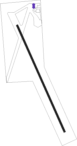
| Runway 16 / 34 | ||
| length | 1147m (3763ft) | |
| bearing | 155° / 335° | |
| width | 18m (60ft) | |
| surface | concrete | |
Nearby beacons
| code | identifier | dist | bearing | frequency |
|---|---|---|---|---|
| AFK | NEBRASKA CITY NDB | 13.3 | 342° | 347 |
| PWE | PAWNEE CITY VORTAC | 22.2 | 245° | 112.40 |
| PMV | PLATTSMOUTH NDB | 33.6 | 347° | 329 |
| RBA | DME | 36.5 | 146° | 108.20 |
| OFF | OFFUTT (OMAHA) TACAN | 43.9 | 351° | 111.70 |
| BIE | BEATRICE VOR | 44.5 | 265° | 110.60 |
| OVR | OMAHA VORTAC | 46.7 | 4° | 116.30 |
| STJ | SAINT JOSEPH (ST JOSEPH) VORTAC | 47.3 | 116° | 115.50 |
| LN | POTTS (LINCOLN) NDB | 49.2 | 290° | 385 |
| AZN | AMAZON (SAINT JOSEPH) NDB | 50.6 | 120° | 233 |
| LNK | LINCOLN VORTAC | 53.9 | 299° | 116.10 |
| ST | TARIO (ST JOSEPH) NDB | 59 | 129° | 260 |
| AHQ | WAHOO NDB | 62.8 | 316° | 400 |
Instrument approach procedures
| runway | airway (heading) | route (dist, bearing) |
|---|---|---|
| RW16 | OBAKE (189°) | OBAKE OLMEE (6mi, 255°) 3600ft |
| RW16 | OLMEE (155°) | OLMEE 3600ft |
| RW16 | SWART (126°) | SWART OLMEE (6mi, 75°) 3600ft |
| RNAV | OLMEE 3600ft ZUSUP (7mi, 155°) 3000ft STOTS (4mi, 155°) 1720ft K01 (2mi, 155°) 964ft (5670mi, 113°) 1180ft ORAKE (5666mi, 293°) 3600ft ORAKE (turn) 3600ft | |
| RW34 | ORAKE (335°) | ORAKE 3600ft |
| RW34 | PRAAM (309°) | PRAAM ORAKE (6mi, 255°) 3600ft |
| RW34 | WIGIT (5°) | WIGIT ORAKE (6mi, 75°) 3600ft |
| RNAV | ORAKE 3600ft ZUPIT (8mi, 335°) 3000ft FEPOP (3mi, 335°) 1960ft K01 (4mi, 335°) 948ft (5670mi, 113°) 1175ft OLMEE (5673mi, 293°) 3600ft OLMEE (turn) |
Disclaimer
The information on this website is not for real aviation. Use this data with the X-Plane flight simulator only! Data taken with kind consent from X-Plane 12 source code and data files. Content is subject to change without notice.