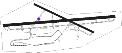
Pittsburgh - Allegheny Co
Airport details
| Country | United States of America |
| State | Pennsylvania |
| Region | K6 |
| Airspace | Cleveland Ctr |
| Municipality | West Mifflin |
| Elevation | 1250ft (381m) |
| Timezone | GMT -5 |
| Coordinates | 40.35319, -79.93023 |
| Magnetic var | |
| Type | land |
| Available since | X-Plane v10.30 |
| ICAO code | KAGC |
| IATA code | AGC |
| FAA code | AGC |
Communication
| ALLEGHENY CO ATIS | 120.550 |
| ALLEGHENY CO UNICOM | 122.950 |
| ALLEGHENY CO Ground Control | 121.700 |
| ALLEGHENY CO Tower | 239.000 |
| ALLEGHENY CO Tower | 121.100 |
| ALLEGHENY CO PITTSBURGH Approach | 119.350 |
| ALLEGHENY CO PITTSBURGH Approach | 285.570 |
| ALLEGHENY CO PITTSBURGH Approach | 337.400 |
| ALLEGHENY CO PITTSBURGH Departure | 119.350 |
| ALLEGHENY CO PITTSBURGH Departure | 285.570 |
| ALLEGHENY CO PITTSBURGH Departure | 337.400 |
Approach frequencies
| ILS-cat-I | RW28 | 109.1 | 18.00mi |
| ILS-cat-I | RW10 | 109.1 | 18.00mi |
| 3° GS | RW28 | 109.1 | 18.00mi |
| 3° GS | RW10 | 109.1 | 18.00mi |
Nearby Points of Interest:
Jerome Street Bridge
-McKeesport National Bank
-Homestead Historic District
-Homestead station
-Carnegie Free Library
-Homestead Grays Bridge
-Bost Building
-Experimental Mine, U.S. Bureau of Mines
-John Woods House
-Linden Grove
-Carnegie Free Library of Braddock
-Longfellow School
-Pittsburgh Mercantile Company Building
-Samuel F.B. Morse School
-Oakland Public School
-Bowman Homestead
-George Westinghouse Bridge
-Birmingham Public School
-Panther Hollow Bridge
-Gardner-Bailey House
-South Side Market Building
-Bedford School
-Wightman School
-Boggs Avenue Elementary School
-Carnegie Library of Pittsburgh
Nearby beacons
| code | identifier | dist | bearing | frequency |
|---|---|---|---|---|
| AGC | ALLEGHENY (PITTSBURGH) VOR/DME | 6.7 | 236° | 110 |
| MMJ | (PITTSBURGH) DME | 14.5 | 297° | 112 |
| VV | CAMOR (CONNELLSVILLE) NDB | 29.5 | 158° | 299 |
| HLG | WHEELING VOR/DME | 29.7 | 262° | 112.20 |
| EWC | ELLWOOD CITY VOR/DME | 31.1 | 329° | 115.80 |
| IHD | INDIAN HEAD VORTAC | 34.7 | 124° | 108.20 |
| AIR | BELLAIRE VOR/DME | 45.4 | 249° | 117.10 |
| UCP | CASTLE (NEW CASTLE) NDB | 45.9 | 324° | 272 |
| MGW | MORGANTOWN VOR/DME | 47.9 | 175° | 111.60 |
| CIP | DME | 52.2 | 31° | 112.90 |
| GRV | DME | 59.1 | 129° | 112.30 |
| YN | FETCH (YOUNGSTOWN/WARREN) NDB | 59.2 | 322° | 338 |
| YNG | YOUNGSTOWN VORTAC | 67.7 | 323° | 109 |
Departure and arrival routes
| Transition altitude | 18000ft |
| Transition level | 18000ft |
| SID end points | distance | outbound heading | |
|---|---|---|---|
| RW10 | |||
| AGC9 | 22mi | 302° | |
| RW13 | |||
| AGC9 | 22mi | 302° | |
| RW28 | |||
| AGC9 | 22mi | 302° | |
| RW31 | |||
| AGC9 | 22mi | 302° | |
Instrument approach procedures
| runway | airway (heading) | route (dist, bearing) |
|---|---|---|
| RW10 | WISKE (73°) | WISKE HYETO (26mi, 65°) 3000ft |
| RNAV | HYETO 3000ft SHANS (6mi, 90°) 3000ft WOLES (3mi, 90°) 2080ft KAGC (3mi, 91°) 1296ft (4945mi, 117°) 1451ft LENLE (4940mi, 297°) NESTO (10mi, 151°) 3100ft NESTO (turn) | |
| RW28 | HOMEE (253°) | HOMEE KATKE (12mi, 229°) 4000ft MILKE (4mi, 270°) 3000ft |
| RW28 | MILWO (275°) | MILWO KATKE (9mi, 285°) 4000ft MILKE (4mi, 270°) 3000ft |
| RNAV | MILKE 3000ft LENLE (6mi, 270°) 3000ft KAGC (6mi, 269°) 1301ft (4945mi, 117°) 1563ft MESIE (4950mi, 297°) AGC (5mi, 191°) 3000ft AGC (turn) |
Disclaimer
The information on this website is not for real aviation. Use this data with the X-Plane flight simulator only! Data taken with kind consent from X-Plane 12 source code and data files. Content is subject to change without notice.

