Akron - Akron Fulton Intl
Airport details
| Country | United States of America |
| State | Ohio |
| Region | K5 |
| Airspace | Cleveland Ctr |
| Municipality | Akron |
| Elevation | 1064ft (324m) |
| Timezone | GMT -5 |
| Coordinates | 41.03750, -81.46692 |
| Magnetic var | |
| Type | land |
| Available since | X-Plane v10.30 |
| ICAO code | KAKR |
| IATA code | AKC |
| FAA code | AKR |
Communication
| Akron Fulton Intl ASOS | 126.825 |
| Akron Fulton Intl CTAF/UNICOM | 123.075 |
| Akron Fulton Intl Approach/Departure | 118.600 |
Approach frequencies
| LOC | RW25 | 110.9 | 18.00mi |
Nearby Points of Interest:
Akron Fulton International Airport Administration Building
-Goodyear Airdock
-Goodyear Hall-Ohio Savings and Trust Company
-St. Paul's Sunday School and Parish House
-Summit County Courthouse
-Akron Post Office and Federal Building
-Eagles Temple
-The Gothic Building
-Huntington Tower
-Akron Public Library
-Grace Reformed Church
-Akron YMCA Building
-Akron Rural Cemetery Buildings
-Cascade Locks Historic District
-Francis D. Alling House
-Akron Jewish Center
-Dr. Robert Smith House
-O. C. Barber Colt Barn
-Frank Mason Raymond House
-First Congregational Church of Cuyahoga Falls
-O. C. Barber Creamery
-O. C. Barber Barn No. 1
-O. C. Barber Piggery
-Aaron Ferrey House
-Anna-Dean Farm
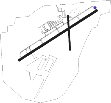
Runway info
Runway 7 / 25  | ||
| length | 1928m (6325ft) | |
| bearing | 68° / 248° | |
| width | 46m (151ft) | |
| surface | asphalt | |
| displ threshold | 230m (755ft) / 79m (259ft) | |
| Runway 1 / 19 | ||
| length | 713m (2339ft) | |
| bearing | 1° / 181° | |
| width | 30m (98ft) | |
| surface | asphalt | |
| displ threshold | 0m (0ft) / 58m (190ft) | |
Nearby beacons
| code | identifier | dist | bearing | frequency |
|---|---|---|---|---|
| AK | AKRON NDB | 4 | 68° | 362 |
| ACO | AKRON VOR/DME | 12.7 | 75° | 114.40 |
| BSV | BRIGGS VOR/DME | 17.8 | 173° | 112.40 |
| CXR | CHARDON VOR/DME | 31.8 | 32° | 112.70 |
| BF | TABEY (CLEVELAND) NDB | 32.2 | 349° | 248 |
| DJB | DRYER VOR/DME | 36.8 | 295° | 113.60 |
| LQL | LAKELAND (WILLOUGHBY) NDB | 38.9 | 8° | 263 |
| YNG | YOUNGSTOWN VORTAC | 39.9 | 70° | 109 |
| YN | FETCH (YOUNGSTOWN/WARREN) NDB | 40.5 | 79° | 338 |
| MF | MANNS (MANSFIELD) NDB | 47.2 | 254° | 372 |
| CTW | DME | 48.5 | 181° | 111.80 |
| CFX | CADIZ NDB | 52.3 | 150° | 239 |
| JFN | JEFFERSON VOR/DME | 54.1 | 45° | 115.20 |
| HLG | WHEELING VOR/DME | 62 | 131° | 112.20 |
Departure and arrival routes
| Transition altitude | 18000ft |
| Transition level | 18000ft |
| STAR starting points | distance | inbound heading | |
|---|---|---|---|
| ALL | |||
| HUUVR1 | 24.4 | 37° | |
| BRWNZ4 | 59.3 | 138° | |
| ZZIPS1 | 12.0 | 271° | |
Instrument approach procedures
| runway | airway (heading) | route (dist, bearing) |
|---|---|---|
| RW25 | OGVOE (248°) | OGVOE 6000ft OGVOE (turn) 3100ft |
| RNAV | OGVOE 3100ft IRAYO (6mi, 248°) 2300ft ESPUQ (2mi, 248°) 1600ft KAKR (2mi, 248°) 1109ft (5019mi, 117°) 1468ft AWNEV (5029mi, 297°) 3100ft AWNEV (turn) |
Holding patterns
| STAR name | hold at | type | turn | heading* | altitude | leg | speed limit |
|---|---|---|---|---|---|---|---|
| BRWNZ4 | BRWNZ | VHF | left | 293 (113)° | DME 10.0mi | ICAO rules | |
| BRWNZ4 | DETMR | VHF | left | 282 (102)° | DME 10.0mi | ICAO rules | |
| BRWNZ4 | FRYYE | VHF | left | 284 (104)° | DME 10.0mi | ICAO rules | |
| *) magnetic outbound (inbound) holding course | |||||||
Disclaimer
The information on this website is not for real aviation. Use this data with the X-Plane flight simulator only! Data taken with kind consent from X-Plane 12 source code and data files. Content is subject to change without notice.