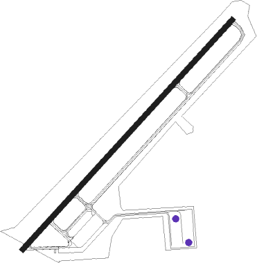
Angola - Tri State Steuben Co
Airport details
| Country | United States of America |
| State | Indiana |
| Region | K5 |
| Airspace | Chicago Ctr |
| Municipality | Steuben County |
| Elevation | 995ft (303m) |
| Timezone | GMT -5 |
| Coordinates | 41.63970, -85.08350 |
| Magnetic var | |
| Type | land |
| Available since | X-Plane v10.40 |
| ICAO code | KANQ |
| IATA code | ANQ |
| FAA code | ANQ |
Communication
| TRI STATE STEUBEN CO CTAF/UNICOM | 123.075 |
| TRI STATE STEUBEN CO FORT WAYNE Approach/Departure | 132.150 |
| TRI STATE STEUBEN CO FORT WAYNE Approach/Departure | 127.200 |
Nearby Points of Interest:
Cornish Griffin Round Barn
-Angola Commercial Historic District
-Steuben County Courthouse
-CCC Shelter
-Pleasant Lake Depot
-John O'Ferrell Store
-Maria and Franklin Wiltrout Polygonal Barn
-Waterloo Community Mausoleum
-William L. Lords House
-Iddings-Gilbert-Leader-Anderson Block
-Kendallville Downtown Historic District
-Ezra E. and Florence (Holmes) Beardsley House
-LaGrange County Courthouse
-Joseph Bowman Farmhouse
-Downtown Butler Historic District
-Samuel P. Williams House
-John Badlam Howe Mansion
-Rakestraw House
-Auburn Community Mausoleum
-Downtown Auburn Historic District
-Brethren in Christ Church
-Breechbill-Davidson House
-William Fountain House
-Gump House
-Star Milling and Electric Company Historic District
Runway info
| Runway 5 / 23 | ||
| length | 1384m (4541ft) | |
| bearing | 55° / 235° | |
| width | 23m (75ft) | |
| surface | asphalt | |
| displ threshold | 163m (535ft) / 0m (0ft) | |
| blast zone | 84m (276ft) / 0m (0ft) | |
Nearby beacons
| code | identifier | dist | bearing | frequency |
|---|---|---|---|---|
| IRS | STURGIS NDB | 18.8 | 296° | 382 |
| GW | SHENK (AUBURN) NDB | 20.8 | 157° | 227 |
| LFD | LITCHFIELD VOR/DME | 29.1 | 37° | 111.20 |
| OLK | WEBSTER LAKE VOR | 30 | 226° | 110.40 |
| AZ | AUSTN (KALAMAZOO) NDB | 35.6 | 318° | 371 |
| FWA | FORT WAYNE VORTAC | 39.9 | 189° | 117.80 |
| AZO | KALAMAZOO VOR/DME | 41.5 | 322° | 109 |
| GSH | GOSHEN VORTAC | 42.9 | 263° | 113.70 |
| BT | BATOL (BATTLE CREEK) NDB | 43.6 | 352° | 272 |
| JXN | DME | 46.5 | 45° | 115.45 |
Instrument approach procedures
| runway | airway (heading) | route (dist, bearing) |
|---|---|---|
| RW05 | BRYTO (114°) | BRYTO HOBAD (10mi, 190°) 3000ft FELAX (5mi, 129°) 3000ft |
| RW05 | FELAX (55°) | FELAX 3000ft |
| RW05 | ILTON (325°) | ILTON WADLI (10mi, 257°) 3000ft FELAX (5mi, 309°) 3000ft |
| RW05 | OLK (46°) | OLK FELAX (19mi, 41°) 3000ft |
| RNAV | FELAX 3000ft AVROY (6mi, 55°) 2700ft KANQ (5mi, 55°) 1023ft (5185mi, 116°) 1395ft WILAT (5177mi, 296°) 3000ft WILAT (turn) | |
| RW23 | BRYTO (114°) | BRYTO GILKE (16mi, 75°) 3000ft WILAT (5mi, 129°) 3000ft |
| RW23 | ILTON (325°) | ILTON ESILE (15mi, 38°) 3000ft WILAT (5mi, 309°) 3000ft |
| RW23 | LFD (217°) | LFD WILAT (19mi, 204°) 3000ft |
| RW23 | WILAT (235°) | WILAT 10000ft WILAT (turn) 3000ft |
| RNAV | WILAT 3000ft JALIR (6mi, 235°) 2700ft KANQ (6mi, 235°) 1045ft (5185mi, 116°) 1395ft FELAX (5192mi, 296°) 3000ft FELAX (turn) |
Disclaimer
The information on this website is not for real aviation. Use this data with the X-Plane flight simulator only! Data taken with kind consent from X-Plane 12 source code and data files. Content is subject to change without notice.
