Hartford - Bradley Intl
Airport details
| Country | United States of America |
| State | Connecticut |
| Region | K6 |
| Airspace | Boston Ctr |
| Municipality | Windsor Locks |
| Elevation | 169ft (52m) |
| Timezone | GMT -5 |
| Coordinates | 41.93914, -72.68337 |
| Magnetic var | |
| Type | land |
| Available since | X-Plane v10.30 |
| ICAO code | KBDL |
| IATA code | BDL |
| FAA code | BDL |
Communication
| Bradley Intl ATIS | 118.150 |
| Bradley Intl UNICOM | 122.950 |
| Bradley Intl Clearance DEL | 121.750 |
| Bradley Intl Ground Control | 121.900 |
| Bradley Intl Tower | 125.650 |
| Bradley Intl Tower | 120.300 |
| Bradley Intl Approach | 125.350 |
| Bradley Intl Approach | 123.950 |
| Bradley Intl Approach | 127.225 |
| Bradley Intl Approach | 127.800 |
| Bradley Intl Departure | 127.800 |
| Bradley Intl Departure | 123.950 |
| Bradley Intl Departure | 125.350 |
Approach frequencies
| ILS-cat-III | RW06 | 111.1 | 18.00mi |
| ILS-cat-II | RW24 | 111.1 | 18.00mi |
| ILS-cat-I | RW33 | 108.55 | 18.00mi |
| 3° GS | RW06 | 111.1 | 18.00mi |
| 3° GS | RW33 | 108.55 | 18.00mi |
| 3° GS | RW24 | 111.1 | 18.00mi |
Nearby Points of Interest:
Benomi Case House
-Lewis-Zukowski House
-Noden-Reed Museum
-Alexander King House
-Memorial Hall
-Bridge No. 455
-Hatheway House
-Ezekiel Phelps House
-Eli Phelps House
-Viets' Tavern
-Whitfield Cowles House
-house at 130 Hayden Station Road
-Bissell Tavern-Bissell's Stage House
-King's Field House
-Enfield Falls Canal
-Oliver Ellsworth Homestead
-House at 736 Palisado Avenue
-Enfield Town Meetinghouse
-First Church Parsonage
-McLean Game Refuge
-John Fuller House
-Sophia Sweetland House
-Taylor Chapman House
-Henry Magill House
-Patrick Murphy House
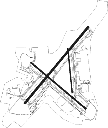
Runway info
Runway 1 / 19  | ||
| length | 1302m (4272ft) | |
| bearing | 359° / 179° | |
| width | 30m (100ft) | |
| surface | asphalt | |
| displ threshold | 146m (479ft) / 0m (0ft) | |
| blast zone | 8m (26ft) / 0m (0ft) | |
| Runway 6 / 24 | ||
| length | 2898m (9508ft) | |
| bearing | 53° / 233° | |
| width | 61m (200ft) | |
| surface | asphalt | |
| blast zone | 74m (243ft) / 255m (837ft) | |
| Runway 15 / 33 | ||
| length | 2086m (6844ft) | |
| bearing | 126° / 306° | |
| width | 46m (150ft) | |
| surface | asphalt | |
| blast zone | 255m (837ft) / 29m (95ft) | |
Nearby beacons
| code | identifier | dist | bearing | frequency |
|---|---|---|---|---|
| BAF | BARNES (WESTFIELD/SPRINGF VORTAC | 13.4 | 352° | 113 |
| CEF | WESTOVER(SPRINGFIELD/CHIC TACAN | 17 | 31° | 114 |
| HFD | HARTFORD VOR/DME | 18.9 | 155° | 114.90 |
| CTR | CHESTER VOR/DME | 24.2 | 323° | 115.10 |
| MAD | MADISON VOR/DME | 37.5 | 181° | 110.40 |
| PUT | PUTNAM VOR/DME | 37.5 | 89° | 117.40 |
| ORW | NORWICH VOR/DME | 38.3 | 119° | 110 |
| HVN | HAVEN DME | 41.6 | 197° | 109.80 |
| PWL | PAWLING (POUGHKEEPSIE) VOR/DME | 42.2 | 260° | 114.30 |
| GDM | GARDNER VOR/DME | 45.8 | 46° | 110.60 |
| GON | GROTON VOR/DME | 46.2 | 134° | 110.85 |
| BDR | BRIDGEPORT VOR/DME | 50.7 | 210° | 108.80 |
| EEN | DME | 54.2 | 25° | 109.40 |
| CMK | CARMEL VOR/DME | 56.5 | 234° | 116.60 |
Departure and arrival routes
| Transition altitude | 18000ft |
| Transition level | 18000ft |
| SID end points | distance | outbound heading | |
|---|---|---|---|
| RW06 | |||
| BRADL6 | 13mi | 171° | |
| CSTL9 | 61mi | 187° | |
| RW15 | |||
| BRADL6 | 13mi | 171° | |
| CSTL9 | 61mi | 187° | |
| RW24 | |||
| BRADL6 | 13mi | 171° | |
| CSTL9 | 61mi | 187° | |
| RW33 | |||
| BRADL6 | 13mi | 171° | |
| CSTL9 | 61mi | 187° | |
| STAR starting points | distance | inbound heading | |
|---|---|---|---|
| ALL | |||
| STELA1 | 47.5 | 126° | |
Instrument approach procedures
| runway | airway (heading) | route (dist, bearing) |
|---|---|---|
| RW06-Y | HFD (335°) | HFD PENNA (17mi, 297°) 3000ft PENNA (turn) 3000ft |
| RNAV | PENNA 3000ft JANID (3mi, 53°) 2400ft HUNEE (3mi, 53°) 1800ft JETIX (2mi, 53°) 1160ft KBDL (4mi, 54°) 227ft (4637mi, 120°) 373ft KIBBE (4630mi, 300°) 3000ft KIBBE (turn) | |
| RW06-Z | BRISS (55°) | BRISS 3000ft PENNA (9mi, 57°) 3000ft JANID (3mi, 53°) 2400ft HUNEE (3mi, 53°) 1800ft |
| RW06-Z | DILLN (102°) | DILLN 5000ft YELOW (3mi, 219°) 4000ft CABAG (3mi, 172°) 3000ft HUNEE (4mi, 91°) 1800ft |
| RW06-Z | DWOLF (340°) | DWOLF 5000ft RABPO (3mi, 247°) 4000ft WHISL (4mi, 292°) 2400ft HUNEE (2mi, 27°) 1800ft |
| RW06-Z | ERICH (23°) | ERICH 5000ft WHISL (8mi, 357°) 2400ft HUNEE (2mi, 27°) 1800ft |
| RW06-Z | MIICH (93°) | MIICH 5000ft CABAG (6mi, 129°) 3000ft HUNEE (4mi, 91°) 1800ft |
| RNAV | HUNEE 1800ft KBDL (6mi, 54°) 227ft KIBBE (14mi, 52°) 3000ft KIBBE (turn) | |
| RW15 | CTR (143°) | CTR DOCEB (14mi, 160°) 3500ft |
| RW15 | DOCEB (125°) | DOCEB 3500ft |
| RW15 | SASHA (113°) | SASHA DOCEB (13mi, 103°) 3500ft |
| RNAV | DOCEB 3500ft BREEN (5mi, 126°) 2500ft UHLAN (3mi, 126°) 1280ft KBDL (3mi, 123°) 229ft (4637mi, 120°) 478ft HADUX (4627mi, 300°) 3000ft HADUX (turn) 3000ft | |
| RW24-Y | KIBBE (232°) | KIBBE 3000ft |
| RNAV | KIBBE 3000ft MOTEL (7mi, 233°) 2100ft FARIL (5mi, 233°) 640ft KBDL (2mi, 229°) 216ft (4637mi, 120°) 370ft PENNA (4643mi, 300°) 3000ft PENNA (turn) | |
| RW24-Z | BRYCE (148°) | BRYCE 5000ft ELILE (4mi, 68°) 3800ft ONTEW (4mi, 108°) 2400ft PAGNE (2mi, 199°) 1600ft |
| RW24-Z | KAGZI (199°) | KAGZI 4000ft ONTEW (5mi, 160°) 2400ft PAGNE (2mi, 199°) 1600ft |
| RW24-Z | KIBBE (232°) | KIBBE 3000ft DENNO (5mi, 233°) 2600ft PAGNE (4mi, 233°) 1600ft |
| RW24-Z | NEEDY (287°) | NEEDY 5000ft HADGO (4mi, 16°) 3600ft PAGNE (5mi, 292°) 1600ft |
| RNAV | PAGNE 1600ft KBDL (5mi, 231°) 216ft PENNA (12mi, 233°) 3000ft PENNA (turn) | |
| RW33 | HADUX (307°) | HADUX 2500ft |
| RW33 | HFD (335°) | HFD HADUX (10mi, 16°) 2500ft |
| RW33 | ORW (299°) | ORW HADUX (27mi, 296°) 2500ft |
| RNAV | HADUX 2500ft HOMEY (6mi, 306°) 1800ft KBDL (6mi, 308°) 228ft (4637mi, 120°) 371ft DOCEB (4647mi, 300°) 3500ft DOCEB (turn) 3500ft |
Holding patterns
| STAR name | hold at | type | turn | heading* | altitude | leg | speed limit |
|---|---|---|---|---|---|---|---|
| DPK3 | BRISS | VHF | right | 161 (341)° | < 14000ft | 1.0min timed | ICAO rules |
| STELA1 | STELA | VHF | right | 327 (147)° | < 14000ft | 1.0min timed | ICAO rules |
| *) magnetic outbound (inbound) holding course | |||||||
Disclaimer
The information on this website is not for real aviation. Use this data with the X-Plane flight simulator only! Data taken with kind consent from X-Plane 12 source code and data files. Content is subject to change without notice.