Bismarck - Bismarck Municipal
Airport details
| Country | United States of America |
| State | North Dakota |
| Region | K3 |
| Airspace | Minneapolis Ctr |
| Municipality | Bismarck |
| Elevation | 1661ft (506m) |
| Timezone | GMT -6 |
| Coordinates | 46.77272, -100.74575 |
| Magnetic var | |
| Type | land |
| Available since | X-Plane v10.40 |
| ICAO code | KBIS |
| IATA code | BIS |
| FAA code | BIS |
Communication
| Bismarck Municipal ATIS | 119.350 |
| Bismarck Municipal CTAF | 118.300 |
| Bismarck Municipal UNICOM | 122.950 |
| Bismarck Municipal GROUND | 121.900 |
| Bismarck Municipal TOWER | 118.300 |
| Bismarck Municipal ApproachROACH | 126.300 |
| Bismarck Municipal DepartureARTURE | 126.300 |
Approach frequencies
| ILS-cat-I | RW31 | 110.3 | 18.00mi |
| ILS-cat-I | RW13 | 111.5 | 18.00mi |
| 3° GS | RW31 | 110.3 | 18.00mi |
| 3° GS | RW13 | 111.5 | 18.00mi |
Nearby Points of Interest:
Dr. Albert M. and Evelyn M. Brandt House
-Northern Pacific Railway Depot
-Bismarck Civic Auditorium
-E. G. Patterson Building
-Burleigh County Courthouse
-Bismarck Tribune Building
-United States Post Office and Courthouse
-Towne–Williams House
-Former North Dakota Executive Mansion
-Fred and Gladys Grady House
-Bismarck Cathedral Area Historic District
-Our Lady of the Annunciation Chapel at Annunciation Priory
-Liberty Memorial Bridge
-Wilton, North Dakota Soo Line depot
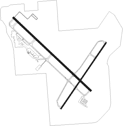
Runway info
Runway 13 / 31  | ||
| length | 2678m (8786ft) | |
| bearing | 127° / 307° | |
| width | 46m (150ft) | |
| surface | asphalt | |
| blast zone | 61m (200ft) / 61m (200ft) | |
| Runway 3 / 21 | ||
| length | 2010m (6594ft) | |
| bearing | 50° / 230° | |
| width | 30m (100ft) | |
| surface | asphalt | |
| blast zone | 61m (200ft) / 62m (203ft) | |
Nearby beacons
| code | identifier | dist | bearing | frequency |
|---|---|---|---|---|
| BIS | BISMARCK VOR/DME | 3.3 | 98° | 116.50 |
| HZE | HAZEN NDB | 46.5 | 302° | 414 |
Instrument approach procedures
| runway | airway (heading) | route (dist, bearing) |
|---|---|---|
| RW03 | BIS (278°) | BIS AXAXE (15mi, 240°) 4500ft AXAXE (turn) 4500ft |
| RW03 | CENTR (120°) | CENTR AXAXE (26mi, 151°) 4500ft AXAXE (turn) 4500ft |
| RW03 | OHROR (18°) | OHROR AXAXE (7mi, 315°) 4500ft |
| RW03 | SAILM (92°) | SAILM AXAXE (18mi, 119°) 4500ft AXAXE (turn) 4500ft |
| RNAV | AXAXE 4500ft JEBIR (6mi, 50°) 3700ft UPERE (4mi, 50°) 2500ft KBIS (3mi, 44°) 1709ft (5846mi, 115°) 1861ft HUFMU (5836mi, 295°) 4000ft HUFMU (turn) | |
| RW13 | BIS (278°) | BIS WIMTO (17mi, 300°) 3800ft WIMTO (turn) 3800ft |
| RW13 | CENTR (120°) | CENTR WIMTO (8mi, 110°) 3800ft |
| RW13 | SAILM (92°) | SAILM WIMTO (15mi, 62°) 3800ft |
| RW13 | SANDD (257°) | SANDD WIMTO (36mi, 272°) 4100ft WIMTO (turn) 3800ft |
| RW13 | WILTN (171°) | WILTN WIMTO (11mi, 233°) 3800ft |
| RNAV | WIMTO 3800ft OMUGE (7mi, 127°) 3600ft JABVU (4mi, 127°) 2380ft KBIS (3mi, 126°) 1712ft (5846mi, 115°) 1854ft JUMGU (5839mi, 295°) 3700ft JUMGU (turn) | |
| RW21 | BIS (278°) | BIS HUFMU (11mi, 35°) 4000ft HUFMU (turn) 4000ft |
| RW21 | SAILM (92°) | SAILM HUFMU (31mi, 79°) 4000ft HUFMU (turn) 4000ft |
| RW21 | STIEL (266°) | STIEL HUFMU (21mi, 283°) 4000ft |
| RNAV | HUFMU 4000ft EHTIP (6mi, 230°) 3600ft WULAB (3mi, 230°) 2500ft KBIS (3mi, 235°) 1709ft (5846mi, 115°) 1861ft AXAXE (5855mi, 295°) 4500ft AXAXE (turn) | |
| RW31 | BIS (278°) | BIS JUMGU (10mi, 139°) 3700ft JUMGU (turn) 3700ft |
| RW31 | LINTN (338°) | LINTN JUMGU (16mi, 7°) 3700ft |
| RW31 | MOFIT (296°) | MOFIT JUMGU (11mi, 285°) 3700ft |
| RW31 | STIEL (266°) | STIEL JUMGU (23mi, 247°) 3700ft |
| RNAV | JUMGU 3700ft ICONO (6mi, 307°) 3500ft CUCAY (4mi, 307°) 2320ft KBIS (3mi, 308°) 1693ft (5846mi, 115°) 1845ft WIMTO (5854mi, 295°) 3800ft WIMTO (turn) |
Disclaimer
The information on this website is not for real aviation. Use this data with the X-Plane flight simulator only! Data taken with kind consent from X-Plane 12 source code and data files. Content is subject to change without notice.