Boston - Boston Logan Intl
Airport details
| Country | United States of America |
| State | Massachusetts |
| Region | K6 |
| Airspace | Boston Ctr |
| Municipality | Boston |
| Elevation | 20ft (6m) |
| Timezone | GMT -5 |
| Coordinates | 42.36295, -71.00639 |
| Magnetic var | |
| Type | land |
| Available since | X-Plane v10.30 |
| ICAO code | KBOS |
| IATA code | BOS |
| FAA code | BOS |
Communication
| Boston Logan Intl Boston ATIS | 135.000 |
| Boston Logan Intl Boston Unicom | 122.950 |
| Boston Logan Intl Boston Delivery | 121.650 |
| Boston Logan Intl Boston Ground Control | 121.900 |
| Boston Logan Intl Boston Tower | 128.800 |
| Boston Logan Intl Boston Approach North | 118.250 |
| Boston Logan Intl Boston Approach South | 127.200 |
| Boston Logan Intl Boston Approach West | 120.600 |
| Boston Logan Intl Boston Departure | 133.000 |
Approach frequencies
| ILS-cat-III | RW33L | 110.7 | 18.00mi |
| ILS-cat-III | RW04R | 110.3 | 18.00mi |
| ILS-cat-I | RW22L | 110.3 | 18.00mi |
| ILS-cat-I | RW27 | 111.3 | 18.00mi |
| ILS-cat-I | RW15R | 110.7 | 18.00mi |
| 3° GS | RW15R | 110.7 | 18.00mi |
| 3° GS | RW22L | 110.3 | 18.00mi |
| 3° GS | RW33L | 110.7 | 18.00mi |
| 3° GS | RW27 | 111.3 | 18.00mi |
| 3° GS | RW04R | 110.3 | 18.00mi |
Nearby Points of Interest:
Edward B. Newton School
-Winthrop Center/Metcalf Square Historic District
-United States lightship Nantucket
-Theodore Lyman School
-Deane Winthrop House
-Fort Banks Mortar Battery
-Roseway
-Winthrop Shore Drive
-Long Wharf and Customhouse Block
-Bigelow School
-Union Wharf
-Highland School
-Congress Street Fire Station
-Harrison Loring House
-Winthrop Parkway
-Fulton-Commercial Streets District
-Fort Point Channel Historic District
-Custom House District
-Russia Wharf Buildings
-Mary T. Ronan School
-Gridley Street Historic District
-Richardson Block
-Boston Navy Yard
-Vermont Building
-Blackstone Block Historic District
Runway info
Runway 15R / 33L  | ||
| length | 3072m (10079ft) | |
| bearing | 127° / 307° | |
| width | 46m (151ft) | |
| surface | asphalt | |
| displ threshold | 270m (886ft) / 0m (0ft) | |
| blast zone | 59m (194ft) / 6m (20ft) | |
| Runway 4L / 22R | ||
| length | 2400m (7874ft) | |
| bearing | 26° / 206° | |
| width | 46m (151ft) | |
| surface | asphalt | |
| displ threshold | 0m (0ft) / 251m (823ft) | |
| blast zone | 0m (0ft) / 59m (194ft) | |
| Runway 4R / 22L | ||
| length | 3053m (10016ft) | |
| bearing | 26° / 206° | |
| width | 46m (151ft) | |
| surface | asphalt | |
| displ threshold | 353m (1158ft) / 367m (1204ft) | |
| blast zone | 0m (0ft) / 61m (200ft) | |
| Runway 9 / 27 | ||
| length | 2129m (6985ft) | |
| bearing | 80° / 260° | |
| width | 46m (151ft) | |
| surface | asphalt | |
| blast zone | 0m (0ft) / 49m (161ft) | |
| Runway 15L / 33R | ||
| length | 781m (2562ft) | |
| bearing | 127° / 307° | |
| width | 30m (98ft) | |
| surface | asphalt | |
| blast zone | 0m (0ft) / 21m (69ft) | |
| Runway 14 / 32 | ||
| length | 1522m (4993ft) | |
| bearing | 118° / 298° | |
| width | 31m (102ft) | |
| surface | asphalt | |
| blast zone | 0m (0ft) / 244m (801ft) | |
Airport layout - parking location A9
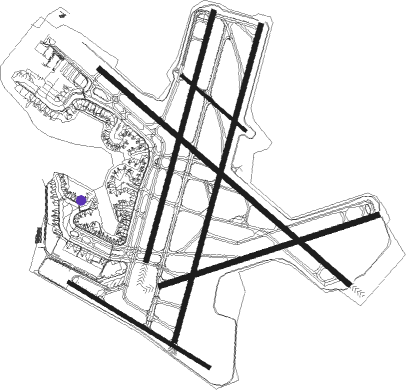
Taxiway locations
Parking locations
|
Nearby beacons
| code | identifier | dist | bearing | frequency |
|---|---|---|---|---|
| BOS | BOSTON VOR/DME | 0.8 | 108° | 112.70 |
| OW | STOGE (NORWOOD) NDB | 15.5 | 207° | 397 |
| LWM | DME | 23 | 347° | 112.50 |
| MHT | MANCHESTER VOR/DME | 34.3 | 324° | 114.40 |
| MJ | FITZY (MANCHESTER) NDB | 37.9 | 314° | 209 |
| PVC | PROVINCETOWN NDB | 39 | 111° | 389 |
| PVD | PROVIDENCE VOR/DME | 42.7 | 214° | 115.60 |
| PSM | (PORTSMOUTH) DME | 44 | 14° | 116.50 |
| PUT | PUTNAM VOR/DME | 44.6 | 244° | 117.40 |
| FMH | OTIS (FALMOUTH) TACAN | 47.6 | 145° | 115.80 |
| LFV | MARCONI (NORTH TRURO) VOR/DME | 47.8 | 110° | 114.70 |
| CO | EPSOM (CONCORD) NDB | 49.4 | 329° | 216 |
| ESG | ROLLINS (ROLLINSFORD) NDB | 52 | 12° | 260 |
| HY | BOGEY (HYANNIS) NDB | 52.8 | 129° | 342 |
| CON | CONCORD VOR/DME | 57.2 | 326° | 112.90 |
| SF | SANFD (SANFORD) NDB | 58.8 | 10° | 349 |
| MVY | MARTHA'S VINEYARD VOR/DME | 60.6 | 158° | 114.50 |
| ORW | NORWICH VOR/DME | 65.6 | 231° | 110 |
Departure and arrival routes
| Transition altitude | 18000ft |
| Transition level | 18000ft |
| SID end points | distance | outbound heading | |
|---|---|---|---|
| RW04 (ALL) | |||
| LOGAN3 | 30mi | 261° | |
| RW04R | |||
| LBSTA7 | 31mi | 42° | |
| CELTK6 | 41mi | 96° | |
| BRUWN6 | 57mi | 134° | |
| SSOXS6 | 34mi | 154° | |
| PATSS6 | 35mi | 249° | |
| BLZZR5 | 35mi | 259° | |
| REVSS5 | 36mi | 269° | |
| HYLND6 | 28mi | 327° | |
| RW09 | |||
| LBSTA7 | 31mi | 42° | |
| CELTK6 | 41mi | 96° | |
| BRUWN6 | 57mi | 134° | |
| SSOXS6 | 34mi | 154° | |
| PATSS6 | 35mi | 249° | |
| BLZZR5 | 35mi | 259° | |
| LOGAN3 | 30mi | 261° | |
| REVSS5 | 36mi | 269° | |
| HYLND6 | 28mi | 327° | |
| RW14 | |||
| LOGAN3 | 30mi | 261° | |
| RW15R | |||
| LBSTA7 | 31mi | 42° | |
| CELTK6 | 41mi | 96° | |
| BRUWN6 | 57mi | 134° | |
| SSOXS6 | 34mi | 154° | |
| PATSS6 | 35mi | 249° | |
| BLZZR5 | 35mi | 259° | |
| LOGAN3 | 30mi | 261° | |
| REVSS5 | 36mi | 269° | |
| HYLND6 | 28mi | 327° | |
| RW22 (ALL) | |||
| LOGAN3 | 30mi | 261° | |
| RW22L | |||
| LBSTA7 | 31mi | 42° | |
| CELTK6 | 41mi | 96° | |
| BRUWN6 | 57mi | 134° | |
| SSOXS6 | 34mi | 154° | |
| PATSS6 | 35mi | 249° | |
| BLZZR5 | 35mi | 259° | |
| REVSS5 | 36mi | 269° | |
| HYLND6 | 28mi | 327° | |
| RW22R | |||
| LBSTA7 | 31mi | 42° | |
| CELTK6 | 41mi | 96° | |
| BRUWN6 | 57mi | 134° | |
| SSOXS6 | 34mi | 154° | |
| PATSS6 | 35mi | 249° | |
| BLZZR5 | 35mi | 259° | |
| REVSS5 | 36mi | 269° | |
| HYLND6 | 28mi | 327° | |
| RW27 | |||
| LBSTA7 | 31mi | 42° | |
| CELTK6 | 41mi | 96° | |
| BRUWN6 | 57mi | 134° | |
| SSOXS6 | 34mi | 154° | |
| WYLYY4 | 17mi | 231° | |
| PATSS6 | 35mi | 249° | |
| BLZZR5 | 35mi | 259° | |
| LOGAN3 | 30mi | 261° | |
| REVSS5 | 36mi | 269° | |
| HYLND6 | 28mi | 327° | |
| RW33L | |||
| LBSTA7 | 31mi | 42° | |
| CELTK6 | 41mi | 96° | |
| BRUWN6 | 57mi | 134° | |
| SSOXS6 | 34mi | 154° | |
| PATSS6 | 35mi | 249° | |
| BLZZR5 | 35mi | 259° | |
| LOGAN3 | 30mi | 261° | |
| REVSS5 | 36mi | 269° | |
| HYLND6 | 28mi | 327° | |
| STAR starting points | distance | inbound heading | |
|---|---|---|---|
| ALL | |||
| ORW7 | 42.7 | 34° | |
| WOONS2 | 65.6 | 51° | |
| GDM4 | 47.8 | 100° | |
| RW04 (ALL) | |||
| JFUND2 | 38.5 | 105° | |
| OOSHN5 | 37.2 | 253° | |
| RW04L | |||
| ROBUC3 | 36.8 | 26° | |
| RW04R | |||
| ROBUC3 | 36.8 | 26° | |
| RW15R | |||
| ROBUC3 | 36.8 | 26° | |
| JFUND2 | 38.5 | 105° | |
| OOSHN5 | 37.2 | 253° | |
| RW22 (ALL) | |||
| ROBUC3 | 36.8 | 26° | |
| JFUND2 | 38.5 | 105° | |
| OOSHN5 | 37.2 | 253° | |
| RW27 | |||
| ROBUC3 | 36.8 | 26° | |
| JFUND2 | 38.5 | 105° | |
| OOSHN5 | 37.2 | 253° | |
| RW32 | |||
| ROBUC3 | 36.8 | 26° | |
| JFUND2 | 38.5 | 105° | |
| OOSHN5 | 37.2 | 253° | |
| RW33L | |||
| ROBUC3 | 36.8 | 26° | |
| JFUND2 | 38.5 | 105° | |
| OOSHN5 | 37.2 | 253° | |
Instrument approach procedures
| runway | airway (heading) | route (dist, bearing) |
|---|---|---|
| RW04R | GOSHI (26°) | GOSHI 6000ft WINNI (5mi, 26°) 4000ft |
| RNAV | WINNI 4000ft NABBO (5mi, 26°) 3000ft MILTT (5mi, 26°) 1700ft IRSEW (3mi, 26°) 700ft KBOS (3mi, 25°) 69ft (4569mi, 121°) 218ft OMVOZ (4569mi, 301°) WAXEN (12mi, 22°) 3000ft WAXEN (turn) | |
| RW15R | AADMS (125°) | AADMS 5000ft ZOMIB (5mi, 121°) 4000ft |
| RW15R | GDM (100°) | GDM ZOMIB (36mi, 91°) 4000ft |
| RNAV | ZOMIB 4000ft WIDUP (5mi, 127°) 3000ft EMMEL (4mi, 127°) 1700ft KBOS (6mi, 128°) 77ft (4569mi, 121°) 217ft HUBIR (4567mi, 301°) CELTS (10mi, 129°) 3000ft CELTS (turn) | |
| RW27 | AYBEE (261°) | AYBEE 6000ft KLANE (7mi, 260°) 4000ft LONER (4mi, 260°) 3000ft |
| RNAV | LONER 3000ft RIPIT (5mi, 260°) 1700ft KBOS (6mi, 263°) 72ft (4569mi, 121°) 419ft WANTU (4571mi, 301°) BOSOX (27mi, 256°) 3000ft BOSOX (turn) | |
| RW32 | FREDO (317°) | FREDO DUNKK (11mi, 337°) 4000ft HAVRD (7mi, 307°) 4000ft YAARD (4mi, 307°) 3000ft |
| RW32 | INNDY (9°) | INNDY QUINC (21mi, 55°) 4000ft DUNKK (6mi, 54°) 4000ft HAVRD (7mi, 307°) 4000ft YAARD (4mi, 307°) 3000ft |
| RW32 | SCUPP (253°) | SCUPP BOATZ (31mi, 216°) 4000ft DUNKK (6mi, 234°) 4000ft HAVRD (7mi, 307°) 4000ft YAARD (4mi, 307°) 3000ft |
| RW32 | WOONS (51°) | WOONS QUINC (34mi, 85°) 4000ft DUNKK (6mi, 54°) 4000ft HAVRD (7mi, 307°) 4000ft YAARD (4mi, 307°) 3000ft |
| RNAV | YAARD 3000ft BGDIG (6mi, 307°) 1500ft PAARK (4mi, 307°) 204ft (4569mi, 121°) 419ft WINDZ (4571mi, 301°) TELLE (19mi, 269°) 3000ft TELLE (turn) |
Holding patterns
| STAR name | hold at | type | turn | heading* | altitude | leg | speed limit |
|---|---|---|---|---|---|---|---|
| GDM4 | GDM | NDB | left | 294 (114)° | 1.0min timed | ICAO rules | |
| JFUND2 | JFUND | VHF | left | 297 (117)° | DME 10.0mi | ICAO rules | |
| JFUND2 | ONDEC | VHF | left | 293 (113)° | DME 15.0mi | ICAO rules | |
| JFUND2 | SEETS | VHF | right | 294 (114)° | DME 15.0mi | 230 | |
| OOSHN5 | AJJAY | VHF | left | 37 (217)° | < 60000ft | DME 20.0mi | ICAO rules |
| OOSHN5 | ENE | NDB | left | 44 (224)° | 1.5min timed | ICAO rules | |
| OOSHN5 | FERNZ | VHF | right | 179 (359)° | < 60000ft | DME 20.0mi | ICAO rules |
| OOSHN5 | LONEY | VHF | right | 182 (2)° | DME 10.0mi | ICAO rules | |
| OOSHN5 | OOSHN | VHF | right | 80 (260)° | DME 20.0mi | ICAO rules | |
| ORW7 | PVD | NDB | right | 234 (54)° | 1.0min timed | ICAO rules | |
| ROBUC3 | BANKI | VHF | right | 263 (83)° | DME 10.0mi | ICAO rules | |
| ROBUC3 | JOODY | VHF | left | 255 (75)° | DME 10.0mi | ICAO rules | |
| ROBUC3 | PROVI | VHF | right | 234 (54)° | DME 10.0mi | ICAO rules | |
| WOONS2 | ORW | NDB | left | 238 (58)° | 2500ft - 17500ft | 1.0min timed | ICAO rules |
| WOONS2 | WOONS | VHF | left | 240 (60)° | < 17999ft | 1.0min timed | ICAO rules |
| *) magnetic outbound (inbound) holding course | |||||||
Disclaimer
The information on this website is not for real aviation. Use this data with the X-Plane flight simulator only! Data taken with kind consent from X-Plane 12 source code and data files. Content is subject to change without notice.