Caldwell - Essex County
Airport details
| Country | United States of America |
| State | New Jersey |
| Region | K6 |
| Airspace | New York Ctr |
| Municipality | Fairfield |
| Elevation | 170ft (52m) |
| Timezone | GMT -5 |
| Coordinates | 40.87522, -74.28136 |
| Magnetic var | |
| Type | land |
| Available since | X-Plane v10.40 |
| ICAO code | KCDW |
| IATA code | CDW |
| FAA code | CDW |
Communication
| Essex County ATIS | 135.500 |
| Essex County CTAF | 119.800 |
| Essex County UNICOM | 122.950 |
| Essex County Clearance DEL | 121.100 |
| Essex County Ground Control | 121.900 |
| Essex County Tower | 119.800 |
| Essex County NEW YORK Approach | 127.600 |
| Essex County NEW YORK Departure | 119.200 |
Approach frequencies
| LOC | RW22 | 109.35 | 18.00mi |
Nearby Points of Interest:
Fairfield Dutch Reformed Church
-Canfield-Morgan House
-Jacobus House
-Samuel Orton Harrison House
-Anderson Park
-Williams-Harrison House
-Reynier Speer House
-Post Office Building, Upper Montclair
-Van Reyper-Bond House
-Cliffside Hose Company No. 4
-J. M. Chapman House
-Free Public Library, Upper Montclair Branch
-Casa Deldra
-Egbert Farm
-Parsonage of the Montville Reformed Dutch Church
-Von Schmid House
-John and Anna Vreeland House
-Eastward
-Charles S. Shultz House
-The Anchorage
-The House that Lives
-Bradner's Pharmacy
-Carnegie Library
-Stone Eagles
-Crane House and Museum
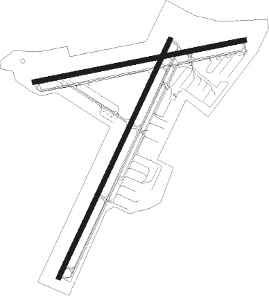
Runway info
Runway 4 / 22  | ||
| length | 1389m (4557ft) | |
| bearing | 37° / 217° | |
| width | 25m (82ft) | |
| surface | asphalt | |
| displ threshold | 115m (377ft) / 41m (135ft) | |
| Runway 10 / 28 | ||
| length | 1131m (3711ft) | |
| bearing | 85° / 265° | |
| width | 25m (82ft) | |
| surface | asphalt | |
| displ threshold | 105m (344ft) / 168m (551ft) | |
Nearby beacons
| code | identifier | dist | bearing | frequency |
|---|---|---|---|---|
| MM | MOREE (MORRISTOWN) NDB | 2.4 | 275° | 392 |
| TE | TORBY (TETERBORO) NDB | 7.9 | 115° | 214 |
| TEB | TETERBORO VOR/DME | 10 | 97° | 108.40 |
| CAT | CHATHAM NDB | 10.5 | 228° | 254 |
| SAX | SPARTA VORTAC | 16.4 | 307° | 115.70 |
| LGA | LA GUARDIA (NEW YORK) VOR/DME | 19.5 | 102° | 113.10 |
| CRI | CANARSIE VOR/DME | 23.6 | 124° | 112.30 |
| BWZ | BROADWAY (SCHOOLEY'S MT) VOR/DME | 24.9 | 262° | 114.20 |
| JFK | KENNEDY (NEW YORK) VOR/DME | 27.3 | 115° | 115.90 |
| SBJ | SOLBERG VOR/DME | 27.3 | 238° | 112.90 |
| STW | STILLWATER VOR/DME | 27.6 | 282° | 109.60 |
| COL | COLTS NECK VOR/DME | 34.2 | 168° | 115.40 |
| HUO | HUGUENOT VOR/DME | 35 | 330° | 116.10 |
| FR | FRIKK (FARMINGDALE) NDB | 36.7 | 97° | 407 |
| SW | NEELY (NEWBURGH) NDB | 36.7 | 5° | 335 |
| CMK | CARMEL VOR/DME | 39.9 | 60° | 116.60 |
| SKU | STANWYCK (NEWBURGH) NDB | 40.6 | 20° | 261 |
| RBV | ROBBINSVILLE VORTAC | 41.5 | 198° | 113.80 |
| DPK | DEER PARK VOR/DME | 44.7 | 95° | 117.70 |
| ARD | YARDLEY VOR/DME | 47 | 225° | 108.20 |
| NEL | LAKEHURST NDB | 49.9 | 184° | 396 |
| NEL | LAKEHURST TACAN | 50.4 | 185° | 111.80 |
| IGN | KINGSTON VOR/DME | 51.7 | 30° | 117.60 |
| GXU | MC GUIRE (WRIGHTSTOWN) VORTAC | 53.9 | 200° | 110.60 |
| PWL | PAWLING (POUGHKEEPSIE) VOR/DME | 61.8 | 37° | 114.30 |
Departure and arrival routes
| Transition altitude | 18000ft |
| Transition level | 18000ft |
| STAR starting points | distance | inbound heading | |
|---|---|---|---|
| ALL | |||
| JAIKE3 | 89.1 | 51° | |
| MAZIE3 | 50.3 | 56° | |
| LVZ4 | 68.0 | 106° | |
Instrument approach procedures
| runway | airway (heading) | route (dist, bearing) |
|---|---|---|
| RW04 | SAX (127°) | SAX YOVUN (23mi, 161°) 2700ft YOVUN (turn) 2700ft |
| RW04 | SBJ (58°) | SBJ YOVUN (17mi, 71°) 2700ft |
| RNAV | YOVUN 2700ft ZOGUD (6mi, 37°) 2000ft WISAL (3mi, 37°) 1140ft KCDW (3mi, 36°) 222ft (4695mi, 119°) 572ft JIRBO (4691mi, 299°) 2700ft JIRBO (turn) | |
| RW10 | SAX (127°) | SAX WOKPU (13mi, 181°) 2700ft WOKPU (turn) 2700ft |
| RW10 | SBJ (58°) | SBJ WOKPU (19mi, 37°) 2700ft |
| RNAV | WOKPU 2700ft HILKI (3mi, 85°) 2400ft SULOY (3mi, 85°) 2000ft ZIRID (3mi, 85°) 940ft KCDW (3mi, 87°) 219ft (4695mi, 119°) 572ft WOKPU (4707mi, 299°) 2700ft WOKPU (turn) | |
| RW22 | APART (187°) | APART DOWDY (6mi, 135°) 2400ft |
| RW22 | WELDD (165°) | WELDD APART (4mi, 102°) 3000ft DOWDY (6mi, 135°) 2400ft |
| RW22 | ZEZEE (150°) | ZEZEE WELDD (4mi, 102°) 3000ft APART (4mi, 102°) 3000ft DOWDY (6mi, 135°) 2400ft |
| RNAV | DOWDY 2400ft FAAIR (4mi, 217°) 2000ft KOLLI (3mi, 217°) 1000ft KCDW (3mi, 217°) 230ft (4695mi, 119°) 459ft YOVUN (4699mi, 299°) 2000ft YOVUN (turn) |
Holding patterns
| STAR name | hold at | type | turn | heading* | altitude | leg | speed limit |
|---|---|---|---|---|---|---|---|
| JAIKE3 | MAZIE | VHF | left | 237 (57)° | < 17999ft | 1.0min timed | 210 |
| JAIKE3 | PALEO | VHF | left | 232 (52)° | < 45000ft | 1.5min timed | ICAO rules |
| JAIKE3 | SPNCR | VHF | right | 227 (47)° | 6001ft - 14000ft | DME 4.0mi | 210 |
| LVZ4 | HARTY | VHF | left | 305 (125)° | 18000ft - 45000ft | 1.5min timed | ICAO rules |
| LVZ4 | HOXIE | VHF | left | 295 (115)° | 18000ft - 45000ft | DME 6.0mi | ICAO rules |
| LVZ4 | MUGZY | VHF | left | 305 (125)° | 6001ft - 14000ft | 1.0min timed | 210 |
| MAZIE3 | BACKY | VHF | right | 216 (36)° | DME 7.0mi | ICAO rules | |
| MAZIE3 | MAZIE | VHF | left | 237 (57)° | < 17999ft | 1.0min timed | 210 |
| MAZIE3 | RAZER | VHF | right | 229 (49)° | < 60000ft | DME 6.0mi | 210 |
| *) magnetic outbound (inbound) holding course | |||||||
Disclaimer
The information on this website is not for real aviation. Use this data with the X-Plane flight simulator only! Data taken with kind consent from X-Plane 12 source code and data files. Content is subject to change without notice.