Chicago/west Chicago - Du Page
Airport details
| Country | United States of America |
| State | Illinois |
| Region | K5 |
| Airspace | Chicago Ctr |
| Municipality | West Chicago |
| Elevation | 756ft (230m) |
| Timezone | GMT -6 |
| Coordinates | 41.90705, -88.24800 |
| Magnetic var | |
| Type | land |
| Available since | X-Plane v10.40 |
| ICAO code | KDPA |
| IATA code | DPA |
| FAA code | DPA |
Communication
| Du Page ATIS | 132.075 |
| Du Page UNICOM | 122.950 |
| Du Page Clearance DEL | 119.750 |
| Du Page Ground Control | 121.800 |
| Du Page Tower | 120.900 |
| Du Page CHICAGO Approach/Departure | 133.500 |
Approach frequencies
| ILS-cat-I | RW10 | 109.5 | 18.00mi |
| ILS-cat-I | RW02L | 111.7 | 18.00mi |
| 3° GS | RW10 | 109.5 | 18.00mi |
| 3° GS | RW02L | 111.7 | 18.00mi |
Nearby Points of Interest:
West Chicago City Museum
-Wayne Village Historic District
-Oaklawn Farm
-Hunt House
-North Geneva Historic District
-Andrew Weisel House
-Joel H. Hubbard House
-Central Geneva Historic District
-Pure Oil Station
-Elizabeth Place
-Geneva Country Day School
-Fabyan Villa
-Riverbank Laboratories
-Mrs. A. W. Gridley House
-Judge Isaac Wilson House
-Eastside Community Center
-Louise White School
-First Methodist Church of Batavia
-Durant House
-Batavia Institute
-Grand Theatre
-DuPage County Courthouse
-Blanchard Hall
-Ora Pelton House
-Gifford-Davidson House
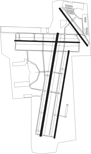
Runway info
Runway 2L / 20R  | ||
| length | 2310m (7579ft) | |
| bearing | 19° / 199° | |
| width | 46m (150ft) | |
| surface | concrete | |
| Runway 2R / 20L | ||
| length | 1968m (6457ft) | |
| bearing | 18° / 198° | |
| width | 30m (100ft) | |
| surface | concrete | |
| Runway 10 / 28 | ||
| length | 1449m (4754ft) | |
| bearing | 94° / 274° | |
| width | 23m (75ft) | |
| surface | asphalt | |
| Runway 15 / 33 | ||
| length | 1037m (3402ft) | |
| bearing | 140° / 320° | |
| width | 30m (100ft) | |
| surface | asphalt | |
| displ threshold | 0m (0ft) / 58m (190ft) | |
| blast zone | 0m (0ft) / 58m (190ft) | |
Nearby beacons
| code | identifier | dist | bearing | frequency |
|---|---|---|---|---|
| DPA | DUPAGE (CHICAGO) VOR/DME | 4.6 | 261° | 108.40 |
| GCO | DME | 16.3 | 76° | 108.25 |
| JOT | JOLIET VOR/DME | 21.8 | 191° | 112.30 |
| OBK | NORTHBROOK VOR/DME | 23 | 43° | 113 |
| MX | KEDZI (CHICAGO) NDB | 26.8 | 107° | 248 |
| CGT | CHICAGO HEIGHTS VORTAC | 38.5 | 120° | 114.20 |
| UG | WAUKE (CHICAGO/WAUKEGAN) NDB | 38.9 | 39° | 379 |
| EON | PEOTONE VORTAC | 43.4 | 144° | 113.20 |
| ENW | DME | 43.8 | 25° | 109.20 |
| GY | GARIE (GARY) NDB | 45.8 | 110° | 236 |
| RFD | DME | 46.5 | 289° | 110.80 |
| BUU | (BURLINGTON) DME | 47 | 356° | 114.50 |
| DTG | DWIGHT NDB | 47.2 | 194° | 344 |
| RA | PASER (RACINE) NDB | 49 | 24° | 206 |
| IKK | DME | 53.1 | 154° | 111.60 |
| JVL | JANESVILLE VOR/DME | 54.6 | 307° | 114.30 |
| HRK | (RACINE) DME | 54.8 | 27° | 117.70 |
| IK | LUKOW (KANKAKEE) NDB | 55.6 | 159° | 272 |
Departure and arrival routes
| Transition altitude | 18000ft |
| Transition level | 18000ft |
| SID end points | distance | outbound heading | |
|---|---|---|---|
| RW02 (ALL) | |||
| ELANR6 | 126mi | 150° | |
| DARCY6 | 176mi | 153° | |
| CARYN6 | 97mi | 166° | |
| BLOKR6 | 80mi | 176° | |
| ADELL6 | 97mi | 195° | |
| OBENE3 | 201mi | 281° | |
| RW10 | |||
| ELANR6 | 126mi | 150° | |
| DARCY6 | 176mi | 153° | |
| CARYN6 | 97mi | 166° | |
| BLOKR6 | 80mi | 176° | |
| ADELL6 | 97mi | 195° | |
| OBENE3 | 201mi | 281° | |
| RW15 | |||
| ELANR6 | 126mi | 150° | |
| DARCY6 | 176mi | 153° | |
| CARYN6 | 97mi | 166° | |
| BLOKR6 | 80mi | 176° | |
| ADELL6 | 97mi | 195° | |
| OBENE3 | 201mi | 281° | |
| RW20 (ALL) | |||
| ELANR6 | 126mi | 150° | |
| DARCY6 | 176mi | 153° | |
| CARYN6 | 97mi | 166° | |
| BLOKR6 | 80mi | 176° | |
| ADELL6 | 97mi | 195° | |
| OBENE3 | 201mi | 281° | |
| RW28 | |||
| ELANR6 | 126mi | 150° | |
| DARCY6 | 176mi | 153° | |
| CARYN6 | 97mi | 166° | |
| BLOKR6 | 80mi | 176° | |
| ADELL6 | 97mi | 195° | |
| OBENE3 | 201mi | 281° | |
| RW33 | |||
| ELANR6 | 126mi | 150° | |
| DARCY6 | 176mi | 153° | |
| CARYN6 | 97mi | 166° | |
| BLOKR6 | 80mi | 176° | |
| ADELL6 | 97mi | 195° | |
| OBENE3 | 201mi | 281° | |
Instrument approach procedures
| runway | airway (heading) | route (dist, bearing) |
|---|---|---|
| RW02L | BOMER (19°) | BOMER 3000ft |
| RW02L | JOT (11°) | JOT BOMER (10mi, 1°) 3000ft |
| RW02L | PLANO (51°) | PLANO CEXAB (8mi, 88°) 3000ft BOMER (8mi, 53°) 3000ft |
| RNAV | BOMER 3000ft ZETKO (6mi, 18°) 2500ft KDPA (6mi, 19°) 801ft (5327mi, 115°) 1300ft NUELG (5345mi, 295°) 3000ft NUELG (turn) | |
| RW02R | GIDVE (18°) | GIDVE 3000ft |
| RW02R | JOT (11°) | JOT GIDVE (9mi, 1°) 3000ft |
| RW02R | PLANO (51°) | PLANO CEXAB (8mi, 88°) 3000ft GIDVE (7mi, 58°) 3000ft |
| RNAV | GIDVE 3000ft HEGBI (7mi, 18°) 2500ft KDPA (6mi, 17°) 800ft (5327mi, 115°) 1300ft NUELG (5345mi, 295°) 3000ft NUELG (turn) | |
| RW10 | DPA (81°) | DPA NUMIZ (8mi, 285°) 2600ft NUMIZ (turn) 2600ft |
| RW10 | HINCK (79°) | HINCK NUMIZ (10mi, 56°) 2600ft |
| RW10 | NUELG (101°) | NUELG NUMIZ (7mi, 110°) 2600ft |
| RNAV | NUMIZ 2600ft HOSAV (6mi, 94°) 2600ft KOHYO (4mi, 94°) 1400ft KDPA (2mi, 100°) 803ft (5327mi, 115°) 956ft PEPRE (5321mi, 295°) JOT (23mi, 209°) 2600ft JOT (turn) | |
| RW20L | DPA (81°) | DPA JOLON (15mi, 39°) 3000ft JOLON (turn) 3000ft |
| RW20L | FARMM (165°) | FARMM JOLON (16mi, 143°) 3000ft |
| RW20L | NUELG (101°) | NUELG JOLON (22mi, 77°) 3000ft JOLON (turn) 3000ft |
| RNAV | JOLON 3000ft ZOGUB (6mi, 199°) 2500ft PECBI (3mi, 199°) 1400ft KDPA (2mi, 202°) 799ft (5327mi, 115°) 1159ft GIDVE (5330mi, 295°) JOT (9mi, 181°) 2500ft JOT (turn) | |
| RW20R | DPA (81°) | DPA DUKBE (15mi, 38°) 3000ft DUKBE (turn) 3000ft |
| RW20R | FARMM (165°) | FARMM DUKBE (16mi, 143°) 3000ft |
| RW20R | NUELG (101°) | NUELG DUKBE (22mi, 76°) 3000ft DUKBE (turn) 3000ft |
| RNAV | DUKBE 3000ft FRTZZ (6mi, 199°) 2500ft SUCOP (4mi, 199°) 1360ft KDPA (2mi, 197°) 796ft (5327mi, 115°) 1043ft FABUG (5328mi, 295°) JOT (16mi, 188°) 2500ft JOT (turn) |
Disclaimer
The information on this website is not for real aviation. Use this data with the X-Plane flight simulator only! Data taken with kind consent from X-Plane 12 source code and data files. Content is subject to change without notice.