Dansville - Dansville Muni
Airport details
| Country | United States of America |
| State | New York |
| Region | K6 |
| Airspace | Cleveland Ctr |
| Municipality | Town of North Dansville |
| Elevation | 662ft (202m) |
| Timezone | GMT -5 |
| Coordinates | 42.57069, -77.71297 |
| Magnetic var | |
| Type | land |
| Available since | X-Plane v10.40 |
| ICAO code | KDSV |
| IATA code | DSV |
| FAA code | DSV |
Communication
| Dansville Muni ASOS | 118.325 |
| Dansville Muni CTAF/UNICOM | 123.000 |
| Dansville Muni ROCHESTER Approach/Departure | 123.700 |
Nearby Points of Interest:
William Hartman Farmstead
-Dansville Library
-United States Post Office
-Pioneer Farm
-Engleside
-Elias H. Geiger House
-Sparta First Presbyterian Church
-Black and White Farm Barn
-First Presbyterian Church of Tuscarora
-Sliker Cobblestone House
-Conesus Amusement Hall
-Kellerman Log Cabin
-Elmwood
-Payne Cobblestone House
-Union Block
-Larrowe House
-Presbyterian Church of Atlanta
-House at No. 176 South Main Street
-South Main Street Historic District
-Edgerley
-House at No. 30 Murray Street
-New Family Theater
-House at No. 8 State Street
-St. John's Episcopal Church
-State and Eagle Streets Historic District
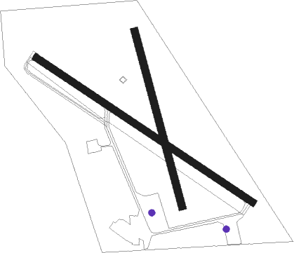
Runway info
Runway 14 / 32  | ||
| length | 1068m (3504ft) | |
| bearing | 120° / 300° | |
| width | 30m (100ft) | |
| surface | asphalt | |
| Runway 18 / 36 | ||
| length | 744m (2441ft) | |
| bearing | 166° / 346° | |
| width | 30m (100ft) | |
| surface | grass | |
| displ threshold | 51m (167ft) / 0m (0ft) | |
Nearby beacons
| code | identifier | dist | bearing | frequency |
|---|---|---|---|---|
| GEE | GENESEO VOR/DME | 15.8 | 356° | 108.20 |
| PYA | PENN YAN NDB | 29.3 | 84° | 260 |
| ELZ | DME | 31.5 | 211° | 111.40 |
| ROC | ROCHESTER VOR/DME | 32.9 | 4° | 110 |
| ULW | ELMIRA VOR/DME | 41.8 | 125° | 109.65 |
| BUF | BUFFALO VOR/DME | 46.4 | 291° | 116.40 |
| ALP | ALPINE (ELMIRA) NDB | 46.5 | 109° | 245 |
| BU | KLUMP (BUFFALO) NDB | 48.7 | 295° | 231 |
| SFK | STONYFORK VOR/DME | 54.1 | 161° | 108.60 |
| BFD | DME | 62 | 229° | 116.60 |
Instrument approach procedures
| runway | airway (heading) | route (dist, bearing) |
|---|---|---|
| RW14 | BENEE (85°) | BENEE YODUK (18mi, 65°) 4000ft VEBUC (5mi, 60°) 3300ft UDECA (3mi, 133°) 2900ft |
| RW14 | VEBUC (132°) | VEBUC 3300ft UDECA (3mi, 133°) 2900ft |
| RW14 | WELTI (153°) | WELTI WUSAT (9mi, 146°) 4000ft VEBUC (5mi, 240°) 3300ft UDECA (3mi, 133°) 2900ft |
| RNAV | UDECA 2900ft UDOPE (3mi, 133°) 2600ft YICUP (6mi, 133°) 828ft (4864mi, 119°) 1060ft VEBUC (4873mi, 299°) 3500ft VEBUC (turn) | |
| RWNVA | HORNE (325°) | HORNE 3700ft |
| RNAV | HORNE 3700ft WELMO (8mi, 325°) 3200ft VETUC (4mi, 326°) 2220ft (4863mi, 119°) 2220ft WITMA (4865mi, 299°) WOTIP (10mi, 352°) 3300ft WOTIP (turn) |
Disclaimer
The information on this website is not for real aviation. Use this data with the X-Plane flight simulator only! Data taken with kind consent from X-Plane 12 source code and data files. Content is subject to change without notice.