Monroe - Monroe Muni
Airport details
| Country | United States of America |
| State | Wisconsin |
| Region | K5 |
| Airspace | Chicago Ctr |
| Municipality | Monroe |
| Elevation | 1084ft (330m) |
| Timezone | GMT -6 |
| Coordinates | 42.61490, -89.59040 |
| Magnetic var | |
| Type | land |
| Available since | X-Plane v10.40 |
| ICAO code | KEFT |
| IATA code | n/a |
| FAA code | EFT |
Communication
| Monroe Muni AWOS 3 | 118.375 |
| Monroe Muni CTAF/UNICOM | 123.050 |
| Monroe Muni ROCKFORD Approach/Departure | 126.000 |
Nearby Points of Interest:
Janet Jennings House
-Jacob Regez, Sr. House
-Gen. James Bintliff House
-Green County Courthouse
-General Francis H. West House
-Monroe Commercial District
-Freitag's Pure Oil Service Station
-First Methodist Church
-Monroe Water Tower
-Charles Fehr Round Barn
-People's State Bank
-AF and AM Lodge 687
-Union House
-Francis West Smith House
-William Ritzman House
-Hefty–Blum Farmstead
-Cleveland's Hall and Blacksmith Shop
-West Luther Valley Lutheran Church
-Dr. Samuel Blumer House
-Risum Round Barn
-Star Theater
-John H. Addams Homestead
-Orfordville Depot
-Francis Marian Ames Farmstead
-Dennis Otte Round Barn
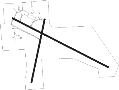
Runway info
Runway 12 / 30  | ||
| length | 1522m (4993ft) | |
| bearing | 115° / 295° | |
| width | 23m (75ft) | |
| surface | asphalt | |
| blast zone | 91m (299ft) / 0m (0ft) | |
| Runway 2 / 20 | ||
| length | 915m (3002ft) | |
| bearing | 22° / 202° | |
| width | 23m (75ft) | |
| surface | asphalt | |
| blast zone | 64m (210ft) / 137m (449ft) | |
Nearby beacons
| code | identifier | dist | bearing | frequency |
|---|---|---|---|---|
| JVL | JANESVILLE VOR/DME | 21.7 | 97° | 114.30 |
| RFD | DME | 29.1 | 135° | 110.80 |
| MSN | MADISON VORTAC | 33.6 | 25° | 108.60 |
| PLL | POLO VOR/DME | 39.1 | 174° | 111.20 |
| LNR | ROCK DME | 47.2 | 321° | 116.05 |
| RYV | ROCK RIVER (WATERTOWN) NDB | 50.7 | 57° | 371 |
| DLL | DELLS (BARABOO) VORTAC | 56.7 | 350° | 117 |
| UNU | JUNEAU NDB | 62.5 | 47° | 344 |
| FN | HILLZ (CLINTON) NDB | 62.8 | 223° | 517 |
| CVA | DAVENPORT VORTAC | 67.4 | 225° | 113.80 |
Instrument approach procedures
| runway | airway (heading) | route (dist, bearing) |
|---|---|---|
| RW12 | BAULK (97°) | BAULK NUBUE (15mi, 97°) 3000ft ALOOF (5mi, 39°) 3000ft |
| RW12 | DALEY (146°) | DALEY MARKM (7mi, 162°) 3000ft ALOOF (5mi, 220°) 3000ft |
| RW12 | MADDY (58°) | MADDY NUBUE (10mi, 329°) 3000ft ALOOF (5mi, 39°) 3000ft |
| RNAV | ALOOF 3000ft IGOGY (6mi, 114°) 2700ft KEFT (5mi, 115°) 1126ft FALKN (3mi, 113°) DAVIS (11mi, 134°) 3000ft DAVIS (turn) | |
| RW30 | DAVIS (310°) | DAVIS XOTIY (5mi, 13°) 3000ft |
| RW30 | GENZU (276°) | GENZU XOTIY (5mi, 220°) 3000ft |
| RNAV | XOTIY 3000ft ZEBRU (6mi, 294°) 2700ft KEFT (5mi, 294°) 1104ft (5387mi, 115°) 1490ft DAVIS (5378mi, 295°) 3000ft DAVIS (turn) |
Disclaimer
The information on this website is not for real aviation. Use this data with the X-Plane flight simulator only! Data taken with kind consent from X-Plane 12 source code and data files. Content is subject to change without notice.