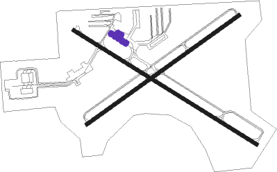
West Bend - West Bend Muni
Airport details
| Country | United States of America |
| State | Wisconsin |
| Region | K5 |
| Airspace | Chicago Ctr |
| Municipality | West Bend |
| Elevation | 887ft (270m) |
| Timezone | GMT -6 |
| Coordinates | 43.42192, -88.13332 |
| Magnetic var | |
| Type | land |
| Available since | X-Plane v10.40 |
| ICAO code | KETB |
| IATA code | ETB |
| FAA code | ETB |
Communication
| West Bend Muni AWOS 3 | 120.000 |
| West Bend Muni CTAF/UNICOM | 122.800 |
| West Bend Muni MILWAUKEE Approach/Departure | 125.350 |
Nearby Points of Interest:
Washington County Courthouse and Jail
-Lizard Mound County Park
-St. Peter's Church
-St. Augustine Catholic Church and Cemetery
-St. John of God Roman Catholic Church, Convent, and School
-Kneeland-Walker House
-Saint John Evangelical Lutheran Church
-Christian Turck House
-St. Matthias Mission
-Hilgen and Wittenberg Woolen Mill
-Washington Avenue Historic District
-Cedarburg Mill
-Wayside House
-Cedarburg Woolen Co. Worsted Mill
-Christ Evangelical Church
-John Reichert Farmhouse
-Concordia Mill
-Harry W. Bolens House
-Gooseville Mill/Grist Mill
-Jonathan Clark House
-Old Ozaukee County Courthouse
-Port Washington Fire Engine House
-St. Mary's Roman Catholic Church
-Edward Dodge House
-Port Washington Downtown Historic District
Nearby beacons
| code | identifier | dist | bearing | frequency |
|---|---|---|---|---|
| BJB | WEST BEND VOR | 0.3 | 90° | 109.80 |
| LJT | (MILWAUKEE) DME | 19.2 | 163° | 115.65 |
| BAE | BADGER (MILWAUKEE) VOR/DME | 19.4 | 206° | 116.40 |
| FAH | (SHEBOYGAN) DME | 24.2 | 39° | 110 |
| UNU | JUNEAU NDB | 24.8 | 271° | 344 |
| RYV | ROCK RIVER (WATERTOWN) NDB | 29.8 | 247° | 371 |
| OS | POBER (OSHKOSH) NDB | 32.8 | 317° | 395 |
| OSH | OSHKOSH VORTAC | 38.7 | 323° | 116.75 |
| HRK | (RACINE) DME | 42 | 154° | 117.70 |
| BUU | (BURLINGTON) DME | 44.6 | 193° | 114.50 |
| RA | PASER (RACINE) NDB | 45.5 | 162° | 206 |
| MTW | DME | 46.7 | 33° | 111 |
| AQ | KOOKY (APPLETON) NDB | 49 | 342° | 407 |
| ENW | DME | 50.2 | 166° | 109.20 |
| MT | MAWOC (MANITOWOC) NDB | 50.3 | 29° | 362 |
| SG | DEPRE (GREEN BAY) NDB | 58.6 | 0° | 332 |
| UG | WAUKE (CHICAGO/WAUKEGAN) NDB | 59.3 | 161° | 379 |
| JVL | JANESVILLE VOR/DME | 67.1 | 228° | 114.30 |
Departure and arrival routes
| Transition altitude | 18000ft |
| Transition level | 18000ft |
| SID end points | distance | outbound heading | |
|---|---|---|---|
| ALL | |||
| UECKR6 | 92mi | 155° | |
| ACCRA5 | 90mi | 176° | |
| STAR starting points | distance | inbound heading | |
|---|---|---|---|
| ALL | |||
| GOPAC2 | 38.3 | 25° | |
Instrument approach procedures
| runway | airway (heading) | route (dist, bearing) |
|---|---|---|
| RW06 | BAE (26°) | BAE LOCMI (8mi, 358°) 2800ft JEDEM (5mi, 320°) 2800ft |
| RW06 | CORIR (100°) | CORIR NUBVE (4mi, 192°) 2800ft JEDEM (5mi, 140°) 2800ft |
| RNAV | JEDEM 2800ft EHULY (6mi, 66°) 2500ft HAXEP (2mi, 66°) 1700ft KETB (2mi, 65°) 931ft KEKSE (12mi, 67°) 3000ft KEKSE (turn) | |
| RW13 | BAE (26°) | BAE EYPUB (22mi, 339°) 3000ft JESIB (5mi, 45°) 3000ft |
| RW13 | HISUB (157°) | HISUB JESIB (11mi, 213°) 3000ft |
| RW13 | JESIB (119°) | JESIB 3000ft |
| RNAV | JESIB 3000ft SEYVY (6mi, 118°) 2700ft EJIZU (3mi, 118°) 1720ft KETB (3mi, 121°) 919ft COVNI (12mi, 118°) 3000ft COVNI (turn) | |
| RW24 | CYNDI (236°) | CYNDI KEKSE (8mi, 217°) 2500ft |
| RW24 | WOKNO (260°) | WOKNO KEKSE (6mi, 287°) 2500ft |
| RNAV | KEKSE 2500ft FIVIX (6mi, 246°) 2500ft ICUMU (2mi, 246°) 1720ft KETB (3mi, 248°) 919ft JEDEM (11mi, 246°) 3000ft JEDEM (turn) | |
| RW31 | BAE (26°) | BAE HIBUN (15mi, 68°) 3000ft COVNI (5mi, 45°) 3000ft |
| RW31 | COVNI (298°) | COVNI 3000ft |
| RW31 | PROOT (304°) | PROOT COVNI (14mi, 309°) 3000ft |
| RW31 | WOKNO (260°) | WOKNO FITSA (7mi, 208°) 3000ft COVNI (5mi, 225°) 3000ft |
| RNAV | COVNI 3000ft HUMBI (6mi, 298°) 2600ft KETB (6mi, 297°) 913ft JESIB (12mi, 299°) 3000ft JESIB (turn) |
Holding patterns
| STAR name | hold at | type | turn | heading* | altitude | leg | speed limit |
|---|---|---|---|---|---|---|---|
| GOPAC2 | LEEDN | VHF | right | 181 (1)° | DME 10.0mi | ICAO rules | |
| GOPAC2 | ZOWRO | VHF | right | 273 (93)° | DME 10.0mi | ICAO rules | |
| *) magnetic outbound (inbound) holding course | |||||||
Disclaimer
The information on this website is not for real aviation. Use this data with the X-Plane flight simulator only! Data taken with kind consent from X-Plane 12 source code and data files. Content is subject to change without notice.

