Minneapolis - Minneapolis Flying Cloud
Airport details
| Country | United States of America |
| State | Minnesota |
| Region | K3 |
| Airspace | Minneapolis Ctr |
| Municipality | Eden Prairie |
| Elevation | 903ft (275m) |
| Timezone | GMT -6 |
| Coordinates | 44.82750, -93.45858 |
| Magnetic var | |
| Type | land |
| Available since | X-Plane v10.40 |
| ICAO code | KFCM |
| IATA code | FCM |
| FAA code | FCM |
Communication
| Minneapolis Flying Cloud ATIS | 124.900 |
| Minneapolis Flying Cloud CTAF | 119.150 |
| Minneapolis Flying Cloud UNICOM | 122.950 |
| Minneapolis Flying Cloud FLYING CLOUD Ground Control | 121.700 |
| Minneapolis Flying Cloud FLYING CLOUD Tower | 119.150 |
| Minneapolis Flying Cloud MINNEAPOLIS Approach | 134.700 |
| Minneapolis Flying Cloud MINNEAPOLIS Departure | 134.700 |
Approach frequencies
| ILS-cat-I | RW10R | 109.7 | 18.00mi |
| 3° GS | RW10R | 109.7 | 18.00mi |
Nearby Points of Interest:
John R. Cummins Farmhouse
-Julius A. Coller House
-Early Shakopee Houses
-Glen Lake Children's Camp
-Church of St. Hubertus-Catholic
-Maka Yusota
-Strunk–Nyssen House
-Wyer House
-Walnut Street Historic District
-Charles H. Burwell House
-Little Rapids Fur Post Historical Marker
-George W. Baird House
-Peter Gideon Farmhouse
-Country Club District
-Bridge No. 90646
-Saint Mary's Church of the Purification
-Chicago, Milwaukee, St. Paul and Pacific Depot
-Jonathan Taylor Grimes House
-Riley Lucas Bartholomew House
-Gideon H. Pond House
-Carver Historic District
-Floyd B. Olson House
-Linden Hills Library
-Station 28 Minneapolis Fire Department
-Loren L. Chadwick Cottages
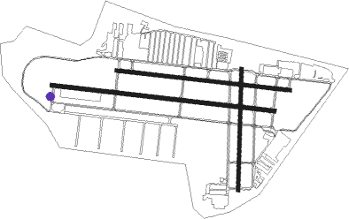
Runway info
Runway 10R / 28L  | ||
| length | 1521m (4990ft) | |
| bearing | 98° / 278° | |
| width | 30m (100ft) | |
| surface | asphalt | |
| Runway 10L / 28R | ||
| length | 1186m (3891ft) | |
| bearing | 98° / 278° | |
| width | 23m (75ft) | |
| surface | asphalt | |
| Runway 18 / 36 | ||
| length | 826m (2710ft) | |
| bearing | 188° / 8° | |
| width | 23m (75ft) | |
| surface | asphalt | |
Nearby beacons
| code | identifier | dist | bearing | frequency |
|---|---|---|---|---|
| FCM | FLYING CLOUD (MINNEAPOLIS VOR/DME | 0.6 | 98° | 117.70 |
| MSP | MINNEAPOLIS VOR/DME | 10.3 | 73° | 115.30 |
| FGT | FARMINGTON VORTAC | 16.6 | 125° | 115.70 |
| GEP | GOPHER (MINNEAPOLIS) VORTAC | 19.4 | 15° | 117.30 |
| RG | REGUE (RED WING) NDB | 37.2 | 106° | 274 |
| FOW | HALFWAY (MORRISTOWN) VOR/DME | 37.6 | 172° | 111.20 |
| MKT | MANKATO VOR/DME | 41.3 | 217° | 110.80 |
| ST | HUSSK (ST CLOUD) NDB | 44.6 | 322° | 342 |
| PNM | PRINCETON NDB | 44.7 | 349° | 368 |
| DWN | DARWIN VORTAC | 45 | 285° | 109 |
| OW | TONNA (OWATONNA) NDB | 47 | 158° | 379 |
| STC | SAINT CLOUD VOR/DME | 50.2 | 320° | 112.10 |
| ROS | RUSH CITY NDB | 56.3 | 30° | 282 |
Departure and arrival routes
| Transition altitude | 18000ft |
| Transition level | 18000ft |
| SID end points | distance | outbound heading | |
|---|---|---|---|
| RW10 (ALL) | |||
| COULT7 | 177mi | 109° | |
| ZMBRO7 | 102mi | 115° | |
| RST1 | 144mi | 155° | |
| ORSKY2 | 242mi | 212° | |
| SCHEP9 | 268mi | 246° | |
| DWN8 | 211mi | 277° | |
| RW18 | |||
| COULT7 | 177mi | 109° | |
| ZMBRO7 | 102mi | 115° | |
| RST1 | 144mi | 155° | |
| ORSKY2 | 242mi | 212° | |
| SCHEP9 | 268mi | 246° | |
| DWN8 | 211mi | 277° | |
| RW28 (ALL) | |||
| COULT7 | 177mi | 109° | |
| ZMBRO7 | 102mi | 115° | |
| RST1 | 144mi | 155° | |
| ORSKY2 | 242mi | 212° | |
| SCHEP9 | 268mi | 246° | |
| DWN8 | 211mi | 277° | |
| RW36 | |||
| COULT7 | 177mi | 109° | |
| ZMBRO7 | 102mi | 115° | |
| RST1 | 144mi | 155° | |
| ORSKY2 | 242mi | 212° | |
| SCHEP9 | 268mi | 246° | |
| DWN8 | 211mi | 277° | |
| STAR starting points | distance | inbound heading | |
|---|---|---|---|
| ALL | |||
| ENCEE2 | 85.5 | 83° | |
| GEP1 | 56.5 | 165° | |
| AGUDE5 | 48.8 | 254° | |
Instrument approach procedures
| runway | airway (heading) | route (dist, bearing) |
|---|---|---|
| RW10L | DRAIL (90°) | DRAIL SIGCO (10mi, 81°) 2800ft |
| RW10L | FGT (305°) | FGT KAPKE (24mi, 281°) 2900ft SIGCO (8mi, 15°) 2800ft |
| RW10L | GEP (195°) | GEP WAPAL (17mi, 237°) 2900ft SIGCO (6mi, 195°) 2800ft |
| RW10L | MAYER (100°) | MAYER SIGCO (12mi, 101°) 2800ft |
| RW10L | SIGCO (98°) | SIGCO 2800ft |
| RNAV | SIGCO 2800ft YODUC (6mi, 98°) 2100ft KFCM (4mi, 99°) 945ft (5552mi, 116°) 1400ft ONARE (5546mi, 296°) 2900ft ONARE (turn) 2900ft | |
| RW10R | GEP (195°) | GEP YICUK (19mi, 240°) 2700ft ZAMUD (5mi, 195°) 2700ft |
| RW10R | MAYER (100°) | MAYER ZAMUD (10mi, 103°) 2700ft |
| RW10R | PRIOR (358°) | PRIOR HOHNI (14mi, 280°) 2700ft ZAMUD (5mi, 15°) 2700ft |
| RW10R | ZAMUD (98°) | ZAMUD 2700ft |
| RNAV | ZAMUD 2700ft STUBR (7mi, 98°) 2600ft JIXUN (4mi, 98°) 1440ft KFCM (2mi, 98°) 938ft (5552mi, 116°) 1105ft JUDGU (5549mi, 296°) ONARE (9mi, 150°) 3000ft ONARE (turn) | |
| RW28L | FGT (305°) | FGT HERBO (10mi, 327°) 2500ft |
| RNAV | HERBO 2500ft ELOIT (4mi, 289°) 2100ft KFCM (4mi, 278°) 953ft (5552mi, 116°) 1148ft ZAMUD (5564mi, 296°) 2700ft ZAMUD (turn) | |
| RW28R | FGT (305°) | FGT VEYNY (10mi, 328°) 2600ft |
| RNAV | VEYNY 2600ft FATAR (4mi, 289°) 2100ft KFCM (4mi, 277°) 944ft (5552mi, 116°) 1150ft SIGCO (5562mi, 296°) 2800ft SIGCO (turn) | |
| RW36 | AHMIT (321°) | AHMIT OCEWA (15mi, 299°) 3000ft |
| RW36 | OCEWA (7°) | OCEWA 3000ft |
| RW36 | PRAGS (7°) | PRAGS OCEWA (8mi, 7°) 3000ft |
| RW36 | WULEP (35°) | WULEP OCEWA (7mi, 67°) 3000ft |
| RNAV | OCEWA 3000ft IJEYU (5mi, 8°) 2500ft JESVA (3mi, 8°) 1500ft KFCM (2mi, 2°) 935ft (5552mi, 116°) 2000ft OCEWA (5554mi, 296°) 3000ft OCEWA (turn) |
Holding patterns
| STAR name | hold at | type | turn | heading* | altitude | leg | speed limit |
|---|---|---|---|---|---|---|---|
| AGUDE5 | BEERI | VHF | right | 127 (307)° | 1.0min timed | ICAO rules | |
| ENCEE2 | WOOOD | VHF | left | 251 (71)° | < 17999ft | DME 10.0mi | ICAO rules |
| GEP1 | GOLLF | VHF | left | 333 (153)° | < 17999ft | 1.0min timed | ICAO rules |
| TWOLF3 | TWOLF | VHF | left | 178 (358)° | < 17999ft | 1.0min timed | ICAO rules |
| *) magnetic outbound (inbound) holding course | |||||||
Disclaimer
The information on this website is not for real aviation. Use this data with the X-Plane flight simulator only! Data taken with kind consent from X-Plane 12 source code and data files. Content is subject to change without notice.