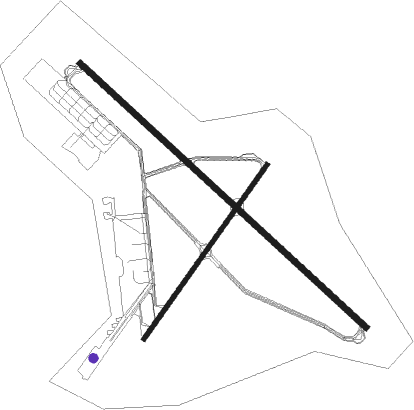
Topeka - Topeka Regl
Airport details
| Country | United States of America |
| State | Kansas |
| Region | K3 |
| Airspace | Kansas City Ctr |
| Municipality | Shawnee County |
| Elevation | 1078ft (329m) |
| Timezone | GMT -6 |
| Coordinates | 38.95094, -95.66361 |
| Magnetic var | |
| Type | land |
| Available since | X-Plane v10.40 |
| ICAO code | KFOE |
| IATA code | FOE |
| FAA code | FOE |
Communication
| Topeka Regl ATIS | 128.250 |
| Topeka Regl CTAF | 120.800 |
| Topeka Regl UNICOM | 122.950 |
| Topeka Regl Ground Control | 121.700 |
| Topeka Regl Tower | 120.800 |
| Topeka Regl KANSAS CITY CNTR Approach | 123.800 |
| Topeka Regl KANSAS CITY CNTR Departure | 123.800 |
Approach frequencies
| ILS-cat-I | RW31 | 110.1 | 18.00mi |
| 3° GS | RW31 | 110.1 | 18.00mi |
Nearby Points of Interest:
Horace G. Lyons House
-Chester B. Woodward House
-Topeka Council of Colored Women's Clubs Building
-Fire Station No. 2 (Topeka, Kansas)
-Hughes Conoco Service Station
-Ward-Meade House
-Hopkins House
-Pottawatomie Baptist Mission Building
-Spooner Hall
-Strong Hall
-United Presbyterian Center
-Lawrence's Downtown Historic District
-Granada Theater
-Haskell-Baker Wetlands
-S.T. Zimmerman House
-Osage County Courthouse
-Union Block
-Vinland Presbyterian Church
-Vinland Grange Hall
-Franklin County Courthouse
-Ottawa High School and Junior High School
-Dietrich Cabin
-Ottawa Library
-Arvonia School
-McFadden House
Nearby beacons
| code | identifier | dist | bearing | frequency |
|---|---|---|---|---|
| FOE | FORBES (TOPEKA) TACAN | 0.2 | 146° | 111.60 |
| TO | BILOY (TOPEKA) NDB | 10.2 | 352° | 521 |
| TOP | TOPEKA VORTAC | 12.3 | 32° | 117.80 |
| JZ | NEWBN (LAWRENCE) NDB | 23.9 | 94° | 338 |
| OWI | OTTAWA NDB | 31.1 | 135° | 251 |
| RN | HUGGY (KANSAS CITY) NDB | 43.3 | 67° | 416 |
| PK | HERBB (OLATHE) NDB | 44.9 | 102° | 420 |
| EMP | EMPORIA VORTAC | 45.4 | 216° | 112.80 |
| MCI | KANSAS CITY VORTAC | 47.6 | 70° | 113.25 |
| RBA | DME | 55.1 | 15° | 108.20 |
| ST | TARIO (ST JOSEPH) NDB | 55.9 | 46° | 260 |
| AZN | AMAZON (SAINT JOSEPH) NDB | 66 | 39° | 233 |
Instrument approach procedures
| runway | airway (heading) | route (dist, bearing) |
|---|---|---|
| RW03 | IDJOP (47°) | IDJOP 3000ft |
| RW03 | OKUXE (73°) | OKUXE 3600ft IDJOP (7mi, 123°) 3000ft |
| RW03 | ZULID (14°) | ZULID 3100ft IDJOP (7mi, 303°) 3000ft |
| RNAV | IDJOP 3000ft ANWOV (7mi, 47°) 2700ft HOVUR (4mi, 47°) 1560ft KFOE (2mi, 45°) 1125ft (5670mi, 112°) 1328ft VAJEG (5661mi, 292°) 3000ft VAJEG (turn) | |
| RW13 | DIHYE (155°) | DIHYE 3600ft JOFWO (5mi, 234°) 3600ft |
| RW13 | JOFWO (130°) | JOFWO 3600ft |
| RW13 | VAVTY (110°) | VAVTY 3600ft JOFWO (5mi, 54°) 3600ft |
| RNAV | JOFWO 3600ft IKBUF (6mi, 130°) 2700ft KFOE (6mi, 131°) 1115ft (5670mi, 112°) 1315ft ERJAG (5662mi, 292°) 3000ft ERJAG (turn) | |
| RW21 | JISIN (254°) | JISIN 3100ft VAJEG (7mi, 303°) 3000ft |
| RW21 | USOCO (193°) | USOCO 3100ft VAJEG (7mi, 123°) 3000ft |
| RW21 | VAJEG (227°) | VAJEG 3000ft |
| RNAV | VAJEG 3000ft KUDWE (7mi, 227°) 2700ft WOSAS (3mi, 227°) 1600ft KFOE (2mi, 229°) 1094ft (5670mi, 112°) 1293ft IDJOP (5678mi, 292°) 3000ft IDJOP (turn) | |
| RW31 | EPVAW (289°) | EPVAW 3000ft ERJAG (5mi, 234°) 3000ft |
| RW31 | ERJAG (310°) | ERJAG 3000ft |
| RW31 | HUDVO (334°) | HUDVO 3500ft ERJAG (5mi, 54°) 3000ft |
| RNAV | ERJAG 3000ft MOYLU (6mi, 310°) 2700ft KFOE (6mi, 309°) 1094ft JOFWO (12mi, 310°) 3600ft JOFWO (turn) |
Disclaimer
The information on this website is not for real aviation. Use this data with the X-Plane flight simulator only! Data taken with kind consent from X-Plane 12 source code and data files. Content is subject to change without notice.

