Westhampton Beach - Francis S Gabreski
Airport details
| Country | United States of America |
| State | New York |
| Region | K6 |
| Airspace | Boston Ctr |
| Municipality | Town of Southampton |
| Elevation | 65ft (20m) |
| Timezone | GMT -5 |
| Coordinates | 40.84367, -72.63177 |
| Magnetic var | |
| Type | land |
| Available since | X-Plane v10.40 |
| ICAO code | KFOK |
| IATA code | FOK |
| FAA code | FOK |
Communication
| Francis S Gabreski ASOS | 119.925 |
| Francis S Gabreski CTAF | 125.300 |
| Francis S Gabreski UNICOM | 122.950 |
| Francis S Gabreski Ground Control | 121.800 |
| Francis S Gabreski Tower | 125.300 |
| Francis S Gabreski NEW YORK Approach/Departure | 118.950 |
Approach frequencies
| ILS-cat-I | RW24 | 111.7 | 18.00mi |
| 3° GS | RW24 | 111.7 | 18.00mi |
Nearby Points of Interest:
Foster-Meeker House
-United States Post Office
-Crowther House
-Quogue Historic District
-James Benjamin Homestead
-Big Duck Ranch
-Vail-Leavitt Music Hall
-Suffolk County Historical Society Building
-Jedediah Hawkins House
-Jamesport Meeting House
-William Merritt Chase Homestead
-Hallock-Bilunas Farmstead
-Hallock Homestead
-Masury Estate Ballroom
-Shinnecock Hills Golf Club
-William Floyd House
-Beach Road Historic District
-Richard Cox House
-Andrew Gildersleeve Octagonal Building
-Jesse and Ira Tuthill House
-James L. Breese House
-Southampton Village Historic District
-Fort Corchaug Archaeological Site
-New Suffolk School
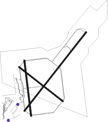
Runway info
Runway 6 / 24  | ||
| length | 2743m (8999ft) | |
| bearing | 50° / 230° | |
| width | 46m (150ft) | |
| surface | asphalt | |
| blast zone | 255m (837ft) / 255m (837ft) | |
| Runway 1 / 19 | ||
| length | 1526m (5007ft) | |
| bearing | 357° / 177° | |
| width | 46m (150ft) | |
| surface | asphalt | |
| Runway 15 / 33 | ||
| length | 1524m (5000ft) | |
| bearing | 125° / 305° | |
| width | 46m (150ft) | |
| surface | asphalt | |
| blast zone | 255m (837ft) / 255m (837ft) | |
Nearby beacons
| code | identifier | dist | bearing | frequency |
|---|---|---|---|---|
| FOK | SUFFOLK CO (WESTHAMPTON B TACAN | 0.3 | 181° | 111 |
| CCC | CALVERTON VOR/DME | 9.1 | 297° | 117.20 |
| HTO | HAMPTON (EAST HAMPTON) VORTAC | 15 | 77° | 113.60 |
| HVN | HAVEN DME | 27.6 | 329° | 109.80 |
| MAD | MADISON VOR/DME | 28.3 | 353° | 110.40 |
| BDR | BRIDGEPORT VOR/DME | 29.3 | 303° | 108.80 |
| DPK | DEER PARK VOR/DME | 30.6 | 266° | 117.70 |
| FR | FRIKK (FARMINGDALE) NDB | 38.8 | 265° | 407 |
| GON | GROTON VOR/DME | 39.2 | 50° | 110.85 |
| HFD | HARTFORD VOR/DME | 48 | 6° | 114.90 |
| CMK | CARMEL VOR/DME | 50.3 | 295° | 116.60 |
| ORW | NORWICH VOR/DME | 51.4 | 42° | 110 |
| PWL | PAWLING (POUGHKEEPSIE) VOR/DME | 70.7 | 314° | 114.30 |
Departure and arrival routes
| Transition altitude | 18000ft |
| Transition level | 18000ft |
| STAR starting points | distance | inbound heading | |
|---|---|---|---|
| ALL | |||
| NELIE3 | 65.9 | 177° | |
Instrument approach procedures
| runway | airway (heading) | route (dist, bearing) |
|---|---|---|
| RW06 | HTO (257°) | HTO ZATBO (26mi, 246°) 2600ft ZATBO (turn) 2600ft |
| RW06 | SARDI (28°) | SARDI ZATBO (11mi, 359°) 2600ft |
| RNAV | ZATBO 2600ft TAZZY (6mi, 50°) 1700ft CILVA (3mi, 50°) 880ft KFOK (3mi, 49°) 103ft (4621mi, 119°) 298ft MATTY (4616mi, 299°) 2000ft MATTY (turn) | |
| RW24 | CREAM (200°) | CREAM CIBNI (6mi, 184°) 2000ft MATTY (6mi, 146°) 2000ft |
| RW24 | HTO (257°) | HTO MATTY (8mi, 289°) 2000ft |
| RW24 | MATTY (231°) | MATTY 2000ft |
| RNAV | MATTY 2000ft HAGIK (5mi, 230°) 1500ft KFOK (5mi, 231°) 121ft (4621mi, 119°) 266ft ZATBO (4627mi, 299°) 2600ft ZATBO (turn) |
Disclaimer
The information on this website is not for real aviation. Use this data with the X-Plane flight simulator only! Data taken with kind consent from X-Plane 12 source code and data files. Content is subject to change without notice.