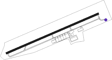
Glasgow - Glasgow Muni
Airport details
| Country | United States of America |
| State | Kentucky |
| Region | K5 |
| Airspace | Memphis Ctr |
| Municipality | Glasgow |
| Elevation | 714ft (218m) |
| Timezone | GMT -6 |
| Coordinates | 37.03178, -85.95375 |
| Magnetic var | |
| Type | land |
| Available since | X-Plane v10.40 |
| ICAO code | KGLW |
| IATA code | GLW |
| FAA code | GLW |
Communication
| Glasgow Muni AWOS-3 | 118.525 |
| Glasgow Muni CTAF/UNICOM | 122.800 |
| Glasgow Muni Memphis APCH | 132.900 |
| Glasgow Muni Memphis Departure | 132.900 |
Nearby Points of Interest:
Mammoth Cave Historic District
-Maintenance Area District
-Colossal Cavern Entrance
-Residential Area District
-Hercules and Coach No. 2
-Three Springs Pumphouse
-Mitchell-Estes Farmstead
-Bransford Spring Pumphouse
-Crystal Cave District
-Smiths Grove Presbyterian Church
-Smiths Grove Baptist Church
-Great Onyx Cave Entrance
-Munfordville Presbyterian Church and Green River Lodge No.88
-Sulphur Well Historic District
-Metcalfe County Jail
-Metcalfe County Kentucky Courthouse
-Reed-Dossey House
-Dr. Pellie G. Graves House
-J.L. Turner and Son Building
-Scottsville Downtown Commercial Historic District
-The Tabernacle
-Bell House
-William F. Perry Monument
-Mount Vernon AME Church
-First Colored Baptist Church
Nearby beacons
| code | identifier | dist | bearing | frequency |
|---|---|---|---|---|
| BWG | GREEN DME | 24.2 | 258° | 117.90 |
| BW | NOORA (BOWLING GREEN) NDB | 26.9 | 254° | 236 |
| EWO | NEW HOPE VOR/DME | 38.4 | 25° | 110.80 |
| LVT | LIVINGSTON VOR/DME | 46.4 | 120° | 108.40 |
| FTK | FORT KNOX VOR/DME | 52.5 | 359° | 109.60 |
| MYS | MYSTIC VOR | 53.6 | 341° | 108.20 |
| BNA | NASHVILLE VORTAC | 64.2 | 219° | 114.10 |
Instrument approach procedures
| runway | airway (heading) | route (dist, bearing) |
|---|---|---|
| RW08 | GIRME (75°) | GIRME 3000ft |
| RNAV | GIRME 3000ft HENTO (7mi, 75°) 2400ft JILUT (3mi, 75°) 1440ft KGLW (3mi, 75°) 744ft (5211mi, 113°) 971ft ZERAX (5200mi, 293°) 3000ft ZERAX (turn) | |
| RW26 | ZERAX (255°) | ZERAX 3000ft |
| RNAV | ZERAX 3000ft PAULL (7mi, 255°) 2400ft FIKSO (3mi, 255°) 1480ft KGLW (3mi, 255°) 755ft (5211mi, 113°) 1116ft GIRME (5223mi, 293°) 3000ft GIRME (turn) |
Disclaimer
The information on this website is not for real aviation. Use this data with the X-Plane flight simulator only! Data taken with kind consent from X-Plane 12 source code and data files. Content is subject to change without notice.
