Grayling - Grayling Aaf
Airport details
| Country | United States of America |
| State | Michigan |
| Region | K5 |
| Airspace | Minneapolis Ctr |
| Municipality | Grayling Charter Township |
| Elevation | 1158ft (353m) |
| Timezone | GMT -5 |
| Coordinates | 44.68033, -84.72886 |
| Magnetic var | |
| Type | land |
| Available since | X-Plane v10.40 |
| ICAO code | KGOV |
| IATA code | n/a |
| FAA code | GOV |
Communication
| GRAYLING AAF AWOS 3 | 119.075 |
| GRAYLING AAF CTAF | 126.200 |
| GRAYLING AAF Ground Control | 121.900 |
| GRAYLING AAF Tower | 126.200 |
| GRAYLING AAF MINNEAPOLIS Approach/Departure | 125.475 |
Nearby Points of Interest:
Edward E. Hartwick Memorial Building
-Douglas House (Lovells Township, Michigan)
-James A. and Lottie J.
-Frank A. and Rae E. Harris Kramer House
-Johannesburg Manufacturing Company Store
-Jordan River Pathway
-Oscoda County Courthouse
-Antrim County Courthouse
-Holtz Site
-M-88–Intermediate River Bridge
-Henry Richardi House
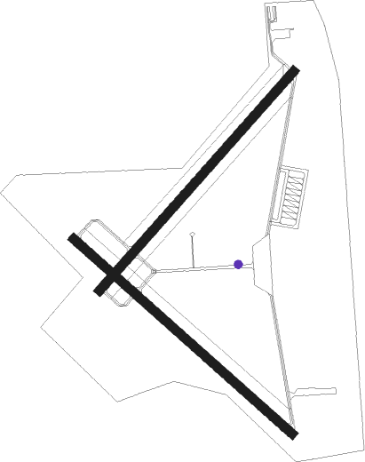
Runway info
Runway 5 / 23  | ||
| length | 1523m (4997ft) | |
| bearing | 56° / 236° | |
| width | 46m (150ft) | |
| surface | concrete | |
| blast zone | 255m (837ft) / 0m (0ft) | |
| Runway 14 / 32 | ||
| length | 1524m (5000ft) | |
| bearing | 127° / 307° | |
| width | 46m (150ft) | |
| surface | asphalt | |
| displ threshold | 0m (0ft) / 89m (292ft) | |
| blast zone | 255m (837ft) / 0m (0ft) | |
Nearby beacons
| code | identifier | dist | bearing | frequency |
|---|---|---|---|---|
| CGG | GRAYLING VOR | 0 | 13° | 109.80 |
| GYG | GRAYLING NDB | 5.9 | 305° | 359 |
| GLR | GAYLORD VOR/DME | 19.9 | 4° | 109.20 |
| GL | BANGU (GAYLORD) NDB | 20.3 | 347° | 375 |
| TV | GWENN (TRAVERSE CITY) NDB | 30 | 274° | 365 |
| TVC | TRAVERSE CITY VOR/DME | 35 | 269° | 114.60 |
| MA | WEXOR (CADILLAC) NDB | 44 | 242° | 336 |
| PLN | PELLSTON VORTAC | 57.1 | 4° | 111.80 |
Instrument approach procedures
| runway | airway (heading) | route (dist, bearing) |
|---|---|---|
| RW14 | BARAK (99°) | BARAK EGELE (11mi, 82°) 3500ft MAMER (5mi, 82°) 3000ft |
| RW14 | CARGA (81°) | CARGA LUMSE (8mi, 342°) 3500ft MAMER (5mi, 55°) 3000ft |
| RW14 | GLR (184°) | GLR EFFIT (10mi, 226°) 3000ft MAMER (5mi, 236°) 3000ft |
| RW14 | MAMER (126°) | MAMER 3000ft |
| RNAV | MAMER 3000ft HOCEY (6mi, 126°) 3000ft GUYEG (3mi, 126°) 1880ft KGOV (2mi, 123°) 1198ft (5180mi, 118°) 1560ft MAMER (5189mi, 298°) 3000ft MAMER (turn) |
Disclaimer
The information on this website is not for real aviation. Use this data with the X-Plane flight simulator only! Data taken with kind consent from X-Plane 12 source code and data files. Content is subject to change without notice.