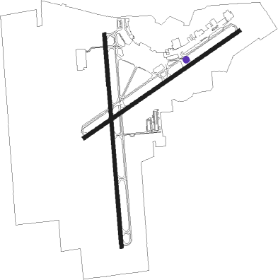
Green Bay - Green Bay A. Straubel Intl.
Airport details
| Country | United States of America |
| State | Wisconsin |
| Region | K5 |
| Airspace | Minneapolis Ctr |
| Municipality | Hobart |
| Elevation | 687ft (209m) |
| Timezone | GMT -6 |
| Coordinates | 44.48464, -88.12972 |
| Magnetic var | |
| Type | land |
| Available since | X-Plane v10.40 |
| ICAO code | KGRB |
| IATA code | GRB |
| FAA code | GRB |
Communication
| Green Bay A. Straubel Intl. ATIS | 124.100 |
| Green Bay A. Straubel Intl. CTAF | 118.700 |
| Green Bay A. Straubel Intl. Clearance DEL | 121.750 |
| Green Bay A. Straubel Intl. Green Bay Ground | 121.900 |
| Green Bay A. Straubel Intl. Green Bay Tower | 118.700 |
| Green Bay A. Straubel Intl. Green Bay Approach | 119.400 |
| Green Bay A. Straubel Intl. Green Bay Departure | 126.550 |
Approach frequencies
| ILS-cat-I | RW06 | 109.5 | 18.00mi |
| ILS-cat-I | RW36 | 109.9 | 18.00mi |
| 3° GS | RW06 | 109.5 | 18.00mi |
| 3° GS | RW36 | 109.9 | 18.00mi |
Nearby Points of Interest:
De Pere Public Library
-Old Nicolet High School
-North Broadway Street Historic District
-Otto and Hilda Gretzinger House
-De Pere Lock and Dam Historic District
-C. A. Lawton Company
-Edwin and Jennie Gutknecht House
-Green Bay Correctional Institution
-Tank Cottage
-Fort Howard Officers' Quarters
-Fort Howard Hospital
-Cotton House
-Massart Farmstead
-Baird Law Office
-Albert C. and Ellen H. Neufeld House
-Joel S. Fisk House
-Astor Historic District
-Milwaukee Road Passenger Depot
-Broadway-Walnut Historic District
-Broadway-Dousman Historic District
-Brown County Courthouse
-Kellogg Public Library and Neville Public Museum
-Angeline Champeau Rioux House
-Christ Episcopal Church Complex
-Mueller-Wright House
Nearby beacons
| code | identifier | dist | bearing | frequency |
|---|---|---|---|---|
| GRB | GREEN BAY VORTAC | 5 | 317° | 115.50 |
| SG | DEPRE (GREEN BAY) NDB | 5.1 | 182° | 332 |
| GR | FAMIS (GREEN BAY) NDB | 5.4 | 248° | 356 |
| AQ | KOOKY (APPLETON) NDB | 19.8 | 225° | 407 |
| MT | MAWOC (MANITOWOC) NDB | 25.1 | 124° | 362 |
| MTW | DME | 28.8 | 128° | 111 |
| II | FICHY (STURGEON BAY) NDB | 33.3 | 68° | 224 |
| OSH | OSHKOSH VORTAC | 34.8 | 221° | 116.75 |
| TN | TRIBE (MENOMINEE) NDB | 39.2 | 37° | 239 |
| OS | POBER (OSHKOSH) NDB | 41 | 215° | 395 |
| FAH | (SHEBOYGAN) DME | 44.6 | 159° | 110 |
| MNM | MENOMINEE VOR/DME | 46.5 | 35° | 109.60 |
Instrument approach procedures
| runway | airway (heading) | route (dist, bearing) |
|---|---|---|
| RW06 | BIPID (95°) | BIPID SHIRM (17mi, 109°) 2600ft KILBY (5mi, 141°) 2500ft |
| RW06 | GRB (137°) | GRB KILBY (16mi, 231°) 2500ft KILBY (turn) 2500ft |
| RW06 | OSH (41°) | OSH FLANA (19mi, 31°) 2600ft KILBY (5mi, 321°) 2500ft |
| RNAV | KILBY 2500ft TNDRA (10mi, 67°) 2400ft KGRB (6mi, 68°) 730ft (5325mi, 117°) 892ft HAMRO (5315mi, 297°) 2500ft HAMRO (turn) | |
| RW18 | AGOMA (259°) | AGOMA EDUBE (19mi, 283°) 2500ft ANEPE (5mi, 270°) 2500ft |
| RW18 | SHOOD (20°) | SHOOD ANEPE (26mi, 11°) 2500ft ANEPE (turn) 2500ft |
| RW18 | WOVET (109°) | WOVET DOBDE (13mi, 81°) 2500ft ANEPE (5mi, 90°) 2500ft |
| RNAV | ANEPE 2500ft FAVRE (6mi, 180°) 2400ft KGRB (6mi, 177°) 745ft (5325mi, 117°) 979ft SENNA (5325mi, 297°) 2500ft SENNA (turn) | |
| RW24 | BECKY (98°) | BECKY HAMRO (31mi, 87°) 2500ft HAMRO (turn) 2500ft |
| RW24 | NEROE (286°) | NEROE AMIDE (19mi, 302°) 2500ft HAMRO (5mi, 321°) 2500ft |
| RW24 | SPRYS (175°) | SPRYS CELNA (21mi, 144°) 2500ft HAMRO (5mi, 141°) 2500ft |
| RNAV | HAMRO 2500ft LMMBO (6mi, 248°) 2400ft KGRB (6mi, 247°) 731ft KILBY (15mi, 248°) 2500ft KILBY (turn) | |
| RW36 | GRB (137°) | GRB SENNA (17mi, 168°) 2500ft SENNA (turn) 2500ft |
| RW36 | OSH (41°) | OSH NISCO (21mi, 47°) 3000ft SENNA (5mi, 90°) 2500ft |
| RW36 | RABEE (299°) | RABEE MYZKA (12mi, 271°) 3100ft SENNA (5mi, 270°) 2500ft |
| RNAV | SENNA 2500ft FRZZN (7mi, 360°) 2200ft MAZTT (3mi, 360°) 1200ft KGRB (2mi, 6°) 734ft (5325mi, 117°) 884ft ANEPE (5325mi, 297°) 2500ft ANEPE (turn) |
Disclaimer
The information on this website is not for real aviation. Use this data with the X-Plane flight simulator only! Data taken with kind consent from X-Plane 12 source code and data files. Content is subject to change without notice.

