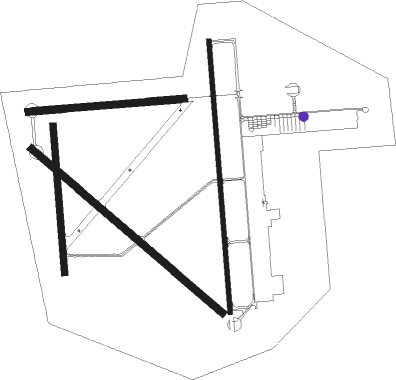
Hondo - Hondo Muni
Airport details
| Country | United States of America |
| State | Texas |
| Region | K4 |
| Airspace | Houston Oceanic Ctr |
| Municipality | Hondo |
| Elevation | 930ft (283m) |
| Timezone | GMT -6 |
| Coordinates | 29.35537, -99.16912 |
| Magnetic var | |
| Type | land |
| Available since | X-Plane v10.40 |
| ICAO code | KHDO |
| IATA code | HDO |
| FAA code | HDO |
Communication
| Hondo Muni ASOS | 119.675 |
| Hondo Muni CTAF/UNICOM | 122.725 |
Nearby Points of Interest:
Castroville Historic District
-Old Camp Verde
-Uvalde Downtown Historic District
-Kendall County Courthouse and Jail
-Prospect Hill Missionary Baptist Church
Runway info
Nearby beacons
| code | identifier | dist | bearing | frequency |
|---|---|---|---|---|
| HHH | DEVINE NDB | 17.7 | 133° | 359 |
| KSY | KELLY (SAN ANTONIO) TACAN | 30.8 | 86° | 112 |
| CSI | CENTER POINT (KERRVILLE) VORTAC | 34.1 | 355° | 117.50 |
| AN | ALAMO (SAN ANTONIO) NDB | 34.8 | 67° | 368 |
| SSF | STINSON (SAN ANTONIO) VOR | 38.4 | 98° | 108.40 |
| SAT | SAN ANTONIO VORTAC | 40.8 | 68° | 116.80 |
| RND | RANDOLPH VORTAC | 47.2 | 80° | 112.30 |
| DHK | RANDOLPH TACAN | 48.3 | 79° | 109.90 |
| CPZ | CHAPARROSA RANCH NDB | 51.9 | 240° | 385 |
| COT | COTULLA VORTAC | 53.7 | 177° | 115.80 |
| STV | STONEWALL VORTAC | 56.5 | 29° | 113.80 |
Instrument approach procedures
| runway | airway (heading) | route (dist, bearing) |
|---|---|---|
| RW17L | CSI (175°) | CSI JENDE (22mi, 173°) 3700ft |
| RW17L | JENDE (179°) | JENDE 3700ft |
| RW17L | SAT (248°) | SAT HIXUV (33mi, 263°) 4100ft JENDE (5mi, 263°) 3700ft |
| RNAV | JENDE 3700ft ORUNY (6mi, 180°) 2600ft CULRA (2mi, 180°) 1920ft KHDO (4mi, 177°) 974ft (5885mi, 106°) 1179ft MUNJO (5886mi, 286°) 4000ft MUNJO (turn) 4000ft | |
| RW35R | MUNJO (1°) | MUNJO 3500ft |
| RW35R | SAT (248°) | SAT KUXUJ (43mi, 232°) 4000ft MUNJO (5mi, 270°) 3500ft |
| RNAV | MUNJO 3500ft HOHME (6mi, 360°) 2600ft ZOMSU (3mi, 360°) 1500ft KHDO (2mi, 5°) 962ft (5885mi, 106°) 1170ft JENDE (5884mi, 287°) 3700ft JENDE (turn) |
Disclaimer
The information on this website is not for real aviation. Use this data with the X-Plane flight simulator only! Data taken with kind consent from X-Plane 12 source code and data files. Content is subject to change without notice.

