Portland - Portland Hillsboro
Airport details
| Country | United States of America |
| State | Oregon |
| Region | K1 |
| Airspace | Seattle Ctr |
| Municipality | Hillsboro |
| Elevation | 204ft (62m) |
| Timezone | GMT -8 |
| Coordinates | 45.54212, -122.95072 |
| Magnetic var | |
| Type | land |
| Available since | X-Plane v10.40 |
| ICAO code | KHIO |
| IATA code | HIO |
| FAA code | HIO |
Communication
| Portland Hillsboro ATIS | 127.650 |
| Portland Hillsboro UNICOM | 122.950 |
| Portland Hillsboro CTAF | 119.300 |
| Portland Hillsboro Ground Control | 121.700 |
| Portland Hillsboro HILLSBORO Tower | 119.300 |
| Portland Hillsboro PDX Approach/Departure | 126.000 |
Approach frequencies
| ILS-cat-I | RW13R | 110.7 | 18.00mi |
| 3° GS | RW13R | 110.7 | 18.00mi |
Nearby Points of Interest:
Shute–Meierjurgen Farmstead
-Malcolm McDonald House
-John and Elsie Parsons House
-Alvin T. Smith House
-Clark Historic District
-Painter's Woods Historic District
-Woods and Caples General Store
-Beaverton Downtown Historic District
-Dr. W. R. and Eunice Taylor House
-Moses and Ida Kline House
-J. S. and Melinda Waggener Farmstead
-Walker Naylor Historic District
-Bybee–Howell House
-St. Johns Post Office
-J. F. Watkins House
-Fogelbo House
-Ole and Polly Oleson Farmhouse
-E. J. O'Donnell House
-Joseph Jacobberger Country House
-Schanen–Zolling House
-Dr. Frank B. Kistner House
-McDougall–Campbell House
-Waldschmidt Hall
-Natt and Christena McDougall House
-Alexander D. McDougall House
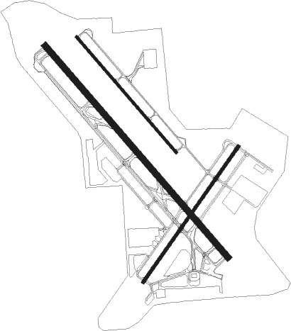
Runway info
Runway 13L / 31R  | ||
| length | 1091m (3579ft) | |
| bearing | 134° / 314° | |
| width | 18m (59ft) | |
| surface | asphalt | |
| Runway 13R / 31L | ||
| length | 2001m (6565ft) | |
| bearing | 134° / 314° | |
| width | 46m (151ft) | |
| surface | asphalt | |
| blast zone | 70m (230ft) / 70m (230ft) | |
| Runway 2 / 20 | ||
| length | 1185m (3888ft) | |
| bearing | 50° / 230° | |
| width | 22m (72ft) | |
| surface | asphalt | |
| blast zone | 45m (148ft) / 45m (148ft) | |
Nearby beacons
| code | identifier | dist | bearing | frequency |
|---|---|---|---|---|
| PND | BANKS (PORTLAND) NDB | 6.6 | 313° | 356 |
| UBG | NEWBERG VOR/DME | 11.4 | 188° | 117.40 |
| CBU | COLUMBIA (PORTLAND) TACAN | 14.5 | 82° | 109.20 |
| BTG | BATTLE GROUND VORTAC | 19.4 | 60° | 116.60 |
| SL | TURNO (SALEM) NDB | 41.7 | 180° | 266 |
| AST | ASTORIA VOR/DME | 53.8 | 304° | 114 |
| LWG | LEWISBURG (CORVALLIS) NDB | 57.3 | 199° | 225 |
Departure and arrival routes
| Transition altitude | 18000ft |
| Transition level | 18000ft |
| SID end points | distance | outbound heading | |
|---|---|---|---|
| RW02 | |||
| CANBY2 | 16mi | 141° | |
| FARM7 | 11mi | 188° | |
| SCAPO7 | 13mi | 340° | |
| RW13 (ALL) | |||
| CANBY2 | 16mi | 141° | |
| FARM7 | 11mi | 188° | |
| SCAPO7 | 13mi | 340° | |
| RW13R | |||
| CHISM4 | 123mi | 137° | |
| BERNI3 | 184mi | 179° | |
| RW20 | |||
| CANBY2 | 16mi | 141° | |
| FARM7 | 11mi | 188° | |
| SCAPO7 | 13mi | 340° | |
| RW31 (ALL) | |||
| CANBY2 | 16mi | 141° | |
| FARM7 | 11mi | 188° | |
| SCAPO7 | 13mi | 340° | |
| RW31L | |||
| CHISM4 | 123mi | 137° | |
| BERNI3 | 184mi | 179° | |
| STAR starting points | distance | inbound heading | |
|---|---|---|---|
| RW02 | |||
| HELNS6 | 19.4 | 240° | |
| OCITY3 | 14.6 | 283° | |
| RW13 (ALL) | |||
| HELNS6 | 19.4 | 240° | |
| OCITY3 | 14.6 | 283° | |
| RW20 | |||
| HELNS6 | 19.4 | 240° | |
| OCITY3 | 14.6 | 283° | |
| RW31 (ALL) | |||
| HELNS6 | 19.4 | 240° | |
| OCITY3 | 14.6 | 283° | |
Instrument approach procedures
| runway | airway (heading) | route (dist, bearing) |
|---|---|---|
| RW13R | BTG (240°) | BTG DUCKA (27mi, 275°) 4500ft DUCKA (turn) 3900ft |
| RW13R | DAFFI (163°) | DAFFI DUCKA (8mi, 261°) 4400ft DUCKA (turn) 3900ft |
| RW13R | UBG (8°) | UBG DUCKA (29mi, 331°) 4500ft DUCKA (turn) 3900ft |
| RNAV | DUCKA 3900ft COUVE (7mi, 133°) 3300ft DOLLA (3mi, 133°) 2900ft JIKIM (4mi, 133°) 1660ft KHIO (5mi, 133°) 248ft (6750mi, 110°) 1000ft UBG (6756mi, 290°) 3000ft UBG (turn) 3000ft | |
| RW31L | BONVL (272°) | BONVL CUKIS (22mi, 250°) 7000ft FLOWR (13mi, 250°) 5000ft NNIKE (10mi, 313°) 4000ft |
| RW31L | CUKIS (288°) | CUKIS FLOWR (13mi, 250°) 5000ft NNIKE (10mi, 313°) 4000ft |
| RW31L | ELKES (314°) | ELKES HOBGU (15mi, 314°) 7100ft FLOWR (10mi, 314°) 5000ft NNIKE (10mi, 313°) 4000ft |
| RW31L | MULES (284°) | MULES NNIKE (9mi, 247°) 4000ft |
| RW31L | VANTZ (334°) | VANTZ FLOWR (17mi, 6°) 5000ft NNIKE (10mi, 313°) 4000ft |
| RNAV | NNIKE 4000ft INTLL (6mi, 314°) 2000ft ZABAX (3mi, 314°) 880ft KHIO (3mi, 314°) 250ft (6750mi, 110°) 608ft DUCKA (6754mi, 290°) 3900ft DUCKA (turn) |
Holding patterns
| STAR name | hold at | type | turn | heading* | altitude | leg | speed limit |
|---|---|---|---|---|---|---|---|
| HELNS6 | HELNS | VHF | left | 360 (180)° | < 17999ft | 1.0min timed | ICAO rules |
| OCITY3 | MOXEE | VHF | right | 163 (343)° | 1.5min timed | ICAO rules | |
| OCITY3 | PORTL | VHF | right | 163 (343)° | DME 8.0mi | ICAO rules | |
| OCITY3 | VANTZ | VHF | right | 163 (343)° | 1.5min timed | ICAO rules | |
| *) magnetic outbound (inbound) holding course | |||||||
Disclaimer
The information on this website is not for real aviation. Use this data with the X-Plane flight simulator only! Data taken with kind consent from X-Plane 12 source code and data files. Content is subject to change without notice.