White Plains - Westchester Co
Airport details
| Country | United States of America |
| State | New York |
| Region | K6 |
| Airspace | Boston Ctr |
| Municipality | Town/Village of Harrison |
| Elevation | 437ft (133m) |
| Timezone | GMT -5 |
| Coordinates | 41.06695, -73.70757 |
| Magnetic var | |
| Type | land |
| Available since | X-Plane v10.40 |
| ICAO code | KHPN |
| IATA code | HPN |
| FAA code | HPN |
Communication
| Westchester Co ATIS | 133.800 |
| Westchester Co UNICOM | 122.950 |
| Westchester Co CTAF | 118.575 |
| Westchester Co Clearance DEL | 127.250 |
| Westchester Co Ground Control | 121.825 |
| Westchester Co Tower | 118.575 |
| Westchester Co NEW YORK Approach | 126.400 |
| Westchester Co NEW YORK Approach | 120.800 |
| Westchester Co NEW YORK Approach | 124.650 |
| Westchester Co NEW YORK Departure | 120.550 |
Approach frequencies
| ILS-cat-II | RW16 | 109.7 | 18.00mi |
| ILS-cat-I | RW34 | 109.7 | 18.00mi |
| 3° GS | RW16 | 109.7 | 18.00mi |
| 3° GS | RW34 | 109.7 | 18.00mi |
Nearby Points of Interest:
Stony Hill Cemetery
-Reid Hall, Manhattanville College
-New Mill and Depot Building, Hawthorne Woolen Mill
-Sylvanus Selleck Gristmill
-Round Hill Historic District
-Elijah Miller House
-Good Counsel Complex
-William E. Ward House
-Mapleton
-French Farm
-Presbyterian Rest for Convalescents
-Peoples National Bank and Trust Company Building
-Bar Building
-Bedford Road Historic District
-Jacob Purdy House
-Percy Grainger Home and Studio
-Rosemary Hall
-Nathaniel Witherell Historic District
-John Hartford House
-Usonia Historic District
-Thomas Lyon House
-Witthoefft House
-Byram School
-Fourth Ward Historic District
-St. Peter's Episcopal Church
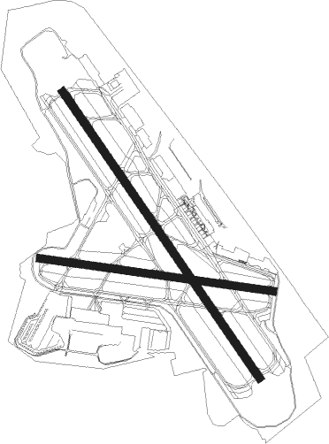
Runway info
Runway 11 / 29  | ||
| length | 1354m (4442ft) | |
| bearing | 99° / 279° | |
| width | 46m (151ft) | |
| surface | asphalt | |
| displ threshold | 0m (0ft) / 395m (1296ft) | |
| Runway 16 / 34 | ||
| length | 1997m (6552ft) | |
| bearing | 143° / 323° | |
| width | 46m (151ft) | |
| surface | asphalt | |
| blast zone | 61m (200ft) / 61m (200ft) | |
Nearby beacons
| code | identifier | dist | bearing | frequency |
|---|---|---|---|---|
| CMK | CARMEL VOR/DME | 14 | 31° | 116.60 |
| LGA | LA GUARDIA (NEW YORK) VOR/DME | 18.5 | 210° | 113.10 |
| FR | FRIKK (FARMINGDALE) NDB | 20.2 | 142° | 407 |
| TEB | TETERBORO VOR/DME | 20.7 | 238° | 108.40 |
| DPK | DEER PARK VOR/DME | 24.6 | 124° | 117.70 |
| TE | TORBY (TETERBORO) NDB | 24.9 | 238° | 214 |
| JFK | KENNEDY (NEW YORK) VOR/DME | 26.2 | 188° | 115.90 |
| BDR | BRIDGEPORT VOR/DME | 26.9 | 81° | 108.80 |
| CRI | CANARSIE VOR/DME | 28.5 | 202° | 112.30 |
| MM | MOREE (MORRISTOWN) NDB | 30.5 | 253° | 392 |
| SKU | STANWYCK (NEWBURGH) NDB | 31.5 | 324° | 261 |
| SW | NEELY (NEWBURGH) NDB | 34.4 | 309° | 335 |
| IGN | KINGSTON VOR/DME | 36.3 | 349° | 117.60 |
| SAX | SPARTA VORTAC | 37.6 | 270° | 115.70 |
| CAT | CHATHAM NDB | 38.1 | 246° | 254 |
| HVN | HAVEN DME | 38.9 | 77° | 109.80 |
| CCC | CALVERTON VOR/DME | 42 | 99° | 117.20 |
| PWL | PAWLING (POUGHKEEPSIE) VOR/DME | 42.4 | 9° | 114.30 |
| HUO | HUGUENOT VOR/DME | 44.9 | 291° | 116.10 |
| COL | COLTS NECK VOR/DME | 49.8 | 211° | 115.40 |
| RBV | ROBBINSVILLE VORTAC | 63.1 | 222° | 113.80 |
Departure and arrival routes
| Transition altitude | 18000ft |
| Transition level | 18000ft |
| SID end points | distance | outbound heading | |
|---|---|---|---|
| RW11 | |||
| HPN7 | 16mi | 147° | |
| RW16 | |||
| HPN7, PROP1 | 16mi | 147° | |
| RW29 | |||
| HPN7 | 16mi | 147° | |
| RW34 | |||
| HPN7 | 16mi | 147° | |
| STAR starting points | distance | inbound heading | |
|---|---|---|---|
| ALL | |||
| VALRE5 | 23.4 | 155° | |
| NOBBI5 | 31.6 | 180° | |
| RICED4 | 53.6 | 294° | |
| BOUNO4 | 43.6 | 340° | |
Instrument approach procedures
| runway | airway (heading) | route (dist, bearing) |
|---|---|---|
| RW16-Y | CMK (211°) | CMK FODAK (7mi, 267°) 3600ft BODRE (5mi, 246°) 2700ft |
| RW16-Y | SAX (90°) | SAX VOLLU (26mi, 77°) 3500ft BODRE (7mi, 76°) 2700ft |
| RNAV | BODRE 2700ft CZIMR (6mi, 142°) 2000ft IFADY (2mi, 143°) 1440ft KHPN (4mi, 143°) 494ft (4672mi, 119°) 689ft IKEWI (4669mi, 299°) KASYR (7mi, 58°) CMK (12mi, 348°) 2300ft CMK (turn) | |
| RW16-Z | ALIXX (250°) | ALIXX CUFDO (9mi, 277°) 3000ft EZHED (5mi, 277°) 2500ft CZIMR (5mi, 222°) 2000ft |
| RW16-Z | BASYE (162°) | BASYE BODRE (7mi, 196°) 2700ft CZIMR (6mi, 142°) 2000ft |
| RW16-Z | CMK (211°) | CMK FODAK (7mi, 267°) 2700ft IKAXE (6mi, 202°) 2000ft CZIMR (2mi, 171°) 2000ft |
| RW16-Z | VOLLU (114°) | VOLLU WALOB (4mi, 98°) 2400ft XCESS (4mi, 98°) 2000ft CZIMR (2mi, 118°) 2000ft |
| RNAV | CZIMR 2000ft KHPN (5mi, 143°) 494ft JIRUN (5mi, 142°) KIYBE (9mi, 70°) CMK (14mi, 334°) 3000ft CMK (turn) | |
| RW34-Y | BDR (261°) | BDR DABVE (12mi, 242°) 3000ft TUGME (9mi, 243°) 3000ft JETAX (5mi, 246°) 2000ft |
| RW34-Y | HAARP (247°) | HAARP MOISE (5mi, 121°) 3000ft TUGME (6mi, 179°) 3000ft JETAX (5mi, 246°) 2000ft |
| RW34-Y | RYMES (235°) | RYMES MOISE (8mi, 168°) 3000ft TUGME (6mi, 179°) 3000ft JETAX (5mi, 246°) 2000ft |
| RNAV | JETAX 2000ft ISLET (7mi, 323°) 1400ft KHPN (4mi, 322°) 435ft (4672mi, 119°) 723ft HEVAB (4675mi, 299°) CMK (12mi, 49°) 2300ft CMK (turn) | |
| RW34-Z | CMK (211°) | CMK NIDAE (5mi, 184°) 2500ft HAARP (5mi, 184°) 2000ft |
| RNAV | HAARP 2000ft IKILY (3mi, 141°) 2000ft KIBGE (6mi, 246°) 1400ft KHPN (3mi, 322°) 440ft HEVAB (4mi, 323°) FOXEK (8mi, 26°) CMK (6mi, 75°) 3000ft CMK (turn) |
Holding patterns
| STAR name | hold at | type | turn | heading* | altitude | leg | speed limit |
|---|---|---|---|---|---|---|---|
| BOUNO4 | ALIXX | VHF | left | 108 (288)° | < 17999ft | 1.0min timed | ICAO rules |
| BOUNO4 | DPK | NDB | right | 207 (27)° | < 17999ft | 1.0min timed | ICAO rules |
| NOBBI5 | CMK | NDB | left | 16 (196)° | < 17999ft | 1.0min timed | ICAO rules |
| NOBBI5 | CRALY | VHF | left | 44 (224)° | < 17999ft | 1.0min timed | 210 |
| NOBBI5 | NOBBI | VHF | left | 356 (176)° | < 17999ft | 1.0min timed | ICAO rules |
| NOBBI5 | RKA | NDB | left | 313 (133)° | 18000ft - 45000ft | DME 10.0mi | ICAO rules |
| RICED4 | ALIXX | VHF | left | 108 (288)° | < 17999ft | 1.0min timed | ICAO rules |
| VALRE5 | IGN | NDB | right | 13 (193)° | < 17999ft | 1.0min timed | ICAO rules |
| VALRE5 | VALRE | VHF | right | 23 (203)° | 6001ft - 14000ft | 1.0min timed | 210 |
| *) magnetic outbound (inbound) holding course | |||||||
Disclaimer
The information on this website is not for real aviation. Use this data with the X-Plane flight simulator only! Data taken with kind consent from X-Plane 12 source code and data files. Content is subject to change without notice.