Willoughby - Lake County Executive
Airport details
| Country | United States of America |
| State | Ohio |
| Region | K5 |
| Airspace | Cleveland Ctr |
| Municipality | Willoughby |
| Elevation | 625ft (190m) |
| Timezone | GMT -5 |
| Coordinates | 41.68403, -81.38975 |
| Magnetic var | |
| Type | land |
| Available since | X-Plane v10.40 |
| ICAO code | KLNN |
| IATA code | LNN |
| FAA code | LNN |
Communication
| Lake County Executive CTAF/UNICOM | 122.725 |
| Lake County Executive CLEVELAND Approach/Departure | 125.350 |
Nearby Points of Interest:
Mentor station
-Louis Penfield House
-Administration Building
-Sessions House
-St. James Episcopal Church
-South Leroy Meetinghouse
-Nela Park
-First Church of Christ in Euclid
-Forest Hill, Ohio
-Geauga County Courthouse
-Alta Public Library
-ASM Headquarters and Geodesic Dome
-Cozad-Bates House
-Flora Stone Mather College Historic District
-First Church of Christ, Scientist
-Ansel Road Apartment Buildings Historic District
-Allen Memorial Medical Library
-Adelbert Hall
-Cedar Glen Apartments
-Tower East
-Woodland-Larchmere Commercial Historic District
-Dr. James Bell House
-Lot Hathaway House
-Halle Brothers Shaker Square department store
-St. Luke's Hospital
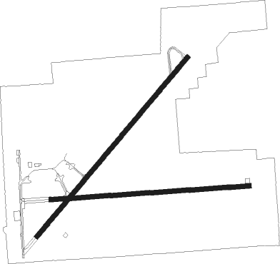
Runway info
Runway 5 / 23  | ||
| length | 1532m (5026ft) | |
| bearing | 53° / 233° | |
| width | 30m (100ft) | |
| surface | asphalt | |
| displ threshold | 131m (430ft) / 0m (0ft) | |
| Runway 10 / 28 | ||
| length | 1302m (4272ft) | |
| bearing | 90° / 270° | |
| width | 30m (100ft) | |
| surface | asphalt | |
| displ threshold | 0m (0ft) / 344m (1129ft) | |
Nearby beacons
| code | identifier | dist | bearing | frequency |
|---|---|---|---|---|
| LQL | LAKELAND (WILLOUGHBY) NDB | 0.4 | 99° | 263 |
| BF | TABEY (CLEVELAND) NDB | 10.7 | 238° | 248 |
| CXR | CHARDON VOR/DME | 14.2 | 126° | 112.70 |
| JFN | JEFFERSON VOR/DME | 29.1 | 83° | 115.20 |
| ACO | AKRON VOR/DME | 35.6 | 162° | 114.40 |
| AK | AKRON NDB | 36.8 | 180° | 362 |
| YNG | YOUNGSTOWN VORTAC | 38.5 | 116° | 109 |
| DJB | DRYER VOR/DME | 39.8 | 247° | 113.60 |
| YN | FETCH (YOUNGSTOWN/WARREN) NDB | 46 | 121° | 338 |
| BSV | BRIGGS VOR/DME | 56.6 | 183° | 112.40 |
| UCP | CASTLE (NEW CASTLE) NDB | 59.1 | 124° | 272 |
Departure and arrival routes
| Transition altitude | 18000ft |
| Transition level | 18000ft |
| SID end points | distance | outbound heading | |
|---|---|---|---|
| RW05 | |||
| MYCAR4 | 30mi | 68° | |
| AHMET4 | 102mi | 161° | |
| CAVVS4 | 107mi | 218° | |
| ZAAPA5 | 238mi | 249° | |
| GTLKE4 | 195mi | 266° | |
| RW10 | |||
| MYCAR4 | 30mi | 68° | |
| AHMET4 | 102mi | 161° | |
| CAVVS4 | 107mi | 218° | |
| ZAAPA5 | 238mi | 249° | |
| GTLKE4 | 195mi | 266° | |
| RW23 | |||
| MYCAR4 | 30mi | 68° | |
| AHMET4 | 102mi | 161° | |
| CAVVS4 | 107mi | 218° | |
| ZAAPA5 | 238mi | 249° | |
| GTLKE4 | 195mi | 266° | |
| RW28 | |||
| MYCAR4 | 30mi | 68° | |
| AHMET4 | 102mi | 161° | |
| CAVVS4 | 107mi | 218° | |
| ZAAPA5 | 238mi | 249° | |
| GTLKE4 | 195mi | 266° | |
| STAR starting points | distance | inbound heading | |
|---|---|---|---|
| ALL | |||
| ROLLN2 | 50.8 | 24° | |
| ROKNN3 | 67.6 | 56° | |
| BRWNZ4 | 38.2 | 102° | |
| TRYBE4 | 17.9 | 297° | |
Instrument approach procedures
| runway | airway (heading) | route (dist, bearing) |
|---|---|---|
| RW05 | CXR (306°) | CXR WERIS (14mi, 266°) 3100ft HEVRU (5mi, 306°) 2700ft |
| RW05 | FAILS (169°) | FAILS JUBDA (17mi, 225°) 2700ft HEVRU (5mi, 126°) 2700ft |
| RW05 | HEVRU (53°) | HEVRU 2700ft |
| RNAV | HEVRU 2700ft UBIYA (6mi, 53°) 2100ft KLNN (5mi, 54°) 664ft (5020mi, 117°) 1026ft HILEK (5013mi, 297°) 2300ft HILEK (turn) | |
| RW10 | CXR (306°) | CXR OYITI (21mi, 280°) 2900ft NEVTE (5mi, 0°) 2300ft |
| RW10 | FAILS (169°) | FAILS WADIV (10mi, 251°) 2300ft NEVTE (5mi, 180°) 2300ft |
| RW10 | NEVTE (90°) | NEVTE 2300ft |
| RNAV | NEVTE 2300ft HUSIS (6mi, 90°) 2000ft KLNN (4mi, 89°) 664ft (5020mi, 117°) 1026ft PADIY (5017mi, 297°) CXR (12mi, 135°) 2900ft CXR (turn) | |
| RW23 | CXR (306°) | CXR UROCE (14mi, 5°) 3000ft HILEK (5mi, 307°) 2300ft |
| RW23 | FAILS (169°) | FAILS HUDUG (6mi, 74°) 2300ft HILEK (5mi, 126°) 2300ft |
| RW23 | HILEK (232°) | HILEK 2300ft |
| RNAV | HILEK 2300ft ULUCA (6mi, 233°) 2000ft KLNN (5mi, 232°) 660ft (5020mi, 117°) 1026ft YACUT (5021mi, 297°) NEVTE (9mi, 279°) 2300ft NEVTE (turn) | |
| RW28 | CXR (306°) | CXR SUVNE (5mi, 23°) 2900ft WUTUR (5mi, 1°) 2900ft |
| RW28 | FAILS (169°) | FAILS OYEPA (14mi, 104°) 2900ft WUTUR (5mi, 181°) 2900ft |
| RW28 | WUTUR (271°) | WUTUR 2900ft |
| RNAV | WUTUR 2900ft ULIYE (6mi, 270°) 2400ft KLNN (6mi, 271°) 666ft (5020mi, 117°) 1026ft NEVTE (5030mi, 297°) 2300ft NEVTE (turn) |
Holding patterns
| STAR name | hold at | type | turn | heading* | altitude | leg | speed limit |
|---|---|---|---|---|---|---|---|
| BRWNZ4 | BRWNZ | VHF | left | 293 (113)° | DME 10.0mi | ICAO rules | |
| BRWNZ4 | DETMR | VHF | left | 282 (102)° | DME 10.0mi | ICAO rules | |
| BRWNZ4 | FRYYE | VHF | left | 284 (104)° | DME 10.0mi | ICAO rules | |
| ROKNN3 | ROKNN | VHF | right | 232 (52)° | DME 10.0mi | ICAO rules | |
| ROLLN2 | ROLLN | VHF | right | 198 (18)° | DME 10.0mi | ICAO rules | |
| TRYBE4 | DECRR | VHF | left | 120 (300)° | DME 10.0mi | ICAO rules | |
| TRYBE4 | HFNER | VHF | right | 78 (258)° | DME 10.0mi | ICAO rules | |
| TRYBE4 | TRYBE | VHF | left | 95 (275)° | DME 10.0mi | ICAO rules | |
| *) magnetic outbound (inbound) holding course | |||||||
Disclaimer
The information on this website is not for real aviation. Use this data with the X-Plane flight simulator only! Data taken with kind consent from X-Plane 12 source code and data files. Content is subject to change without notice.