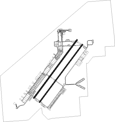
Airports for X-Plane offers a convenient way to explore airports and their related communication information for the X-Plane flight simulator. It only uses data from the X-Plane flight simulator itself, and is therefore more reliable than the data that comes from real aviation websites. You can search for airports by using the ICAO code, or browse for airports per country and state. The information displayed is categorized by airport details, runway information, airport communication, approach frequencies (ILS and Glidepath details), details of nearby beacons, SIDs, STARs and approach procedures.

taxiway bus military airdock airdrome airbus airport terminal drome airports immigration airport apron embassy southwest metro jetliner corporation runway lighting kennedy arrival frankfurt airport

Las Vegas - Nellis Afb

Airport details

CountryUnited States of America
StateNevada
RegionK2
AirspaceLos Angeles Ctr
MunicipalityClark County
Elevation1870ft (570m)
TimezoneGMT -8
Coordinates36.23620, -115.03426
Magnetic var
Typeland
Available sinceX-Plane v10.40
ICAO codeKLSV
IATA codeLSV
FAA codeLSV

Communication

Nellis AFB Clearance DEL120.900
Nellis AFB Ground Control121.800
Nellis AFB Tower132.550
Nellis AFB Approach118.125
Nellis AFB Approach124.950
Nellis AFB Departure135.100

Approach frequencies

ILS-cat-IRW21L109.118.00mi
3° GSRW21L109.118.00mi
Nearby Points of Interest:
Kyle Ranch
-
Old Las Vegas Mormon Fort State Historic Park
-
The Green Shack
-
Las Vegas Grammar School
-
Clark Avenue Railroad Underpass
-
Harrison's Guest House
-
Morelli House
-
Las Vegas High School Academic Building and Gymnasium
-
Las Vegas High School Neighborhood Historic District
-
Huntridge Theatre
-
Jay Dayton Smith House
-
Railroad Cottage Historic District
-
Las Vegas Springs
-
Eureka
-
Tule Springs Ranch
-
Boulder City Historic District
-
Boulder City Hospital
-
Sandstone Ranch
-
Willow Beach Gauging Station
-
Goodsprings Schoolhouse

Runway info

Runway 3L / 21R  
 length3085m (10121ft)
 bearing47° / 227°
 width61m (200ft)
 surfaceconcrete
 blast zone255m (837ft) / 255m (837ft)
Runway 3R / 21L  
 length3064m (10052ft)
 bearing47° / 227°
 width46m (150ft)
 surfaceconcrete
 blast zone255m (837ft) / 255m (837ft)

Nearby beacons

codeidentifierdistbearingfrequency
LSVNELLIS (LAS VEGAS) TACAN0.647°135.50
LASLAS VEGAS VORTAC11.1219°116.90
BLDBOULDER CITY VORTAC16.6145°116.70
GOGDME30.4233°112.05
INSINDIAN SPRINGS TACAN37.1299°114
MMMMORMON MESA VORTAC48.555°114.30

Disclaimer

The information on this website is not for real aviation. Use this data with the X-Plane flight simulator only! Data taken with kind consent from X-Plane 12 source code and data files. Content is subject to change without notice.